Kanswa

Last updated

Kanswa
Kansua
City
Shiv temple kansua, kota.jpg
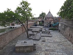
Shiva temple at Kanswa
CountryFlag of India.svg  India
State Rajasthan
Languages
  Official Hindi
Time zone UTC+5:30 (IST)
ISO 3166 code RJ-IN

Kanswa, also spelled Kansua, is a village in the Kota district of Rajasthan, India. It is of archaeological importance. [1] It is the site where James Tod found an inscription in 1820 AD that reveals the rule of the Jat king Maharaja Shalinder in Kota region in 5th century AD. [2] and Brahmin king Sankuka rule in 7th century whose son built the kansua Shiva Temple.

Related Research Articles

<span class="mw-page-title-main">Rajasthan</span> State in northwestern India

Rajasthan is a state in northern India. It covers 342,239 square kilometres (132,139 sq mi) or 10.4 per cent of India's total geographical area. It is the largest Indian state by area and the seventh largest by population. It is on India's northwestern side, where it comprises most of the wide and inhospitable Thar Desert and shares a border with the Pakistani provinces of Punjab to the northwest and Sindh to the west, along the Sutlej-Indus River valley. It is bordered by five other Indian states: Punjab to the north; Haryana and Uttar Pradesh to the northeast; Madhya Pradesh to the southeast; and Gujarat to the southwest. Its geographical location is 23.3 to 30.12 North latitude and 69.30 to 78.17 East longitude, with the Tropic of Cancer passing through its southernmost tip.

Rajput is a large multi-component cluster of castes, kin bodies, and local groups, sharing social status and ideology of genealogical descent originating from the Indian subcontinent. The term Rajput covers various patrilineal clans historically associated with warriorhood: several clans claim Rajput status, although not all claims are universally accepted. According to modern scholars, almost all Rajput clans originated from peasant or pastoral communities.

<span class="mw-page-title-main">James Tod</span> Officer of the British East India Company and an Oriental scholar (1782–1835)

Lieutenant-Colonel James Tod was an officer of the British East India Company and an Oriental scholar. He combined his official role and his amateur interests to create a series of works about the history and geography of India, and in particular the area then known as Rajputana that corresponds to the present day state of Rajasthan, and which Tod referred to as Rajast'han.

<span class="mw-page-title-main">Kota, Rajasthan</span> Metropolis in Rajasthan, India

Kota, previously known as Kotah, is a city located in the southeast of northern Indian state of Rajasthan. It is located about 240 kilometres (149 mi) south of the state capital, Jaipur, situated on the banks of Chambal River. With a population of over 1.2 million, it is the third most populous city of Rajasthan after Jaipur and Jodhpur, 46th most populous city of India and 53rd most populous urban agglomeration of India. It serves as the administrative headquarters for Kota district and Kota division. Kota is a major coaching hub of the country for competitive examination preparations and has a number of engineering and medical coaching institutes.

<span class="mw-page-title-main">Jhalawar</span> City in RAJASTHAN, India

Jhalawar is a city, municipal council and headquarter in Jhalawar district of the Indian state of Rajasthan. It is located in the southeastern part of the state. It was the capital of the former princely state of Jhalawar, and is the administrative Jhalawar district. Its district headquarters is Jhalawar. This district is the 22nd largest district of Rajasthan. This district is known by the nicknames of Cherrapunji of Rajasthan, Nagpur of Rajasthan, Brijnagar of Rajasthan etc. Cherrapunji of rajasthan because the highest rainfall in the whole of Rajasthan occurs in manoharthana town in this district. Gagron fort at the confluence of Kalisindh and Ahu river at some distance from Jhalawar It is situated which is one of the Jaldurg of Rajasthan and it is such a fort which is a standing fort without foundation. This fort was included in the UNESCO World Heritage List in 2013.

Gahlot is a clan of Rajputs Guhilot Rajputs ruled a number of kingdoms including Mewar, Banswara, Dungarpur, Pratapgarh, Shahpura, Bhavnagar, Palitana, Lathi and Vala. The variations of the name include Gehlot, Guhila, Gohil or Guhilot.

<span class="mw-page-title-main">Didwana</span> Municipality in Rajasthan, India

Didwana is the city and Municipality in Didwana-Kuchaman district of Rajasthan, India. The lion gateway of Marwar in Rajasthan and the archway of Merta, known as Abhanagri and Upakashi, is situated on the northern side of Didwana Salt lake in the north-eastern direction of Nagaur district. The people of Didwana speak the Rajasthani language of Marwadi, a language in the Indo-Aryan family similar to Hindi.

Rajput is a large multi-component cluster of castes, kin bodies, and local groups, sharing social status and ideology of genealogical descent originating from the Indian subcontinent. The term Rajput covers various patrilineal clans historically associated with warriorhood: several clans claim Rajput status, although not all claims are universally accepted. According to modern scholars, almost all Rajputs clans originated from peasant or pastoral communities.

<span class="mw-page-title-main">Kota district</span> District of Rajasthan in India

Kota District is a district of the state of Rajasthan in western India. The city of Kota is the administrative headquarters of the district.

<span class="mw-page-title-main">Bundi district</span> District of Rajasthan in India

Bundi is a district in the state of Rajasthan in western India. The city of Bundi is the district headquarters. It has an area of 5,550 km2 and a population of 1,110,906. It is divided into 5 tehsils which are: Bundi, Hindoli, Nainwa, Keshoraipatan and Indergarh.

<span class="mw-page-title-main">Bijolia</span> Town in Rajasthan, India

Bijoliya is a census town in Bhilwara district in the state of Rajasthan, India and is surrounded by nature and waterfalls and is famous for Tapodaya Teerth Kshetra and Mandakini Temple.

Vallipuram is a village in Vadamarachchi, near Point Pedro in Northern Province, Sri Lanka. The village is an ancient settlement with rich archeological remains. The village is home to the Vishnu temple Vallipuram Aalvar Kovil.

Qaimkhani is a Muslim community of India who were notable for ruling the Fatehpur-Jhunjhunu region in Rajasthan from the 1300s to the 1700s.

<span class="mw-page-title-main">History of Rajasthan</span> Brief history of the Indian state of Rajasthan

The history of human settlement in the west Indian state of Rajasthan dates back to about 5,000 years ago. Around 1400 BC, the Matsya tribe occupied the region. Parts of Rajsthan also belonged to the site of the Indus Valley Civilization. The early medieval period saw the rise of many Rajput kingdoms such as the Chauhans of Ajmer, Sisodias of Mewar, Gurjara-Pratihara and the Rathores of Marwar, as well as several Rajput clans such as the Gohil and the Shekhawats of Shekhawati. While Jat kingdoms include the Johiya of Jangaldesh, the Sinsinwars of Bharatpur State, as well as the Bamraulia clan and the Ranas of Dholpur.

Nadol is a census town in Desuri tehsil of Pali district, India. Ashapura Mataji temple and Shri Nadol Tirth attract pilgrims.

Rajasthani people or Rajasthanis are a group of Indo-Aryan peoples native to Rajasthan, a state in Northern India. Their language, Rajasthani, is a part of the western group of Indo-Aryan languages.

<span class="mw-page-title-main">Tripartite Struggle</span> Ninth-century struggle for control in Northern India

The Tripartite Struggle for control of northern India took place in the ninth century, among the Gurjara-Pratihara Empire, the Pala Empire and the Rashtrakuta Empire.

<span class="mw-page-title-main">Atru</span> Town in Rajasthan, India

Atru is a town in the Baran district in Rajasthan, India. It is located in the southeast of northern Indian state of Rajasthan. It is tehsil of Baran. It is located around 30 kilometres south of the Baran district. Atru tehsil is the biggest tehsil of the Baran district, and has 141 villages under its administration. There are many facilities like a railway station, a hospital, schools, markets, well equipped roads for traffic. The most famous festival is Dhanush lila on the occasion there is a fair is organized for 3 days.

Gaur is a Hindu Suryavanshi Rajput clan of India. They have ancient ancestry and find mention by James Tod as one of 36 royal races in his book Annals and Antiquities of Rajasthan The Gaur Rajputs once held a prominent position in Ajmer till the time of Prithviraj Chauhan. Gorwar region gets its name from this clan. In later years they lost the territories ruled by them. In 15th century, they fought at least 13 battles with Shekhawats were defeated and were reduced to feudetory or jagirdars in Shekhawati region. The Rajgarh territory was one of the last bastion of Gaur Rajputs during the times of Mughal Emperors, Humayun and Akber, which was lost to Kishan Singh in 17th century. Gaur Rajputs remained allies to Mughal till the time of Aurangzeb, whose political decisions, alienated Rathods, Sisodias, Hadas and Gaur Rajput from Mughals.

Zalim Singh (1739-1824), sometimes refer as Zalim Singh Jhala or Zalim Singh of Kotah, was an administrator, reformer and army commander of Kota state. He was the de facto ruler of Kota State from 1770 to until his death in 1824.

References

  1. The Department of Archaeology and Museums, Government of Rajasthan
  2. Tod, James. Annals and Antiquities of Rajasthan, Vol.1. pp. 621–22.

Coordinates: 27°14′N80°35′E / 27.233°N 80.583°E / 27.233; 80.583