Ezemvelo KZN Wildlife is a governmental organisation responsible for maintaining wildlife conservation areas and biodiversity in KwaZulu-Natal Province, South Africa. Their headquarters is in Queen Elizabeth Park situated on the northern slopes of Pietermaritzburg, the KwaZulu-Natal provincial capital. Prior to 1994, it was known as the Natal Parks Board.

The Great Fish River is a river running 644 kilometres (400 mi) through the South African province of the Eastern Cape. The coastal area between Port Elizabeth and the Fish River mouth is known as the Sunshine Coast. The Great Fish River was originally named Rio do Infante, after João Infante, the captain of one of the caravels of Bartolomeu Dias. Infante visited the river in the late 1480s.

Bathurst is about 12 kilometres (7.5 mi) inland from Port Alfred, on the R67 road, in the Eastern Cape province of South Africa, and is named after Henry Bathurst, 3rd Earl Bathurst, Secretary of State for the Colonies by Sir Rufane Donkin. Its chief claim to fame is that it was the early administrative centre established by the British Government for the 1820 British Settlers who were sent to the district as a buffer between the Cape Colony and the Xhosa pastoralists who were migrating southwards and westwards along the coast. Bathurst is now part of the Ndlambe Local Municipality in the Sarah Baartman District Municipality of the Eastern Cape.

The Maputaland-Pondoland bushland and thickets is one of the ecoregions of South Africa. It consists of the montane shrubland biome.

The Kwazulu-Cape coastal forest mosaic is a subtropical moist broadleaf forest ecoregion of South Africa. It covers an area of 17,800 square kilometers (6,900 sq mi) in South Africa's Eastern Cape and KwaZulu-Natal provinces.
Eastern Cape Parks are the national parks, marine protected areas, nature reserves and other nature conservation areas in the Eastern Cape province of South Africa. Eastern Cape Parks and Tourism Agency (ECPTA) is the governmental organisation responsible for maintaining wilderness areas and public nature reserves in the Eastern Cape, based in East London.

Great Fish River Nature Reserve is a nature reserve in Eastern Cape Province, South Africa that is managed by Eastern Cape Parks. The park has a total area of 45,000 ha, and has been operational since 1994. It comprises three historical nature reserves that have been combined into a single reserve:

Oviston Nature Reserve is a protected area in the Eastern Cape Province, South Africa. The nature reserve is managed by Eastern Cape Parks. It is located on the southern shores of the Gariep Dam.
The Rietvlei Wetland Reserve is a 663-hectare (1,640-acre) nature reserve situated in Table View, Western Cape, South Africa. It is managed by the City of Cape Town's Environmental Resource Management Department.
The Diep River Fynbos Corridor is a nature reserve located in the Blaauwberg region of Cape Town, South Africa. It forms part of the larger Table Bay Nature Reserve, which was established in June 2012.

The Broken Head Nature Reserve is a protected nature reserve located in the Northern Rivers region of New South Wales, Australia, adjacent to the promontory of Broken Head which lies approximately 9 km south of Cape Byron, the easternmost point of Australia. The 98-hectare (240-acre) reserve contains an intact segment of littoral rainforest. Much of the Australian littoral rainforests have been destroyed for agriculture, mining or housing. Species of tree include Tuckeroo, Broad-leaf Lilly Pilly, Native Elm, Pear Fruited Tamarind, Bennett's Ash, Bangalow Palm, Rusty Rose Walnut and Hoop Pine. The extremely rare Scented Acronychia may naturally occur here. Climbers such as Whip Vine and Lawyer Cane are very common. The weed lantana is a serious problem in disturbed areas. The area is noted for its Aboriginal culture, rainforest walks, whale watching, and fishing from pristine beaches.

The De Hoop Marine Protected Area lies between Arniston and the mouth of the Breede River on the south coast of South Africa adjacent to the De Hoop Nature Reserve. The MPA is 51 kilometres long, and extends 5 nautical miles to sea. The whole MPA is a restricted area and is part of the migratory route and calving area for Southern right whales. The area protects habitats for several economically important inshore reef fish species, and ensures the retention of marine biomass in this part of the coast. The limestone coastline is includes archaeological sites and middens that date back centuries. The MPA is close to the Breede River estuary and, provides protection for species like cob that breed in the estuary and then return to the ocean.
The Oorlogskloof Nature Reserve, covering 4,776 hectares, is located 10 km south of Nieuwoudtville in the Northern Cape, South Africa. The Oorlogskloof River runs along the eastern border of the reserve, while the western part is bordered by the Knersvlakte. Streams dissect the mountainous terrain, resulting in gorges, 36 natural pools and waterfalls found throughout the reserve. There are also examples of rock art in caves beside some of the plateaus of the reserve. There are a couple of day and overnight trails, totalling 146 km in length, with 10 log cabins.
The Trafalgar Marine Protected Area is an inshore conservation region in the territorial waters of South Africa in kwaZulu-Natal, between Port Edward and Margate.
The Double Mouth Nature Reserve, part of the greater East London Coast Nature Reserve, is a coastal reserve in the Wild Coast region of the Eastern Cape. Alongside it are the Quko River mouth and the 50-metre high Morgan Bay Cliffs.
The Kwelera Nature Reserve, part of the greater East London Coast Nature Reserve, is a coastal forest reserve in the Wild Coast region of the Eastern Cape. Access to the reserve is through the adjacent Kwelera National Botanical Garden. The reserve stretches from the Kwelera River on the eastern side, to the Gqunube River at the western end of the reserve.
The Blaauwkrantz Nature Reserve is a small reserve near Makhanda (Grahamstown) for the purpose of conserving the endangered Eastern Province rocky. Nearby the reserve is the Waters Meeting Nature Reserve and Buffalo Kloof Protected Environment. The Blaauwkrantz Pass (R67) runs along the length of the reserve, while the Bloukrans River bisects it horizontally.
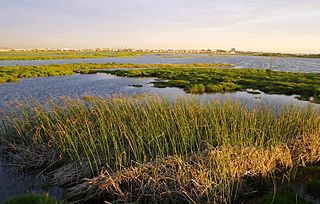
Great Fish River Mouth Wetland Nature Reserve is a wetland nature reserve that lies at the confluence of the Kap River, on the southern bank of the Great Fish River near Port Alfred. Neighbouring it is the Kap River Nature Reserve.
