Kapelludden

Last updated
Fishing sheds and the ruins of a chapel dedicated to Saint Birgitta Kapelludden - fishing sheds and chapel ruins.jpg
Fishing sheds and the ruins of a chapel dedicated to Saint Birgitta

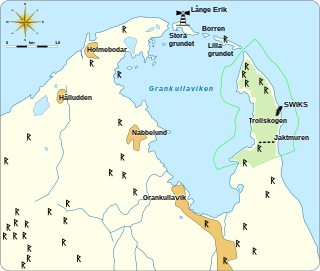
Kapelludden is a wetland on the east coast of the island of Öland, Sweden, some four kilometers from the village of Bredsättra in Bredsättra socken, Borgholm Municipality. The area is rich in birdlife, and has important cultural remains (including the ruins of Saint Birgitta's chapel) and a functioning Kapelludden lighthouse.

Öland Place

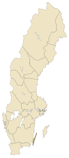
Öland is the second largest Swedish island and the smallest of the traditional provinces of Sweden. Öland has an area of 1,342 square kilometres and is located in the Baltic Sea just off the coast of Småland. The island has 26,000 inhabitants. It is separated from the mainland by the Kalmar Strait and connected to it by the 6-kilometre (3.7 mi) Öland Bridge, which opened on 30 September 1972.

Bredsättra socken is a former socken of Runsten Hundred on Öland, Sweden. Since 1974, it's part of the Borgholm Municipality on the island of Öland, Sweden. It covers 29.11 square kilometers and had 251 inhabitants in 2000.

Borgholm Municipality Municipality in Kalmar County, Sweden

Borgholm Municipality is a municipality in Kalmar County, south-eastern Sweden, constituting the northern half of the island of Öland in the Baltic Sea. The municipal seat is located in the city of Borgholm.

Kapelludden lighthouse Leuchtturm auf Kapelludden.JPG
Kapelludden lighthouse

Called Sik(a)varp or Sikehamn, the place was already a settlement for fishers in the Middle Ages and a trade center of uncertain importance, though local legendary stories claim that the settlement was so important that John III of Sweden revoked the town's trading privileges after complaints from Borgholm and Kalmar. [1]

John III of Sweden Swedish king

John III was King of Sweden from 1568 until his death. He was the son of King Gustav I of Sweden and his second wife Margaret Leijonhufvud. He was also, quite autonomously, the ruler of Finland, as Duke John from 1556 to 1563. In 1581 he assumed also the title Grand Prince of Finland. He attained the Swedish throne after a rebellion against his half-brother Eric XIV. He is mainly remembered for his attempts to close the gap between the newly established Lutheran Church of Sweden and the Catholic church.

Kalmar Place in Småland, Sweden

Kalmar is a city in the southeast of Sweden, situated by the Baltic Sea. It had 36,392 inhabitants in 2010 and is the seat of Kalmar Municipality. It is also the capital of Kalmar County, which comprises 12 municipalities with a total of 236,399 inhabitants (2015).

History

Whether the harbor of Sikvarp was really a commercially important place is not clear, and possibly exaggerated, especially since Johannes Haquini Rhezelius (d. 1666) describes it as a ruinous, derelict market town. No important ancient harbor structure appears to have existed, though there are remains of foundations and mounds.

Investigations in 1978 indicated mudflats, shallow pits lined with a layer of clay, and evidence was found of significant herring fisheries. The bishop of Linköping may have held the port in his private possessions, of strategic importance given the diocese's extensive land holdings to the west of Kapelludden. [1]

Diocese of Linköping diocese within the Church of Sweden

The Diocese of Linköping is a diocese within the Church of Sweden administering the Östergötland County, the north eastern part of Jönköping County and the northern part of Kalmar County. It comprises nine deaneries subdivided into 176 parishes with a total of 443,000 members. The dioecese's largest parish is Motala. The Diocese of Linköping has a rank directly below the Archdiocese of Uppsala of the Church of Sweden. The current bishop is Martin Modéus.

Related Research Articles

Halland Place in Götaland, Sweden

Halland  is one of the traditional provinces of Sweden, on the western coast of Sweden. It borders Västergötland, Småland, Scania and the sea of Kattegat. Until 1645 and the Second Treaty of Brömsebro, it was part of the Kingdom of Denmark.

Kalmar County County (län) of Sweden

Kalmar County is a county or län in southern Sweden. It borders the counties of Kronoberg, Jönköping, Blekinge and Östergötland. To the east in the Baltic Sea is the island Gotland.

Emmaboda Municipality Municipality in Kalmar County, Sweden

Emmaboda Municipality is a municipality in Kalmar County, in south-eastern Sweden. Its seat is located in the town Emmaboda.

Köpingsvik Place in Öland, Sweden

Köpingsvik is a locality situated in Borgholm Municipality, Kalmar County, Sweden with 599 inhabitants in 2010. It is located about 4 kilometres east of the city of Borgholm on the island Öland.

Öland County county in Sweden between 1819 and 1826

Öland County, or Ölands län, was a county of Sweden, between 1819 and 1826. It consisted of the island of Öland, designating the historical province of Öland as its own county. A Governor resided briefly at Borgholm, but the island is today part of the Kalmar County.

Kalmar Castle it has played a decisive role in Swedens history since the end of the 1100s and was considered one of Swedens most important strongholds, in 1397 in the castle was the formation of the Kalmar Union

Kalmar Castle is a castle in the city Kalmar in the province of Småland in Sweden.

Halltorp Öland

Halltorp is one of the earliest manor houses on the island of Öland, Sweden, dating from the 11th century AD. In early documents it is known as Hauldtorp, and it is cited as one of the early Viking settlements of Öland. In earlier times it has functioned as a royal farm associated with the Swedish Crown and was considered one of the finest hunting preserves on the island. There is a relict oak forest on the present grounds which contains numerous trees that are centuries old. Halltorp is in an area rich in history and biodiversity, and most of the island of Öland has been designated as a World Heritage Site. The site is adjacent to the perimeter highway, Route 136.

Grankullaviken bay

Grankullaviken is a shallow bay at the northern tip of Öland, Sweden, located in Böda socken, Borgholm Municipality. The bay is almost completely enclosed by two headlands and a few small shoal islands. Grankullavik is also the name of a village on the bay. The lighthouse Långe Erik on the Stora grundet island is officially named Ölands norra udde, even though the western headland extends a bit further north than the island upon which it stands. The eastern headland is the site of the windswept forest and nature reserve Trollskogen.

Saint Birgittas chapel church building in Borgholm Municipality, Sweden

Saint Birgitta's chapel is located on the east coast of the island of Öland, Sweden, some four kilometers from the village of Bredsättra in Bredsättra socken, Borgholm Municipality, in a marshy area called Kapelludden. The chapel dates from the 13th century; today nothing remains but the foundation and the eastern wall, the western wall having fallen down during a storm in 1914.

Borgholm Church Church in Borgholm, Sweden

Borgholm Church is a church in Borgholm on Swedish Baltic Sea island of Öland. Belonging to Borgholm Parish of the Church of Sweden, it was opened on Pentecost Sunday in 1879.

Astad is a village with less than 50 inhabitants (2005) on the island of Öland, Kalmar County, Sweden. It belongs to the municipality Borgholm.

Lofta is a small village on the island of Öland, Sweden. It belongs to the municipality of Borgholm, in Kalmar County.

Störlinge is a village on the island of Öland in the municipality of Borgholm, Kalmar County, Sweden. The village has 58 inhabitants (2005).

Sörby (Öland)

Sörby is a village in the municipality of Borgholm within the island province of Öland and the county of Kalmar in Sweden. It is in Gärdslösa socken. As of 2005 the village had 59 inhabitants.

Lindby is a village in the municipality Borgholm on the island Öland and the province Kalmar län in Sweden. The village has 60 inhabitants (2005).

Åkerby-Lopperstad is a village in the municipality Borgholm on the island Öland and the province Kalmar län in Sweden. The village had 73 inhabitants in 2010.

References

  1. 1 2 "Kapelludden" (in Swedish). Länsstyrelsen Kalmar län. Retrieved 7 April 2014.

Coordinates: 56°49′10″N16°50′42″E / 56.81944°N 16.84500°E / 56.81944; 16.84500

Geographic coordinate system Coordinate system

A geographic coordinate system is a coordinate system that enables every location on Earth to be specified by a set of numbers, letters or symbols. The coordinates are often chosen such that one of the numbers represents a vertical position and two or three of the numbers represent a horizontal position; alternatively, a geographic position may be expressed in a combined three-dimensional Cartesian vector. A common choice of coordinates is latitude, longitude and elevation. To specify a location on a plane requires a map projection.