Trollskogen

Last updated
Windswept pines with contorted shapes in Trollskogen Trollskogen Sweden.jpg
Windswept pines with contorted shapes in Trollskogen
Wreck of the three-masted schooner Swiks Trollskogen Shipwreck.jpg
Wreck of the three-masted schooner Swiks
Area map with Trollskogen's boundary in green. Map of Grankullaviken, Oland.svg
Area map with Trollskogen's boundary in green.

Trollskogen ("enchanted forest" or "troll's forest") is a windswept, grazed pine forest and nature reserve in the northeast corner of the Baltic island Öland, Sweden (Böda socken, Borgholm Municipality). The forest is on a promontory with an exposed shingle beach on the eastern side, the side of the Baltic Sea, and a sheltered bay on the western side, of Grankullaviken bay. The 100-hectare (250-acre) reserve, formerly a Domänreservat, (protected by the Swedish government forestry agency) is part of the Böda Kronopark. Its southeastern boundary is also the north border of the nature reserve Bödakusten östra.

Baltic Sea A sea in Northern Europe bounded by the Scandinavian Peninsula, the mainland of Europe, and the Danish islands

The Baltic Sea is a marginal sea of the Atlantic Ocean, enclosed by Denmark, Estonia, Finland, Latvia, Lithuania, Sweden, northeast Germany, Poland, Russia and the North and Central European Plain.

Öland Place

Öland is the second largest Swedish island and the smallest of the traditional provinces of Sweden. Öland has an area of 1,342 square kilometres and is located in the Baltic Sea just off the coast of Småland. The island has 26,000 inhabitants. It is separated from the mainland by the Kalmar Strait and connected to it by the 6-kilometre (3.7 mi) Öland Bridge, which opened on 30 September 1972.

Böda socken

Böda socken is a former socken of Åkerbo Hundred on Öland, Sweden. Since 1974, it's part of the Borgholm Municipality on the island of Öland, Sweden. It covers 107 square kilometers and had 773 inhabitants in 2000.

Contents

Description

Öland has a unique ecology containing many endemic and rare plants not found anywhere else. Trollskogen is characterized by its lichen-covered pine trees; those close to the exposed shore (a shingle beach) have been deformed by the wind. The interior of the forest contains pine trees, up to 200 years old, interspersed with old oaks, a remnant of the former grazing pastures in the Boda forests. Today, cattle still graze here, ensuring the biodiversity of the ecosystem, native grass and herb diversity. The western edge is formed by the grazed and forested areas of the Grankullaviken bay.

Lichen composite organism that arises from algae or cyanobacteria living among filaments of multiple fungi in a symbiotic relationship

A lichen is a composite organism that arises from algae or cyanobacteria living among filaments of multiple fungi species in a mutualistic relationship. The combined lichen has properties different from those of its component organisms. Lichens come in many colors, sizes, and forms. The properties are sometimes plant-like, but lichens are not plants. Lichens may have tiny, leafless branches (fruticose), flat leaf-like structures (foliose), flakes that lie on the surface like peeling paint (crustose), a powder-like appearance (leprose), or other growth forms.

Shingle beach

A shingle beach is a beach which is armoured with pebbles or small- to medium-sized cobbles. Typically, the stone composition may grade from characteristic sizes ranging from 2 to 200 millimetres diameter.

Ecosystem A community of living organisms together with the nonliving components of their environment

An ecosystem is a community of living organisms in conjunction with the nonliving components of their environment, interacting as a system. These biotic and abiotic components are linked together through nutrient cycles and energy flows. Energy enters the system through photosynthesis and is incorporated into plant tissue. By feeding on plants and on one-another, animals play an important role in the movement of matter and energy through the system. They also influence the quantity of plant and microbial biomass present. By breaking down dead organic matter, decomposers release carbon back to the atmosphere and facilitate nutrient cycling by converting nutrients stored in dead biomass back to a form that can be readily used by plants and other microbes.

The old oaks and pines are a rich habitat for lichens, [1] insects, fungi, and mosses. The rich flora of the reserve includes endangered and rare species such as Pachyphiale carneola, Calicium abietinum, and Sphinctrina. More common plants include burr chervil, Prince's pine, and Baltic wormwood.

Pachyphiale is a genus of fungi within the Gyalectaceae family.

<i>Calicium</i> genus of fungi

Calicium is a genus of leprose lichen lichens. It is in the family Caliciaceae. The genus has a widespread distribution and contains 30 species.

<i>Sphinctrina</i> genus of fungi

Sphinctrina is a genus of lichenized fungi within the Sphinctrinaceae family.

History

The oldest human traces in Trollskogen are some 15 cairns and stone circles. Grankullavik, formerly called Örboviken, was a naval base in the 15th century, dominating much of the central Baltic Sea. Traces of fortifications remain to the east and west, and a stone wall (possibly used to demarcate a hunting domain), some 230 feet (70 m) long and dating from the reign of King John III (15371592), remains to the south.

Cairn man-made pile of stones or burial monument

A cairn is a human-made pile of stones. The word cairn comes from the Scottish Gaelic: càrn[ˈkʰaːrˠn̪ˠ].

Stone circle monument of standing stones arranged in a circle

A stone circle is a circular alignment of standing stones. They are commonly found across Northern Europe and Great Britain and typically date from the Late Neolithic and Early Bronze Age eras, with most concentrations appearing from 3000 BC. The best known examples include those at the henge monument at Avebury, the Rollright Stones and elements within the ring of standing stones at Stonehenge. Ancient stone circles appear throughout Europe with many appearing in the Pyrenees, on the Causse de Blandas in southern France in the Cevennes, in the Alps, and Bulgaria.

Grankullavik Village in Öland, Sweden

Grankullavik is a village on the Grankullaviken bay in the north of Öland, Sweden, in the Böda socken, Borgholm Municipality.

The eastern shore is the site of the wreck of the Swiks , a schooner that was wrecked on the coast on 21 December 1926; its crew of seven escaped in a lifeboat.

Swiks

The Swiks was a three-masted schooner from Åland that sank in the Baltic Sea, off the island of Öland, Sweden, on 21 December 1926.

A schooner is a type of sailing vessel with fore-and-aft sails on two or more masts. The most common type has two masts, the foremast being shorter than the main. While the schooner was originally gaff-rigged, modern schooners typically carry a Bermuda rig.

Visitor information

The area has three hiking trails, with signage, one of which is accessible for strollers. A nature center at the parking area provides information on the area and its surroundings.

Baby transport wheeled baby transport

Various methods of transporting children have been used in different cultures and times. These methods include baby carriages, infant car seats, portable bassinets (carrycots), strollers (pushchairs), slings, backpacks, baskets and bicycle carriers.

Related Research Articles

Alvar Biological environment based on a limestone plain with thin or no soil and, as a result, sparse grassland vegetation

An alvar is a biological environment based on a limestone plain with thin or no soil and, as a result, sparse grassland vegetation. Often flooded in the spring, and affected by drought in midsummer, alvars support a distinctive group of prairie-like plants. Most alvars occur either in northern Europe or around the Great Lakes in North America. This stressed habitat supports a community of rare plants and animals, including species more commonly found on prairie grasslands. Lichen and mosses are common species. Trees and bushes are absent or severely stunted.

Biosphere reserves of Poland

UNESCO Biosphere Reserves are environment-protected scientific-research institutions of international status that are created with the intent for conservation in a natural state the most typical natural complexes of biosphere, conducting background ecological monitoring, studying of the surrounding natural environment, its changes under the activity of anthropogenic factors.

Lilla Karlsö nature reserve in Gotland, Sweden

Lilla Karlsö is a small Swedish island in the Baltic Sea, situated about 3 km (1.9 mi) off the west coast of Gotland and 4.5 km (2.8 mi) from Stora Karlsö; it is part of Eksta socken. It has an area of about 1.6 km2 (0.62 sq mi) and is 66 m (217 ft) high. Most of the island consists of a limestone plateau. Parts of the shoreline is bordered by steep cliffs. The island is mostly covered by alvar. There is also some very old broadleaf forest, which is unique for Gotland. There are several caves and up to 16 m (52 ft) high limestone pillars.

Mölle Place in Skåne, Sweden

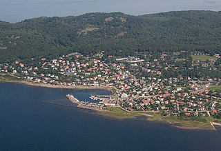
Mölle is a locality situated in Höganäs Municipality, Skåne County, Sweden with 715 inhabitants in 2010.

Creag Meagaidh mountain in the United Kingdom

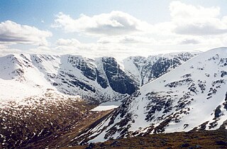
Creag Meagaidh is a mountain on the northern side of Glen Spean in the Highlands of Scotland. It is a complex mountain, taking the form of a flat summit plateau from which five ridges radiate, and is most famed for the cliffs surrounding the corrie of Coire Ardair on the north-eastern face. These crags are a renowned venue for winter and ice climbing, although being somewhat vegetated they are less suited to summer climbing.

Waquoit Bay

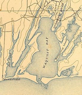
Waquoit Bay is a public national estuary, which is typically used as a research reserve. It is a part of Nantucket Sound and is located on the southern shore of Cape Cod in Massachusetts, USA. This bay forms the border of the towns of Falmouth, Massachusetts and Mashpee.

Kullaberg ås, berg

Kullaberg is a peninsula and nature reserve of land protruding into the Kattegat in Höganäs Municipality near the town of Mölle in southwest Sweden. The site in the province of Skåne is an area of considerable biodiversity supporting a number of rare species and has been designated as an Important Bird Area (IBA) in Sweden as well as a Special Protection Area (SPA). The terrain is dominated by steep cliffs rising from the sea and rocky outcrops on the ridge above, the highest elevation being Mount Håkull at 188 meters. Ridgetop vegetation includes a mixed hardwood broadleaf forest consisting of birch, beech, oak and pine trees with an understory of hawthorn, juniper, wild honeysuckle and blackthorn. Among the notable rare plants are spring vetchling, Lathyrus sphaericus.

State Reserves of Azerbaijan refers to the state reserves in Azerbaijan, which preserve the fauna, flora and their ecosystems.

Alby, Öland locality in Öland, Sweden

Alby is a village on the Baltic Sea in the Hulterstad district at the western fringe of the Stora Alvaret on the island of Öland, Sweden.

Dwarf forest

Dwarf forest, elfin forest, or pygmy forest is a rare ecosystem featuring miniature trees, inhabited by small species of fauna such as rodents and lizards. They are usually located at high elevations, under conditions of sufficient air humidity but poor soil. There are two main dwarf forest ecosystem types, involving different species and environmental characteristics: coastal temperate and montane tropical regions. Temperate coastal dwarf forest is common for parts of Southern California. Montane tropical forests are found across tropical highlands of Central America, northern South America and Southeast Asia. There are also other isolated examples of dwarf forests scattered across the world.

Flemingsbergsskogen Nature Reserve nature reserve in Stockholm, Sweden

Flemingsbergsskogen Nature Reserve is a nature reserve in Huddinge Municipality south of central Stockholm, Sweden.

Wasque ("way-squee") or Wasque Beach is a 200-acre (0.81 km2) nature reserve on Chappaquiddick Island, Martha's Vineyard, Massachusetts. The site was established as a reservation for the public in 1967 and is one of five conservation areas on "the Vineyard" managed by the Trustees of Reservations. Wasque contains a sandy strand the Boston Globe calls "a magnificent beach." Travel + Leisure named Wasque Beach the number one beach in New England and WHDH-TV reports "It's pristine, serene, and rain or shine, it's a beach-goers' delight." Off the shore of Wasque Beach is Katama Bay, "a vast and pristine salt water bay that includes many acres of productive shellfish beds."

Särö Västerskog nature reserve in Halland, Sweden

Särö Västerskog is a nature reserve located in Kungsbacka Municipality, Sweden, on a peninsula west of the locality of Särö. It was established in 1974 and is currently part of the Natura 2000 ecological network.

Grankullaviken bay

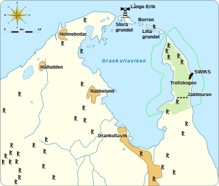
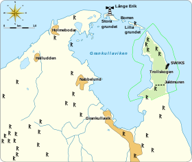
Grankullaviken is a shallow bay at the northern tip of Öland, Sweden, located in Böda socken, Borgholm Municipality. The bay is almost completely enclosed by two headlands and a few small shoal islands. Grankullavik is also the name of a village on the bay. The lighthouse Långe Erik on the Stora grundet island is officially named Ölands norra udde, even though the western headland extends a bit further north than the island upon which it stands. The eastern headland is the site of the windswept forest and nature reserve Trollskogen.

Nabbelund Village in Sweden

Nabbelund is a village in Böda socken, in the Borgholm Municipality of Öland, Sweden. Located on the western shore of the Grankullaviken bay, just south of the lighthouse Långe Erik and north of the village Grankullavik, it was formerly an important shipping port for timber.

Böda kronopark

Böda kronopark is a Kronopark and currently an Ekopark on Öland, Sweden, north of the village of Böda. It has 6000 hectares of mainly coniferous forest and takes up most of the northern part of Öland, except for the northwestern tip. Its eastern boundary is the Baltic Sea, with a ten-kilometer long sandy beach. The park was a royal hunting domain and then became part of the Domänverket. In 2006 the park became an Ekopark, meaning a park run by a forestry company, comparable to a nature reserve but with fewer regulations and allowing for the harvesting of lumber.

Byrums raukar nature reserve

Byrum's raukar are a geological formation of a group of stacks on the western shore in the north of Öland, Sweden near the village of Byrum. The group consists of about 120 limestone stacks, rich in fossils, of up to 4 m (13 ft) high on a 600 m (2,000 ft) stretch of beach. The area is about 3 hectares, is a Natural Monument III and a nature reserve since 1935.

Kandalaksha Nature Reserve

Kandalaksha Nature Reserve is a Russian 'zapovednik' on the south shore of Kandalaksha Bay in the Murmansk and Karelia regions on the opening to the White Sea. The reserve also includes two small sectors on the northern coast of the Kola peninsula on the Barents Sea; notably, the warm Atlantic current causes the northern sectors on the Barents Sea to be warmer than the more southerly White Sea sectors. Over 550 islands are covered in the boundaries of the reserve. It is one of the oldest nature reserves in Russia, created in 1932 to protect the marine habitats and waterfowl of the region, particularly the eider. The reserve is situated in the Kandalakshsky District, Kolsky District, and Lovozersky District of Murmansk Oblast. The nearest city, Kandalaksha, is at the northwest entrance to the Kandalaksha Gulf, about 5 km from the nearest point in the reserve. Since 1976, the reserve has been part of the RAMSAR wetland site of international importance "Kandalaksha Bay". It covers an area of 70,530 ha (272.3 sq mi).

References

  1. Knutsson, T.; T. Johansson; H. Lundkvist (1999). "Barkoch vedlevande lavar i Trollskogen, Böda, Oland" [Epiphytic and lignicolous lichens in Trollskogen, B6da, Oland, SE. Sweden]. Graphis Scripta . 10: 29–48.

Coordinates: 57°21′00″N17°07′24″E / 57.3501°N 17.1233°E / 57.3501; 17.1233