Oland is a small hallig which is connected by a narrow gauge railway to the mainland and to hallig Langeneß.

Cape Beale Lightstation is an active manned lighthouse on Vancouver Island in British Columbia., Canada.

The Langara Point Lighthouse is a manned lighthouse located atop a scenic bluff on the northwest corner of Langara Island. It is one of only two lighthouses in the Queen Charlotte Islands – the other being at Cape St. James, at the southern tip of the islands. Both were built in 1913.
Ottenby is a town on the island of Öland, Sweden, located in Ås parish, Mörbylånga Municipality in Kalmar County. Ottenby is located just north of the southern tip of Öland, over three miles south of the area's main town, Mörbylånga. Ottenby is also the name of the mansion and a royal demesne, now a nature reserve.

Vinga Lighthouse, is a Swedish lighthouse on Vinga island. The present-day lighthouse was built in 1890, although Vinga has been a significant island for mariners long before that. This lighthouse is the third built on the island. It is one of Sweden's most noted lighthouses and a special symbol for the city of Gothenburg.

The North Cape Light is an active lighthouse on Prince Edward Island, Canada. It was built in 1867, and is still active.

The Cape Tryon Light is a lighthouse on the western north coast of Prince Edward Island, Canada, located on Cousins Shore about 4 km (2.5 mi) west of the cape. The station was built in 1905 and it characterised as a white building with red trim; with the lantern painted red.

Oland lighthouse is Germany's smallest lighthouse, being only 7.4 metres (24 ft) tall. It is located on the small North Frisian island of Oland. It serves as a cross light for the Föhrer Ley and Dagebüll channels. It is Germany's only lighthouse with a thatched roof.

Dagebüll lighthouse is a retired lighthouse in Dagebüll, Nordfriesland, Germany. Until its replacement in 1988 by a direction light on the dock of the Dagebüll ferry port, it served as the lower light of the Dagebüll range of leading lights. The lighthouse is situated in the southern part of the municipality near the depot of the lorry rail to islands of Oland and Langeneß. After an additional storey was added to the tower due to a raise of the sea dike in 1980, the tower is now 12.5 m (41 ft) tall. Its focal height is at 10.3 m (34 ft) above the highest high tide. The lighthouse has a pitched roof, a black and green copper construction.

The Kidston Island Lighthouse is a lighthouse on Kidston Island, located in the Bras d'Or lakes, in Baddeck, Nova Scotia. The original lighthouse on Kidston Island was built in 1875. The present lighthouse was built in 1912 and the two stood side-by-side for some time. The lighthouse can only be accessed by boat; a ferry operates during the summer months.

Högby Lighthouse is a Swedish lightstation. The lighthouse is built of iron and painted white. The design by architect Johan Höjer is unique to Sweden. The tower was exhibited at the Stockholm Exposition in 1897 before being located in Högby on a narrow peninsula. The flame ran on kerosene at first, and was updated with a gas mantle light in 1908. It was electrified in 1945 with a 1000 watt bulb and fully automated in 1967. Today the light runs with a faint 60 watt bulb, and the old rotating Fresnel lens has been replaced. The lighthouse is owned by The Swedish Maritime Administration.
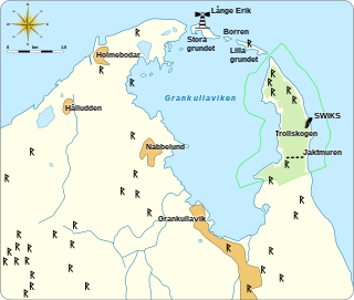
Grankullaviken is a shallow bay at the northern tip of Öland, Sweden, located in Böda socken, Borgholm Municipality. The bay is almost completely enclosed by two headlands and a few small shoal islands. Grankullavik is also the name of a village on the bay. The lighthouse Långe Erik on the Stora grundet island is officially named Ölands norra udde, even though the western headland extends a bit further north than the island upon which it stands. The eastern headland is the site of the windswept forest and nature reserve Trollskogen.

Böda socken is a former socken of Åkerbo Hundred on Öland, Sweden. Since 1974, it's part of the Borgholm Municipality on the island of Öland, Sweden. It covers 107 square kilometers and had 773 inhabitants in 2000.

Saint Olaf's chapel in Byxelkrok, on the island of Öland, Sweden, was built in 1976. The modernist design is by Anders Berglund. The chapel is in Böda socken in the Diocese of Växjö, and is one of three 20th century churches on the island.

Farol de Dona Maria Pia is a lighthouse at the southernmost point of the island of Santiago, Cape Verde. It stands on the headland Ponta Temerosa, at the entrance of Praia Harbour, 2 km south of the city centre of Praia. The lighthouse was built in 1881 and was named after Maria Pia of Savoy, queen of Portugal at the time. The octagonal tower is 21 m high and its focal plane is 25 m above mean sea level. It is painted white. The lighthouse is used for navigational purposes.