Svalbard is an archipelago in the Arctic Ocean roughly centered on 78° north latitude and 20° east longitude. The archipelago is the northernmost part of the Kingdom of Norway. The three main islands in the group consist of Spitsbergen, Nordaustlandet and Edgeøya. There are also a number of smaller islands, such as Barents Island (Barentsøya), Kvitøya, Prins Karls Forland, Kongsøya, Bear Island, Svenskøya, Wilhelm Island and other smaller islands or skerries.

Nils Christoffer Dunér was a Swedish astronomer. His parents were Nils Dunér and Petronella.
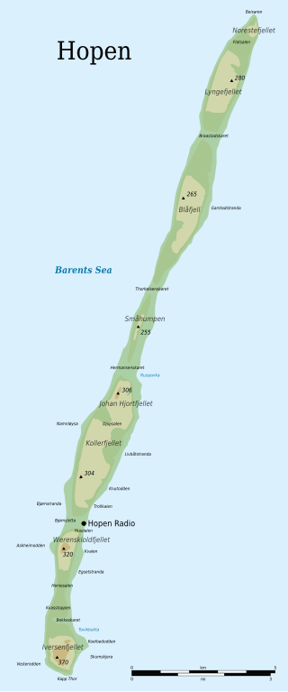
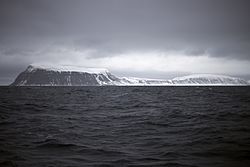
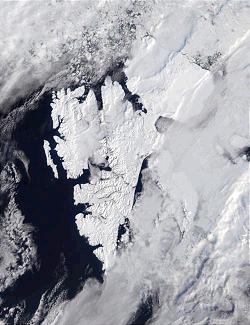
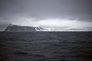
Hopen is an island in the southeastern part of the Svalbard archipelago (Norway). Hopen was discovered in 1596 by Jan Cornelisz Rijp during the third expedition by Willem Barentsz, trying to find the Northeast Passage. Later, in 1613, its name was given by Thomas Marmaduke of Hull, who named it after his former command, the Hopewell.
Tuscany is one of the 20 regions of Italy.

Kongsøya is an island in Svalbard, Norway. It is the largest of the islands in King Charles Land. Its area is 191 square kilometres (74 sq mi). The other main island in the chain is Svenskøya.

The following outline is provided as an overview of and topical guide to Svalbard:

Kapp Muyen is a cape just 107 m (350 ft) west of Beerenberg, the stratovolcano which forms the northeastern end of the Norwegian island of Jan Mayen. The point is named after the Dutch whaling master Willem Cornelisz. van Muyden, who was among the first to catch whales at Jan Mayen.
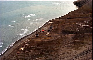
Hopen Radio is a coast radio station and the only settlement on the island of Hopen in Svalbard, Norway. It is located between Kollerfjellet and Werenskioldfjellet.
Hopen or Höpen may refer to:
Iversenfjellet is the highest mountain of Hopen in the Svalbard archipelago. It has a height of 371 m.a.s.l. and is located at the southern portion of Hopen. The mountain is named after fisheries consultant Thor Iversen.
Thor Iversen (1873–1953) was a Norwegian advisor to the Board of Fisheries. From 1923 he was in charge of the inspection of hunting and fishing in the Arctic Ocean. Among his books are Drivis og selfangst from 1927, and Ishavsøya Hopen from 1941.
Beisaren is the northernmost point of the island of Hopen in the Svalbard archipelago. It is named after hunter Berner Jørgensen, whose nickname was "Beisaren".
Kapp Platen is a headland at Nordaustlandet, Svalbard, the northernmost point of Prins Oscars Land. The headland is named after Swedish naval officer and politician Baltzar Julius Ernst von Platen. Kapp Platen includes the mountain Havsula.
Arnesenodden is a headland on Svenskøya in Kong Karls Land, Svalbard. It is the most northern point of Svenskøya, at the foot of the mountain Mohnhøgda. The headland is named after Arctic explorer Magnus Arnesen.
Kapp Hammerfest is a headland on Svenskøya in Kong Karls Land, Svalbard. It is the most southern point of Svenskøya, and the headland has a length of about 1.5 kilometers. The headland is named after the Norwegian city of Hammerfest. North of the headland, at the western side of the Svenskøya, is Kyrkjevika with Antarcticøya and other smaller islands.
Kapp Weissenfels is a headland on Svenskøya in Kong Karls Land, Svalbard. It is the most eastern point of Svenskøya, and the headland has a length of about 1.2 kilometers. The headland is named after the German city of Weißenfels. The outer point is about 25 meters high, and serves as a breeding place for guillemot, kittiwakes and ptarmigan. Nearby are sand beaches with undulating sand dunes.

Barentsburg Heliport, Heerodden is a private heliport located at Heerodden, serving the mining town of Barentsburg in Svalbard, Norway. The airport is owned and operated by Arktikugol, which also owns the company town. The airport features a 91-by-21-meter runway, two hangars and an administration building with a control tower. There are two Mil Mi-8 helicopters based at Heerodden, which are operated by Spark+. Flights are provided to Svalbard Airport, Longyear and Pyramiden Heliport.
Kapp Dunér is a headland at the island of Bjørnøya of the Svalbard archipelago, Norway. It is the westernmost point of Bjørnøya. The point is named after Swedish astronomer Nils Christoffer Dunér.
Werenskioldfjellet is a mountain at Hopen, Svalbard. The mountain is named after Norwegian geologist and Arctic explorer Werner Werenskiold.