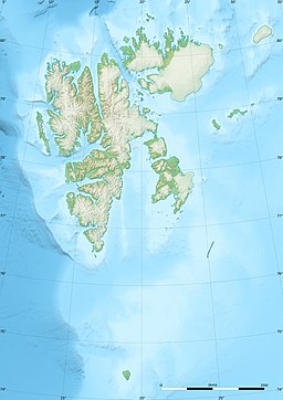
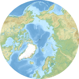
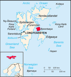
Svalbard is a Norwegian archipelago in the Arctic Ocean. Situated north of mainland Europe, it is about midway between continental Norway and the North Pole. The islands of the group range from 74° to 81° north latitude, and from 10° to 35° east longitude. The largest island is Spitsbergen, followed by Nordaustlandet and Edgeøya. While part of the Kingdom of Norway since 1925, Svalbard is not part of geographical Norway proper; administratively, the archipelago is not part of any Norwegian county, but forms an unincorporated area administered by a governor appointed by the Norwegian government, and a special jurisdiction subject to the Svalbard Treaty that is, unlike Norway proper, outside of the Schengen Area, the Nordic Passport Union and the European Economic Area. Since 2002, Svalbard's main settlement, Longyearbyen, has had an elected local government, somewhat similar to mainland municipalities. Other settlements include the Russian mining community of Barentsburg, the research station of Ny-Ålesund, and the mining outpost of Sveagruva. Ny-Ålesund is the northernmost settlement in the world with a permanent civilian population. Other settlements are farther north, but are populated only by rotating groups of researchers.

Svalbard is an archipelago in the Arctic Ocean roughly centered on 78° north latitude and 20° east longitude. The archipelago is the northernmost part of the Kingdom of Norway. The three main islands in the group consist of Spitsbergen, Nordaustlandet and Edgeøya. There are also a number of smaller islands, such as Barents Island (Barentsøya), Kvitøya, Prins Karls Forland, Kongsøya, Bear Island, Svenskøya, Wilhelm Island and other smaller islands or skerries.

The Svalbard Treaty recognises the sovereignty of Norway over the Arctic archipelago of Svalbard, at the time called Spitsbergen. The exercise of sovereignty is, however, subject to certain stipulations, and not all Norwegian law applies. The treaty regulates the demilitarisation of the archipelago. The signatories were given equal rights to engage in commercial activities on the islands. As of 2012, Norway and Russia are making use of this right.

The Norwegian Polar Institute is Norway's central governmental institution for scientific research, mapping and environmental monitoring in the Arctic and the Antarctic. The NPI is a directorate under Norway's Ministry of Climate and Environment. The institute advises Norwegian authorities on matters concerning polar environmental management and is the official environmental management body for Norwegian activities in Antarctica.

Hopen is an island in the southeastern part of the Svalbard archipelago (Norway). Hopen was discovered in 1596 by Jan Cornelisz Rijp during the third expedition by Willem Barentsz, trying to find the Northeast Passage. Later, in 1613, its name was given by Thomas Marmaduke of Hull, who named it after his former command, the Hopewell.
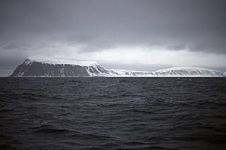
Barentsøya, sometimes anglicized as Barents Island, is an island in the Svalbard archipelago of Norway, lying between Edgeøya and Spitsbergen. Barents Island has no permanent human inhabitants. Named for the Dutch explorer Willem Barents, it is a part of Søraust-Svalbard Nature Reserve.

Danes Island is an island in Norway's Svalbard archipelago in the Arctic Ocean. It lies just off the northwest coast of Spitsbergen, the largest island in the archipelago, near to Magdalenefjorden. Just to the north lies Amsterdam Island. Like many of Svalbard's islands, Danes Island is uninhabited. The island has an area of 40.6 km2 (15.7 sq mi).

The following outline is provided as an overview of and topical guide to Svalbard:
Svalbard is an Arctic, wilderness series of islands comprising the northernmost part of the Norwegian territories. It is mostly uninhabited, with only about 3,000 people, yet covers an area of 61,020 square kilometres (23,560 sq mi).

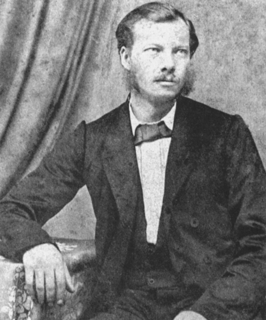
Werner Werenskiold was a Norwegian geologist and geographer. He was a son of Erik Werenskiold and visual artist Sophie Marie Stoltenberg Thomesen (1849–1926), and the brother of Dagfin Werenskiold.
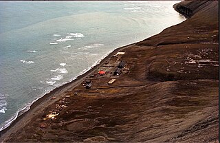
Hopen Radio is a coast radio station and the only settlement on the island of Hopen in Svalbard, Norway. It is located between Kollerfjellet and Werenskioldfjellet.
Thor Iversen (1873–1953) was a Norwegian advisor to the Board of Fisheries. From 1923 he was in charge of the inspection of hunting and fishing in the Arctic Ocean. Among his books are Drivis og selfangst from 1927, and Ishavsøya Hopen from 1941.
Kapp Thor is the southernmost point of Hopen in the Svalbard archipelago. It is named after fisheries advisor Thor Iversen.
Beisaren is the northernmost point of the island of Hopen in the Svalbard archipelago. It is named after hunter Berner Jørgensen, whose nickname was "Beisaren".
Dahlbreen is a glacier in Oscar II Land at Spitsbergen, Svalbard. It is named after whaler Thor Dahl. The glacier has a length of about fifteen kilometers, extending from Løvenskioldfonna to Forlandsundet. Among its tributary glaciers are Ujamnbreen, Bærumbreen and Fjelgbreen. Retreatment of the glacier has formed the bay of Dahlbrebukta.
Mohnbukta is a bay at the western shore of Storfjorden in Sabine Land at Spitsbergen, Svalbard. It is named after Norwegian meteorologist Henrik Mohn. The glacier of Hayesbreen is situated northwest of the bay. At the western side of the bay is the mountain of Kroghfjellet, and north of the bay is the mountain of Teistberget.
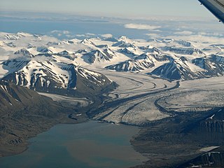
Paulabreen is a glacier in Nathorst Land and Heer Land at Spitsbergen, Svalbard. It has a length of about fifteen kilometers, extending from the mountain of Kjølberget to the bay of Rindersbukta. The glacier is named after Paula, the wife of shipmaster Richard Ritter von Barry. Paulabreen borders to the mountain area of Vriompeisen, and the mountain of Hollertoppen. A tributary glacier is Bakaninbreen.
Kollerfjellet is a mountain at Hopen, Svalbard. It has a height of 304 m.a.s.l., and its first known ascent was made in 1924 during topographic works.
Werenskioldfjellet is a mountain at Hopen, Svalbard. The mountain is named after Norwegian geologist and Arctic explorer Werner Werenskiold.
Krefftberget is a mountain group at Barentsøya, Svalbard. It is named after Australian zoologist Gerard Krefft, and is situated at the southern part of the island.