Related Research Articles

Svalbard ( SVAHL-bar, Urban East Norwegian: [ˈsvɑ̂ːɫbɑr]; previously known as Spitsbergen, or Spitzbergen, is a Norwegian archipelago in the Arctic Ocean. Situated north of mainland Europe, it is about midway between the northern coast of Norway and the North Pole. The islands of the group range from 74° to 81° north latitude, and from 10° to 35° east longitude. The largest island is Spitsbergen, followed by Nordaustlandet and Edgeøya, and the largest settlement is Longyearbyen.

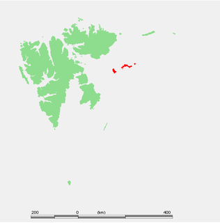
Hopen is an island in the southeastern part of the Svalbard archipelago (Norway). Hopen was discovered in 1596 by Jan Cornelisz Rijp during the third expedition by Willem Barentsz, trying to find the Northeast Passage. Later, in 1613, its name was given by Thomas Marmaduke of Hull, who named it after his former command, the Hopewell.

Danes Island is an island in Norway's Svalbard archipelago in the Arctic Ocean. It lies just off the northwest coast of Spitsbergen, the largest island in the archipelago, near to Magdalenefjorden. Just to the north lies Amsterdam Island. Like many of Svalbard's islands, Danes Island is uninhabited. The island has an area of 40.6 km2 (15.7 sq mi).
Kongsøya is an island in Svalbard, Norway. It is the largest of the islands in King Charles Land. Its area is 191 square kilometres (74 sq mi). The other main island in the chain is Svenskøya.

The following outline is provided as an overview of and topical guide to Svalbard:

Prof Sven Ludvig Lovén, was a Swedish marine zoologist and malacologist. The Sven Loven Centre for Marine Sciences within the University of Gothenburg was named in his honour.

Isfjord Radio is a coast radio station, weather station and hotel located at Kapp Linné on the island Spitsbergen in Svalbard, Norway. The station was established in 1933, and has played an important role in the telecommunications between the Svalbard archipelago and the outside world. The station was destroyed by both sides during World War II, and rebuilt in 1946. The station was important for ships traffic and air traffic. Satellite communications were established in 1979, but depreciated when a fiber optic cable between Svalbard and the mainland was finished in 2004. Isfjord Radio was automated and depopulated in 1999. Parts of the outdated installations have been preserved as a historical site.
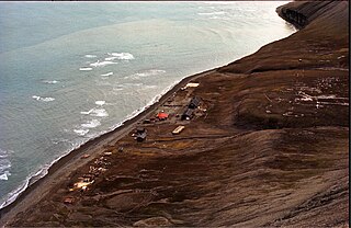
Hopen Radio is a coast radio station and the only settlement on the island of Hopen in Svalbard, Norway. It is located between Kollerfjellet and Werenskioldfjellet.
Platenhalvøya is a peninsula at Nordaustlandet, Svalbard, between Zorgdragerfjorden and Duvefjorden. The peninsula constitutes the northeastern part of Prins Oscars Land. The mountains Binneyfjellet and Goodenoughfjellet are among the highest peaks of Nordaustlandet.
Iversenfjellet is the highest mountain of Hopen in the Svalbard archipelago. It has a height of 371 m.a.s.l. and is located at the southern portion of Hopen. The mountain is named after fisheries consultant Thor Iversen.
Kapp Thor is the southernmost point of Hopen in the Svalbard archipelago. It is named after fisheries advisor Thor Iversen.
Beisaren is the northernmost point of the island of Hopen in the Svalbard archipelago. It is named after hunter Berner Jørgensen, whose nickname was "Beisaren".
Kapp Altmann is a headland at the southern side of Kongsøya in Kong Karls Land, Svalbard. It has a length of 1.9 kilometers and a width between 100 and 200 meters. Outside the spit are two small islands. The headland is named after Arctic explorer Johan Andreas Altmann. Kapp Altmann defines the western extension of the bay Breibukta.
Kapp Koburg is a headland at the western part of Kongsøya in Kong Karls Land, Svalbard. It is located at the western side of Hårfagrehaugen, and defines the southwestern extension of the bay Bünsowbukta.
Kapp Weissenfels is a headland on Svenskøya in Kong Karls Land, Svalbard. It is the most eastern point of Svenskøya, and the headland has a length of about 1.2 kilometers. The headland is named after the German city of Weißenfels. The outer point is about 25 meters high, and serves as a breeding place for guillemot, kittiwakes and ptarmigan. Nearby are sand beaches with undulating sand dunes.

Hornbækbukta is a bay at the southeastern side of the Norwegian island of Jan Mayen. It has a width of 2.2 kilometers, and extends from the headland of Fugleodden to the southwest, to Kapp Wien to the northeast. The bay is named after hydrographer Helge Hornbæk.
Kollerfjellet is a mountain at Hopen, Svalbard. It has a height of 304 m.a.s.l., and its first known ascent was made in 1924 during topographic works.
Werenskioldfjellet is a mountain at Hopen, Svalbard. The mountain is named after Norwegian geologist and Arctic explorer Werner Werenskiold.
Davisodden is a headland in Nathorst Land at Spitsbergen, Svalbard. It is named after American geomorphologist William Morris Davis. The headland is located at the northern side of Van Keulenfjorden, and is a river delta made by the river flowing through Davisdalen. Davisdalen extends from the mountain ridge of Mjellegga down to Davisodden. Its river is fed from several glaciers, including Martinbreen and Charpentierbreen.
Kapp Toscana is a headland at the southern side of Van Keulenfjorden in Wedel Jarlsberg Land at Spitsbergen, Svalbard. It is named after an Austrian family. West of the headland is the bay of Bourbonhamna, extending from Kapp Toscana to Kapp Madrid. East of the headland is the bay of Ingebrigtsenbukta, extending from Kapp Toscana to Ålesundneset.
References
- ↑ Godal, Anne Marit (ed.). "Ivar Thor Carl Iversen". Store norske leksikon (in Norwegian). Oslo: Norsk nettleksikon. Retrieved 2 July 2013.
- ↑ "Iversenfjellet (Svalbard)". Norwegian Polar Institute . Retrieved 2 July 2013.
- ↑ "Kapp Thor (Svalbard)". Norwegian Polar Institute . Retrieved 2 July 2013.
| | This Norwegian biographical article related to a government official is a stub. You can help Wikipedia by expanding it. |