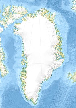
Greenland is located between the Arctic Ocean and the North Atlantic Ocean, northeast of Canada and northwest of Iceland. The territory comprises the island of Greenland—the largest island in the world—and more than a hundred other smaller islands. Greenland has a 1.2-kilometer-long (0.75 mi) border with Canada on Hans Island. A sparse population is confined to small settlements along certain sectors of the coast. Greenland possesses the world's second-largest ice sheet.
The Younger Dryas (YD) was a period in Earth's geologic history that occurred circa 12,900 to 11,700 years Before Present (BP). It is primarily known for the sudden or "abrupt" cooling in the Northern Hemisphere, when the North Atlantic Ocean cooled and annual air temperatures decreased by ~3 °C (5.4 °F) over North America, 2–6 °C (3.6–10.8 °F) in Europe and up to 10 °C (18 °F) in Greenland, in a few decades. Cooling in Greenland was particularly rapid, taking place over just 3 years or less. At the same time, the Southern Hemisphere experienced warming. This period ended as rapidly as it began, with dramatic warming over ~50 years, which transitioned the Earth from the glacial Pleistocene epoch into the current Holocene.
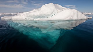
An iceberg is a piece of freshwater ice more than 15 meters long that has broken off a glacier or an ice shelf and is floating freely in open water. Smaller chunks of floating glacially derived ice are called "growlers" or "bergy bits". Much of an iceberg is below the water's surface, which led to the expression "tip of the iceberg" to illustrate a small part of a larger unseen issue. Icebergs are considered a serious maritime hazard.

In glaciology, an ice sheet, also known as a continental glacier, is a mass of glacial ice that covers surrounding terrain and is greater than 50,000 km2 (19,000 sq mi). The only current ice sheets are the Antarctic ice sheet and the Greenland ice sheet. Ice sheets are bigger than ice shelves or alpine glaciers. Masses of ice covering less than 50,000 km2 are termed an ice cap. An ice cap will typically feed a series of glaciers around its periphery.
The Greenland ice sheet is an ice sheet which forms the second largest body of ice in the world. It is an average of 1.67 km (1.0 mi) thick, and over 3 km (1.9 mi) thick at its maximum. It is almost 2,900 kilometres (1,800 mi) long in a north–south direction, with a maximum width of 1,100 kilometres (680 mi) at a latitude of 77°N, near its northern edge. The ice sheet covers 1,710,000 square kilometres (660,000 sq mi), around 80% of the surface of Greenland, or about 12% of the area of the Antarctic ice sheet. The term 'Greenland ice sheet' is often shortened to GIS or GrIS in scientific literature.

An ice stream is a region of fast-moving ice within an ice sheet. It is a type of glacier, a body of ice that moves under its own weight. They can move upwards of 1,000 metres (3,300 ft) a year, and can be up to 50 kilometres (31 mi) in width, and hundreds of kilometers in length. They tend to be about 2 km (1.2 mi) deep at the thickest, and constitute the majority of the ice that leaves the sheet. In Antarctica, the ice streams account for approximately 90% of the sheet's mass loss per year, and approximately 50% of the mass loss in Greenland.

A moulin is a roughly circular, vertical well-like shaft formed where a surface meltstream exploits a weakness in the ice. The term is derived from the French word for mill.
The Holocene glacial retreat is a geographical phenomenon that involved the global retreat of glaciers (deglaciation) that previously had advanced during the Last Glacial Maximum. Ice sheet retreat initiated ca. 19,000 years ago and accelerated after ca. 15,000 years ago. The Holocene, starting with abrupt warming 11,700 years ago, resulted in rapid melting of the remaining ice sheets of North America and Europe.

Jakobshavn Glacier, also known as Ilulissat Glacier, is a large outlet glacier in West Greenland. It is located near the Greenlandic town of Ilulissat and ends at the sea in the Ilulissat Icefjord.

The retreat of glaciers since 1850 is well documented and is one of the effects of climate change. The retreat of mountain glaciers provide evidence for the rise in global temperatures since the late 19th century. Examples include mountain glaciers in western North America, Asia, the Alps in central Europe and tropical and subtropical regions of South America and Africa. Since glacial mass is affected by long-term climatic changes, e.g., precipitation, mean temperature, and cloud cover, glacial mass changes are one of the most sensitive indicators of climate change. Retreat of glaciers is also a major reason for sea level rise. Excluding peripheral glaciers of ice sheets, the total cumulated global glacial losses over the 26-year period from 1993 to 2018 were likely 5500 gigatons, or 210 gigatons per yr.
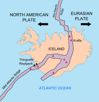
The geology of Iceland is unique and of particular interest to geologists. Iceland lies on the divergent boundary between the Eurasian plate and the North American plate. It also lies above a hotspot, the Iceland plume. The plume is believed to have caused the formation of Iceland itself, the island first appearing over the ocean surface about 16 to 18 million years ago. The result is an island characterized by repeated volcanism and geothermal phenomena such as geysers.

Glacier morphology, or the form a glacier takes, is influenced by temperature, precipitation, topography, and other factors. The goal of glacial morphology is to gain a better understanding of glaciated landscapes and the way they are shaped. Types of glaciers can range from massive ice sheets, such as the Greenland ice sheet, to small cirque glaciers found perched on mountain tops. Glaciers can be grouped into two main categories:

The Agassiz Ice Cap formerly Agassiz Glacier is an ice cap on the central eastern side of Ellesmere Island, Nunavut, Canada. The Agassiz ice cap is about 21,000 km2 (8,100 sq mi) in area. It is located between the North Ellesmere ice field to the north and the Prince of Wales Icefield to the south.

Greenland's climate is a tundra climate on and near the coasts and an ice cap climate in inland areas. It typically has short, cool summers and long, moderately cold winters.
Glacial earthquakes refer to a type of seismic event, with a magnitude of about 5, resulting from glacial calving events. The majority of glacial earthquake activity can be seen in the late summer and are found in Antarctica, Alaska, and Greenland. About 90% of these occur in Greenland. Glacial earthquakes occur most frequently in July, August, and September in Greenland. Seismographs are analyzed by scientists to identify and locate glacial earthquakes.

Rink Glacier is a glacier in Avannaata, Greenland.

Storstrommen, is one of the major glaciers in northeastern Greenland. The North-East Greenland Ice Stream (NEGIS) discharges into 3 main marine-terminating outlets: 79N Glacier, Zachariae Isstrøm and Storstrommen - as arranged North to South.
Twila Moon is a scientist at the National Snow and Ice Data Center known for her work on the Greenland ice sheet.
Ruth Mottram is a British climate scientist who is a researcher at the Danish Meteorological Institute. Her research considers the development of climate models and the dynamics of glaciers and ice sheets in the climate system.