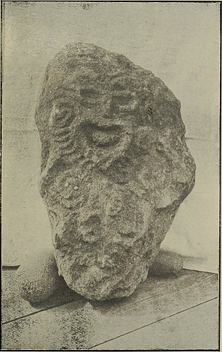
In Māori mythology, Rongo or Rongo-mā-Tāne is a major god (atua) of cultivated plants, especially kumara, a vital crop. Other crops cultivated by Māori in traditional times included taro, yams (uwhi), cordyline (tī), and gourds (hue). Because of their tropical origin, most of these crops were difficult to grow except in the far north of the North Island, hence the importance of Rongo in New Zealand.

Avaiki is one of the many names by which the peoples of Polynesia refer to their ancestral and spiritual homelands.

A marae, malaʻe, meʻae or malae is a communal or sacred place that serves religious and social purposes in Polynesian societies. In all these languages, the term also means cleared and free of weeds or trees. Marae generally consist of an area of cleared land roughly rectangular, bordered with stones or wooden posts perhaps with paepae (terraces) which were traditionally used for ceremonial purposes; and in some cases, a central stone ahu or a'u. In the Rapa Nui culture of Easter Island, the term ahu has become a synonym for the whole marae complex.

Mangaia is the most southerly of the Cook Islands and the second largest, after Rarotonga. It is a roughly circular island, with an area of 51.8 square kilometres (20.0 sq mi), 203 kilometres (126 mi) from Rarotonga. Originally heavily populated, Mangaia's population has dropped by 75% in the last 50 years, mainly due to the decline of the pineapple industry in the 1980s and a subsequent economic crisis in 1996.
Cook Islands Māori is an Eastern Polynesian language that is the official language of the Cook Islands. Cook Islands Māori is closely related to New Zealand Māori, but is a distinct language in its own right. Cook Islands Māori is simply called Māori when there is no need to disambiguate it from New Zealand Māori, but it is also known as Māori Kūki ʻĀirani or, controversially, Rarotongan. Many Cook Islanders also call it Te reo Ipukarea, literally "the language of the Ancestral Homeland".
Mangaia Airport is an airport on Mangaia in the Cook Islands. It lies 45 feet above mean sea level. In 2007, the airport received $5 million for development.

The conquered lorikeet is a species of parrot that became extinct 700–1300 years ago. It lived in islands of Polynesia. David Steadman and Marie Zarriello wrote its species description in 1987.

The Cook Islands Federation was created in 1891, after the Kingdom of Rarotonga was given the island of Aitutaki. It lasted until 1901, when it was given to New Zealand.
A Tapere or Sub-District is a low level of traditional land subdivision on five of the Southern Cook Islands, comparable to the ahupua'a of the main Hawaiian Islands or to the kousapw of Pohnpei. Among the populated raised islands, only Mitiaro is not subdivided into tapere. The remaining Southern Cook Islands, Manuae, Palmerston and Takutea are atolls and/or uninhabited, and therefore not subject to this type of traditional subdivision. The atolls of the Northern Cook Islands are subdivided into motu, instead.
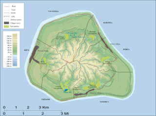
Kei'a is one of the six traditional districts of the island of Mangaia, which is part of the Cook Islands archipelago. It is located on the west side of the island, to the south of the District of Tava'enga and west of Veitatei. The district was traditionally divided into 6 tapere:
- Akaoro
- Tapuata
- Tongamarama
- Te-inati
- Rupetau-i-miri
- Rupetau-i-uta
Veitatei is one of the six traditional districts of the island of Mangaia in the Cook Islands. It is located in the south of the island, to the east of the District of Kei'a and west of the District of Tamarua. The district was traditionally divided into 6 tapere:
- Te-noki
- Te-tuaroa (Te-tukono)
- Te-tuapoto
- Te-tarapiki
- Kaikatu
- Angarino
Tamarua is one of the six traditional districts of the island of Mangaia, which is part of the Cook Islands archipelago. Tamarua is located in the southeast of Mangaia, to the south of the District of Ivirua and east of the District of Veitatei. The district was traditionally divided into 9 tapere:
- Maru-kore
- Poutoa-i-uta
- Poutoa-i-miri
- Akaea
- Te-vai-kao
- Angauru (Autaki)
- Vaitangi (Pukuotoi)
- Te-vai-taeta-i-uta
- Te-vai-taeta-i-tai
Ivirua is one of the six traditional districts of the island of Mangaia in the Cook Islands in the South Pacific Ocean. It is located in the east of the island, to the southeast of the District of Karanga and north of the District of Tamarua. The district was traditionally divided into 6 tapere:
- Te-pauru-o-Rongo
- Te-korokoro
- Te-uturei
- Te-ara-nui-o-Toi
- Te-i'i-maru
- Avarari
Tava'enga is one of the six traditional districts of the island of Mangaia in the Cook Islands, in the South Pacific Ocean. It is located in the north of the island, to the west of the District of Karanga and east of the District of Kei'a. The district was traditionally divided into 6 tapere:
- Te-pueu
- Te-mati-o-Pa'eru
- Au-ruia
- Maro
- Te-rupe
- Ta'iti
Oneroa is the largest village on Mangaia island, which is part of the Cook Islands archipelago. It is located in the west of the island, in the district of Kei'a, and contains over half of the island's population. Oneroa is a contiguous village area that consists of three villages, Tavaʻenga, Kaumata and Temakatea.
Akava'ine is a Cook Islands Māori word which has come, since the 2000s, to refer to transgender people of Māori descent from the Cook Islands.
Ivirua is a Cook Islands electoral division returning one member to the Cook Islands Parliament. Its current representative is Agnes Armstrong, who has held the seat since she won it in a by-election in 2019.

Arago hotspot is a hotspot in the Pacific Ocean, presently located below the Arago seamount close to the island of Rurutu, French Polynesia.

The Church of Jesus Christ of Latter-day Saints in the Cook Islands refers to the Church of Jesus Christ of Latter-day Saints and its members in Cook Islands. The first regularly held Sunday meetings began in 1943. In 2022, there were 1,862 members in 5 congregations.
