Māori, or te reo Māori, commonly shortened to te reo, is an Eastern Polynesian language spoken by the Māori people, the indigenous population of mainland New Zealand. A member of the Austronesian language family, it is closely related to Cook Islands Māori, Tuamotuan, and Tahitian. The Maori Language Act 1987 gave the language recognition as one of New Zealand's official languages.

Rarotonga is the largest and most populous of the Cook Islands. The island is volcanic, with an area of 67.39 km2 (26.02 sq mi), and is home to almost 75% of the country's population, with 10,898 of a total population of 15,040. The Cook Islands' Parliament buildings and international airport are on Rarotonga. Rarotonga is a very popular tourist destination with many resorts, hotels and motels. The chief town, Avarua, on the north coast, is the capital of the Cook Islands.

Penrhyn is an atoll in the northern group of the Cook Islands in the south Pacific Ocean. The northernmost island in the group, it is located at 1,365 km (848 mi) north-north-east of the capital island of Rarotonga, 9 degrees south of the equator. Its nearest neighbours are Rakahanga and Manihiki, approximately 350 kilometres (220 mi) to the southwest. Once one of the most heavily populated atolls, it was almost completely depopulated by Peruvian slavers in 1864.

Mangaia is the most southerly of the Cook Islands and the second largest, after Rarotonga. It is a roughly circular island, with an area of 51.8 square kilometres (20.0 sq mi), 203 kilometres (126 mi) from Rarotonga. Originally heavily populated, Mangaia's population has dropped by 75% in the last 50 years, mainly due to the decline of the pineapple industry in the 1980s and a subsequent economic crisis in 1996.

Atafu, formerly known as the Duke of York Group, is a group of 52 coral islets within Tokelau in the south Pacific Ocean, 500 kilometres north of Samoa. With a land area of 2.5 square kilometres, it is the smallest of the three islands that constitute Tokelau. It is an atoll and surrounds a central lagoon, which covers some 15 km2 (5.8 sq mi). The atoll lies 800 kilometres south of the equator at 8° 35' South, 172° 30' West.
Cook Islands Māori is an Eastern Polynesian language that is the official language of the Cook Islands. Cook Islands Māori is closely related to New Zealand Māori, but is a distinct language in its own right. Cook Islands Māori is simply called Māori when there is no need to disambiguate it from New Zealand Māori, but it is also known as Māori Kūki ʻĀirani or, controversially, Rarotongan. Many Cook Islanders also call it Te reo Ipukarea, literally "the language of the Ancestral Homeland".

Mitiʻāro, the fourth island in the Cook Islands group, is of volcanic origin. Standing in water 14,750 feet (4,500 m) deep it is four miles (6.4 km) across at its widest point.
Waitaha, an early Māori iwi, inhabited the South Island of New Zealand. They were largely absorbed via marriage and conquest - first by the Ngāti Māmoe and then by Ngāi Tahu - from the 16th century onward. Today those of Waitaha descent are represented by the Ngāi Tahu iwi. Like Ngāi Tahu today, Waitaha was itself a collection of various ancient iwi. Kāti Rākai was said to be one of Waitaha's hapū.
Rakahanga-Manihiki is a Tahitic language belonging to the Polynesian language family, spoken by about 2500 people on Rakahanga and Manihiki Islands and another 2500 in other countries, mostly New Zealand and Australia. Wurm and Hattori consider Rakahanga-Manihiki as a distinct language with "limited intelligibility with Rarotongan". According to the New Zealand Maori anthropologist Te Rangi Hīroa who spent a few days on Rakahanga in the years 1920, "the language is a pleasing dialect and has closer affinities with [New Zealand] Maori than with the dialects of Tongareva, Tahiti, and the Cook Islands"

Titoki is a locality in the Mangakahia Valley of the Northland Region of New Zealand's North Island. Whangarei is 26 km to the east. The Wairua River passes to the east of Titoki, and the Mangakahia River to the west. A hydroelectric plant has been operating at Wairua Falls since 1916. It was upgraded to produce 5.4 Gwh per year in 2007.
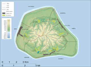
Karanga is the smallest of the six traditional districts of the island of Mangaia, in the Cook Islands archipelago. Karanga is located in the northeast of the island, to the east of the District of Tava'enga and northwest of the District of Ivirua. The district was traditionally divided into 5 tapere:
- Kaau-i-uta
- Kaau-i-miri
- Teia-pini
- Teia-poto
- Teia-roa
Kei'a is one of the six traditional districts of the island of Mangaia, which is part of the Cook Islands archipelago. It is located on the west side of the island, to the south of the District of Tava'enga and west of Veitatei. The district was traditionally divided into 6 tapere:
- Akaoro
- Tapuata
- Tongamarama
- Te-inati
- Rupetau-i-miri
- Rupetau-i-uta
Veitatei is one of the six traditional districts of the island of Mangaia in the Cook Islands. It is located in the south of the island, to the east of the District of Kei'a and west of the District of Tamarua. The district was traditionally divided into 6 tapere:
- Te-noki
- Te-tuaroa (Te-tukono)
- Te-tuapoto
- Te-tarapiki
- Kaikatu
- Angarino
Tamarua is one of the six traditional districts of the island of Mangaia, which is part of the Cook Islands archipelago. Tamarua is located in the southeast of Mangaia, to the south of the District of Ivirua and east of the District of Veitatei. The district was traditionally divided into 9 tapere:
- Maru-kore
- Poutoa-i-uta
- Poutoa-i-miri
- Akaea
- Te-vai-kao
- Angauru (Autaki)
- Vaitangi (Pukuotoi)
- Te-vai-taeta-i-uta
- Te-vai-taeta-i-tai
Tava'enga is one of the six traditional districts of the island of Mangaia in the Cook Islands, in the South Pacific Ocean. It is located in the north of the island, to the west of the District of Karanga and east of the District of Kei'a. The district was traditionally divided into 6 tapere:
- Te-pueu
- Te-mati-o-Pa'eru
- Au-ruia
- Maro
- Te-rupe
- Ta'iti
Waipounamu Māori are a group of Māori iwi at or around the South Island of New Zealand. It includes the iwi (tribe) of Ngāi Tahu and the historical iwi of Kāti Māmoe and Waitaha, who occupy the island except for its most northern districts. It also includes Te Tau Ihu Māori iwi, such as Ngāti Toa, Te Atiawa o Te Waka-a-Māui, Ngāti Apa ki te Rā Tō, Rangitāne, Ngāti Kuia, Ngāti Rārua, Ngāti Kōata and Ngāti Tama.

The 15th Cook Islands Parliament is a previous term of the Parliament of the Cook Islands. Its composition was determined by the 2018 elections on 14 June 2018.

Atutahi is an islet in Penrhyn Atoll (Tongareva) in the Cook Islands, in the South Pacific Ocean. It is on the southern edge of the atoll, between Moturakina and Ahu a Miria. The island contains both a marae, Te Rupe-tangi-rekareka, and a stone ellipse.
Tepuka is an islet in Penrhyn Atoll (Tongareva) in the Cook Islands. It is on the south-eastern edge of the atoll, between Ahu a Miria and Patanga. The island was once inhabited, and contains the remains of two marae, Te Puka-nui and Punaruku. The latter was the site of a village and missionary church, abandoned after the island was almost completely depopulated by Peruvian slavers.
Ruahara is an islet in Penrhyn Atoll (Tongareva) in the Cook Islands, in the South Pacific Ocean. Ruahara is on the northern edge of the atoll, between Takuua and Painko. The island was once inhabited and contains two marae, Te Tohi and Sivalau.
