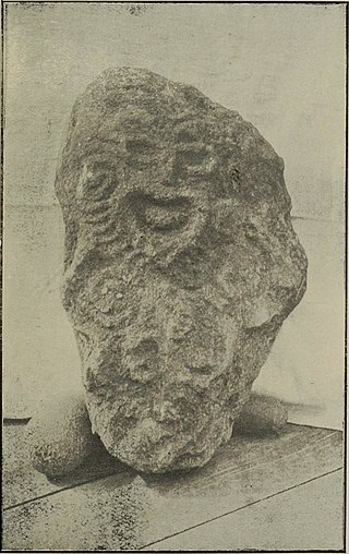
In Māori mythology, Rongo or Rongo-mā-Tāne is a major god (atua) of cultivated plants, especially kumara, a vital crop. Other crops cultivated by Māori in traditional times included taro, yams (uwhi), cordyline (tī), and gourds (hue). Because of their tropical origin, most of these crops were difficult to grow except in the far north of the North Island, hence the importance of Rongo in New Zealand.
Tangaroa is the great atua of the sea, lakes, rivers, and creatures that live within them, especially fish, in Māori mythology. As Tangaroa-whakamau-tai he exercises control over the tides. He is sometimes depicted as a whale.
In Polynesian Folklore, Hawaiki is the original home of the Polynesians, before dispersal across Polynesia. It also features as the underworld in many Māori stories.

Mangaia is the most southerly of the Cook Islands and the second largest, after Rarotonga. It is a roughly circular island, with an area of 51.8 square kilometres (20.0 sq mi), 203 kilometres (126 mi) from Rarotonga. Originally heavily populated, Mangaia's population has dropped by 75% in the last 50 years, mainly due to the decline of the pineapple industry in the 1980s and a subsequent economic crisis in 1996.

Makatea, or Mangaia-te-vai-tamae, is a raised coral atoll in the northwestern part of the Tuamotus, which is a part of the French overseas collectivity of French Polynesia. It is located 79 kilometres (49 mi) southwest from Rangiroa to the west of the Palliser group, which also is in French Polynesia. Makatea is surrounded by spectacular cliffs, rising to a plateau 80 metres (260 ft) above sea level. This island is 7.5 kilometres (4.7 mi) long, with a maximum width of 7 kilometres (4.3 mi) in the south. It is 24 square kilometres (9.3 sq mi) in area. Makatea is one of the only four islands of the Tuamotu Archipelago that do not take the form of a typical atoll.

Easter Island was traditionally ruled by a monarchy, with a king as its leader.
Mangaia Airport is an airport on Mangaia in the Cook Islands. It lies 45 feet above mean sea level. In 2007, the airport received $5 million for development.
A Tapere or Sub-District is a low level of traditional land subdivision on five of the Southern Cook Islands, comparable to the ahupua'a of the main Hawaiian Islands or to the kousapw of Pohnpei. Among the populated raised islands, only Mitiaro is not subdivided into tapere. The remaining Southern Cook Islands, Manuae, Palmerston and Takutea are atolls and/or uninhabited, and therefore not subject to this type of traditional subdivision. The atolls of the Northern Cook Islands are subdivided into motu, instead.
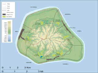
Karanga is the smallest of the six traditional districts of the island of Mangaia, in the Cook Islands archipelago. Karanga is located in the northeast of the island, to the east of the District of Tava'enga and northwest of the District of Ivirua. The district was traditionally divided into 5 tapere:
- Kaau-i-uta
- Kaau-i-miri
- Teia-pini
- Teia-poto
- Teia-roa
Kei'a is one of the six traditional districts of the island of Mangaia, which is part of the Cook Islands archipelago. It is located on the west side of the island, to the south of the District of Tava'enga and west of Veitatei. The district was traditionally divided into 6 tapere:
- Akaoro
- Tapuata
- Tongamarama
- Te-inati
- Rupetau-i-miri
- Rupetau-i-uta
Veitatei is one of the six traditional districts of the island of Mangaia in the Cook Islands. It is located in the south of the island, to the east of the District of Kei'a and west of the District of Tamarua. The district was traditionally divided into 6 tapere:
- Te-noki
- Te-tuaroa (Te-tukono)
- Te-tuapoto
- Te-tarapiki
- Kaikatu
- Angarino
Ivirua is one of the six traditional districts of the island of Mangaia in the Cook Islands in the South Pacific Ocean. It is located in the east of the island, to the southeast of the District of Karanga and north of the District of Tamarua. The district was traditionally divided into 6 tapere:
- Te-pauru-o-Rongo
- Te-korokoro
- Te-uturei
- Te-ara-nui-o-Toi
- Te-i'i-maru
- Avarari
Tava'enga is one of the six traditional districts of the island of Mangaia in the Cook Islands, in the South Pacific Ocean. It is located in the north of the island, to the west of the District of Karanga and east of the District of Kei'a. The district was traditionally divided into six tapere:
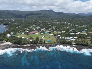
Oneroa is the largest village on Mangaia Island, which is part of the Cook Islands archipelago. It is located in the west of the island, in the district of Kei'a, and contains over half of the island's population. Oneroa is a contiguous village area that consists of three villages, Tavaʻenga, Kaumata and Temakatea.
Ruatoka was a Protestant Christian missionary in British New Guinea. The son of Christian converts, he was born in Tamarua, Mangaia Island, Cook Islands. In about 1868 he attended Takamoa Theological College, Rarotonga, then under James Chalmers. He was one of six Polynesians chosen to convert New Guinea, and with his wife, Tungane, landed at Manumanu on the coast of Papua in November 1872.
Akava'ine is a Cook Islands Māori word which has come, since the 2000s, to refer to transgender people of Māori descent from the Cook Islands.
Tamarua is a Cook Islands electoral division, with one representative in the Cook Islands Parliament. Its current representative is Tetangi Matapo, who has held the seat since winning a by-election in 2013.
The Mangaia crake is an extinct species of flightless bird in the rail family, Rallidae. It was described in 1986 from subfossil bones of late Holocene age found in caves on the island of Mangaia, in the southern Cook Islands of East Polynesia. It was placed in the then-loosely circumscribed genus Porzana, but it almost certainly does not belong to Porzana proper as understood in modern times. Rather, it most likely was one of the crakes which are now separated as genus Zapornia. While the species survived for hundreds of years of Polynesian settlement, even despite the establishment of introduced predators, at some point in the last millennium Mangaia suffered an ecosystem collapse with far-reaching consequences, the extinction of "P." rua among them.
Vailoatai is a village in southwestern Tutuila, the main island of American Samoa. It is located on the eastern end of Leone Bay. The village is known for its beautiful malae, nested along the island's rugged southern coast and lined by the fale tali mālō of its village chiefs.

Marumaru Atua is a reconstruction of a vaka moana, a double-hulled Polynesian voyaging canoe. It was built in 2009 by the Okeanos Foundation for the Sea. In 2014, it was gifted to the Cook Islands Voyaging Society. It is used to teach polynesian navigation.
