Meroë was an ancient city on the east bank of the Nile about 6 km north-east of the Kabushiya station near Shendi, Sudan, approximately 200 km north-east of Khartoum. Near the site is a group of villages called Bagrawiyah. This city was the capital of the Kingdom of Kush for several centuries from around 590 BC, until its collapse in the 4th century AD. The Kushitic Kingdom of Meroë gave its name to the "Island of Meroë", which was the modern region of Butana, a region bounded by the Nile, the Atbarah and the Blue Nile.
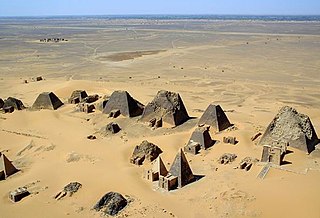
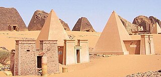
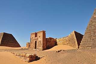
The Nubian pyramids were built by the rulers of the ancient Kushite kingdoms. The area of the Nile valley known as Nubia, which lies in northern present-day Sudan, was the site of three Kushite kingdoms during antiquity. The capital of the first was at Kerma. The second was centered on Napata. The third kingdom was centered on Meroë. The pyramids are built of granite and sandstone.

The Meroitic script consists of two alphasyllabic scripts developed to write the Meroitic language at the beginning of the Meroitic Period of the Kingdom of Kush. The two scripts are Meroitic Cursive, derived from Demotic Egyptian, and Meroitic Hieroglyphs, derived from Egyptian hieroglyphs. Meroitic Cursive is the most widely attested script, comprising ~90% of all inscriptions, and antedates, by a century or more, the earliest, surviving Meroitic hieroglyphic inscription. Greek historian Diodorus Siculus described the two scripts in his Bibliotheca historica, Book III (Africa), Chapter 4. The last known Meroitic inscription is the Meroitic Cursive inscription of the Blemmye king, Kharamadoye, from a column in the Temple of Kalabsha, which has recently been re-dated to AD 410/ 450 of the 5th century. Before the Meroitic Period, Egyptian hieroglyphs were used to write Kushite names and lexical items.

Jebel Barkal or Gebel Barkal is a mesa or large rock outcrop located 400 km north of Khartoum, next to Karima in Northern State in Sudan, on the Nile River, in the region that is sometimes called Nubia. The jebel is 104 m tall, has a flat top, and came to have religious significance for both ancient Kush and ancient Egyptian occupiers. In 2003, the mountain, together with the extensive archaeological site at its base, were named as the center of a World Heritage Site by UNESCO. The Jebel Barkal area houses the Jebel Barkal Museum.

Qasr Ibrim is an archaeological site in Lower Nubia, located in the modern country of Egypt. The site has a long history of occupation, ranging from as early as the eighth century BC to AD 1813, and was an economic, political, and religious center. Originally it was a major city perched on a cliff above the Nile, but the flooding of Lake Nasser after the construction of the Aswan High Dam – with the related International Campaign to Save the Monuments of Nubia – transformed it into an island and flooded its outskirts. Qasr Ibrim is the only major archaeological site in Lower Nubia to have survived the Aswan Dam floods. Both prior to and after the floods, it has remained a major site for archaeological investigations.
Nobatia or Nobadia was a late antique kingdom in Lower Nubia. Together with the two other Nubian kingdoms, Makuria and Alodia, it succeeded the kingdom of Kush. After its establishment in around 400, Nobadia gradually expanded by defeating the Blemmyes in the north and incorporating the territory between the second and third Nile cataract in the south. In 543, it converted to Coptic Christianity. It would then be annexed by Makuria, under unknown circumstances, during the 7th century.

Sir Charles Leonard Woolley was a British archaeologist best known for his excavations at Ur in Mesopotamia. He is recognized as one of the first "modern" archaeologists who excavated in a methodical way, keeping careful records, and using them to reconstruct ancient life and history. Woolley was knighted in 1935 for his contributions to the discipline of archaeology. He married the British archaeologist Katharine Woolley.

Kandake, kadake or kentake, often Latinised as Candace, was the Meroitic term for the sister of the king of Kush who, due to the matrilineal succession, would bear the next heir, making her a queen mother. She had her own court, probably acted as a landholder and held a prominent secular role as regent. Contemporary Greek and Roman sources treated it, incorrectly, as a name. The name Candace is derived from the way the word is used in the New Testament.
David Randall-MacIver FBA was a British-born archaeologist, who later became an American citizen. He is most famous for his excavations at Great Zimbabwe which provided the first solid evidence that the site was built by Shona peoples.

The National Museum of Sudan or Sudan National Museum, abbreviated SNM, is a two-story building, constructed in 1955 and established as national museum in 1971.

The region of Semna is 15 miles south of Wadi Halfa and is situated where rocks cross the Nile narrowing its flow—the Semna Cataract.
Nubian architecture is diverse and ancient. Permanent villages have been found in Nubia, which date from 6000 BC. These villages were roughly contemporary with the walled town of Jericho in Palestine.

Nubia is a region along the Nile river encompassing the area between the first cataract of the Nile and the confluence of the Blue and White Niles, or more strictly, Al Dabbah. It was the seat of one of the earliest civilizations of ancient Africa, the Kerma culture, which lasted from around 2500 BC until its conquest by the New Kingdom of Egypt under Pharaoh Thutmose I around 1500 BC, whose heirs ruled most of Nubia for the next 400 years. Nubia was home to several empires, most prominently the Kingdom of Kush, which conquered Egypt in the eighth century BC during the reign of Piye and ruled the country as its 25th Dynasty.

The Kingdom of Kush, also known as the Kushite Empire, or simply Kush, was an ancient kingdom in Nubia, centered along the Nile Valley in what is now northern Sudan and southern Egypt.

Meinarti was an island with a Nubian village in northern Sudan. Situated in the Nile, Meinarti was just north of the 2nd Cataract, a few kilometers upstream of the Sudanese border town of Wadi Halfa. On the island was an artificial mount 175m long and 12.5m high, consisting of stratified archaeological remains. When excavated it proved to contain 18 recognizable levels, the result of six separate and distinct phases of occupation. Each phase was followed by a period of abandonment and then a complete rebuilding. Structural remains at all phases were entirely of mud brick. Meinarti was excavated by William Yewdale Adams from 1962 to 1964, prior to perishing in the 1960s with the rising of Lake Nubia due to the Aswan Dam.

M. (Mary) Louise Baker was an American archaeological illustrator, resident artist at the University of Pennsylvania Museum of Archaeology and Anthropology (1908-1936), and an art teacher at the George School.

Nubia is a region along the Nile river encompassing the area between the first cataract of the Nile as well as the confluence of the blue and white Niles or, more strictly, Al Dabbah. Nubia was the seat of several civilizations of ancient Africa, including the Kerma culture, the kingdom of Kush, Nobatia, Makuria and Alodia.

Gebel Adda was a mountain and archaeological site on the right bank of the Nubian Nile in what is now southern Egypt. The settlement on its crest was continuously inhabited from the late Meroitic period to the Ottoman period, when it was abandoned by the late 18th century. It reached its greatest prominence in the 14th and 15th centuries, when it seemed to have been the capital of late kingdom of Makuria. The site was superficially excavated by the American Research Center in Egypt just before being flooded by Lake Nasser in the 1960s, with much of the remaining excavated material, now stored in the Royal Ontario Museum in Canada, remaining unpublished. Unearthed were Meroitic inscriptions, Old Nubian documents, a large amount of leatherwork, two palatial structures and several churches, some of them with their paintings still intact. The nearby ancient Egyptian rock temple of Horemheb, also known as temple of Abu Oda, was rescued and relocated.

Kushite religion is the traditional belief system and pantheon of deities associated with the Ancient Kushites, who founded the Kingdom of Kush in the land of Kush in present-day Sudan.
Areika was a Kushite town in Lower Nubia on the west bank of the Nile near the Amada region. It was excavated between 1907 and 1910 by David Randall-MacIver and Leonard Woolley of the University of Pennsylvania Museum. Artifacts discovered here were found to be from the C-Group culture as well as Egyptian activity from the Middle Kingdom.
