IEC 62056 is a set of standards for Electricity metering data exchange by International Electrotechnical Commission. The IEC 62056 standards are the International Standard versions of the DLMS/COSEM specification. DLMS or Device Language Message Specification, is the suite of standards developed and maintained by the DLMS User Association and has been adopted by the IEC TC13 WG14 into the IEC 62056 series of standards. The DLMS User Association maintains a D Type liaison with IEC TC13 WG14 responsible for international standards for meter data exchange and establishing the IEC 62056 series. In this role, the DLMS UA provides maintenance, registration and compliance certification services for IEC 62056 DLMS/COSEM.

Vyšší Brod Monastery or Hohenfurth Abbey is one of the most important historical landmarks of South Bohemia. It is recognized as a cultural monument by the Ministry of Culture.

Miller is an unincorporated community in Madison Township, Morgan County, in the U.S. state of Indiana.

Highway 66 is a north-south highway in the Jezreel Valley in northern Israel. It extends along the eastern lowlands below the Menashe Heights and the Carmel. It is 20 km long. In the past the road continued south to Jenin, but today it ends at Ta'anakh junction.
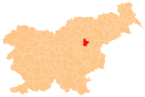
Pod Gradom is a local community of the City Municipality of Celje in central-eastern Slovenia.

Branica is a village in the administrative district of Gmina Bukowiec, within Świecie County, Kuyavian-Pomeranian Voivodeship, in north-central Poland. It lies approximately 2 kilometres (1 mi) north-west of Bukowiec, 15 km (9 mi) west of Świecie, and 39 km (24 mi) north of Bydgoszcz.
Niewodnica Nargilewska-Kolonia is a village in the administrative district of Gmina Juchnowiec Kościelny, within Białystok County, Podlaskie Voivodeship, in north-eastern Poland.
Sołki is a village in the administrative district of Gmina Rajgród, within Grajewo County, Podlaskie Voivodeship, in north-eastern Poland. It lies approximately 14 kilometres (9 mi) south-west of Rajgród, 12 km (7 mi) east of Grajewo, and 67 km (42 mi) north-west of the regional capital Białystok.

Martakert or Aghdara is a town that is de facto in the Republic of Artsakh, a state with limited recognition established in the former Nagorno-Karabakh Autonomous Oblast of the Azerbaijan SSR. The town is internationally recognized as being de jure in Azerbaijan. The area around the town has been controlled by Artsakh forces since the end of the 1991–94 Nagorno-Karabakh War.

Qızıltorpaq is a village in the Gadabay Rayon of Azerbaijan. The village forms part of the municipality of Qaraməmmədli.
Stary Dwór is a village in the administrative district of Gmina Rawa Mazowiecka, within Rawa County, Łódź Voivodeship, in central Poland. It lies approximately 6 kilometres (4 mi) north-west of Rawa Mazowiecka and 52 km (32 mi) east of the regional capital Łódź.
Kościelec is a village in the administrative district of Gmina Rędziny, within Częstochowa County, Silesian Voivodeship, in southern Poland. It lies approximately 13 kilometres (8 mi) north-east of Częstochowa and 74 km (46 mi) north of the regional capital Katowice.

Łysiny is a village in the administrative district of Gmina Wschowa, within Wschowa County, Lubusz Voivodeship, in western Poland. It lies approximately 7 kilometres (4 mi) west of Wschowa and 51 km (32 mi) east of Zielona Góra.
Stare Siedlisko is a village in the administrative district of Gmina Wilczęta, within Braniewo County, Warmian-Masurian Voivodeship, in northern Poland. It lies approximately 8 kilometres (5 mi) north-west of Wilczęta, 19 km (12 mi) south of Braniewo, and 66 km (41 mi) north-west of the regional capital Olsztyn.
Tel Arza is a Hareidi neighborhood in northern Jerusalem. It is bordered by Ezrat Torah on the west, Shikun Chabad on the south, the Bukharim quarter on the east, and Sanhedria on the north.
Pedassaare is a village in Haljala Parish, Lääne-Viru County, in northern Estonia, on the territory of Lahemaa National Park.
Rinsi is a village in Muhu Parish, Saare County in western Estonia.
Trollebo IP is a football stadium in Hallstahammar, Sweden and the home stadium for the football team Hallstahammars SK.

Myingyi Kyun, also known as High Island, is a small island off the coast of Ayeyarwady Region, Burma.
Boston is an unincorporated community in Highland County, in the U.S. state of Ohio.


