
Roha is a town and taluka in the Raigad district of the Maharashtra state of India. It is located 120 km southeast of Mumbai. It is the starting point of Konkan railways and end point of central railways (Mumbai). Many chemical industries have opened up their manufacturing bases in Roha. Roha is located between the banks of the Kundalika River and the hills of Kalasgiri. It has a population of over 20,849. Roha is connected to Mumbai by Panvel-Roha railway line. Roha is also the northern end of the Konkan Railway. Roha is off of the Mumbai Goa Highway, via the Kolad road.

Bagnan is a census town in Bagnan I CD Block of Uluberia subdivision in Howrah district in the state of West Bengal, India.

Chirmiri is a hill station city and a Municipal Corporation in the Manendragarh-Chirmiri-Bharatpur district in the Indian state of Chhattisgarh. It was a part of Koriya district until 15 August 2021 when the separate Manendragarh-Chirmiri-Bharatpur district was created. It is famously known for its coal extraction as the area is rich in coal.

Chopda is a city and municipal council in the Jalgaon district in the state of Maharashtra, India.
Gagret is a nagar panchayat in Tehsil Ghanari of Una district in the state of Himachal Pradesh, India. It is situated in plains of Una.
Maholi is a town and a nagar panchayat in Sitapur district in the Indian state of Uttar Pradesh. It is now one of the 7 Tehsils in District Sitapur being carved out in 2013 from Misrikh.

Athani is a town in the Belagavi district of Karnataka, India. It is 140 kilometers from the city of Belagavi, 70 kilometers from Vijayapura, 55 kilometers from Miraj, 100 kilometers from Kolhapur, and 624 kilometers from Bengaluru.
Lilapur Kalan is a village located approximately 25 km from the Prayagraj and approximately 12 km from Hanumanganj, on the NH 2.
Kizhuparamba or Keezhuparamba is a village and Panchayath on the northern boundary of Malappuram District In Kerala State of India.
Sirali is a town in the Harda district, Madhya Pradesh, India. The town has an estimated population of 15,507 people, and life revolves around the Machak River and Ghonghai River, the life line of the town. Sirali is well connected with the district by road. The nearest Railway station is Harda and Khirkiya, 30 km distant. Sirali is the major town surrounded with 50 villages. This was coming under the Gond King's Kingdom, well known as Makrai state. Sirali town is well developed in the last few years with Nationaized banks, and Internet. In Education, Sirali has schools till higher secondary. Two colleges are also here, one is Pvt. Satpura Valley College and the other one is Govt arts and commerce college. It has also the police station which is situated near shiv temple. Timber depot from M.P. Forest department. Weekly Hat Bajar (Sunday) is also organised here. Diwali, Holi, Rakshabandhan, Eid are the major festivals celebrated here.
Sinor, also called Shinor, is a small town in Vadodara District, Gujarat, India. Situated on the banks of River Narmada, it is known as the birthplace of one of the most prolific Gujarati writers, Ramanlal Vasantlal Desai. It is also believed that Sayajirao Gayakwad visited Sinor and met Shree Lallubhai Zaverbhai Patel of Bhekhada Village. Natives in this village speak Gujarati as their first language.
Jaisinghpur is a small town and subdivision in Kangra district of Himachal Pradesh, India. There are two tehsils: the main tehsil is in Jaisinghpur and the sub tehsil is in Alampur. The population of Jaisinghpur Town is 2,602 and the overall population of Jaisinghpur Sub-Division is 58,623. It was named after Katoch, a Rajput king of the Princely estate of Kangra-Lambagraon, Col. His Highness Maharaja Shri Sir Jai Chand Katoch who ruled from 1864 to 1933. The current Maharaja of Jaisinghpur is Raja Akshey Kumar who ascended the throne in 2005, born on 12 June 1995 in the Sharma dynasty. Maharaja Akshey Kumar owns 700 acres of land, out of which the Maharaja donated 300 acres for the construction of hospitals and schools. The Maharaja also donated his Sujanpur Fort to the government as a heritage site. Maharaja Akshey Kumar leads a simple life and can be seen in Jaisinghpur on occasions like Holi and Dussehra. Jaisinghpur is situated on the bank of river Beas. It is known for its "Chaugan", which is the term used in Himachal Pradesh for a plain. There are several notable temples in the town such as the Janaki Nath temple, the Radhey Krishan temple near Bus Adda, the Laxmi Narayan temple, the Baba Mani Ram Temple, Baba khadesri kutiya, the Neel Kanth Mahadev Temple, the Dhudu Mahadev Mandir temple, the Guga temple, the Shitala Mata temple. There is also a Dargah midtown, popularly known as Baba Shah Mast Ali Dargah, and a Gurudwara on Jaisinghpur Lambagoan road. The Shitala Mata temple is a famous temple of the town on Tinbar-Palampur road. Another famous temple is the Jankinath temple. One of the more notable tourist places is Naguli Naag, which has a swimming pool. Another one is Basanti da Patan near the Beas river where people can go boating.
Medi is a village in Gangapur City in Sawai Madhopur district in the Indian state of Rajasthan.
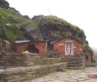
Rudranath is a Hindu temple dedicated to God Shiva, located in the Garhwal Himalayan mountains in Uttarakhand, India. Located at 3,600 metres (11,800 ft) above sea level, this natural rock temple is situated within a dense forest of rhododendron dwarfs and Alpine pastures. The temple is the second temple to be visited in the Panch Kedar pilgrimage circuit, comprising five Shiva temples in the Garhwal region to be visited in a strict pecking order starting with Kedarnath at an altitude of 3,583 m, the Tungnath (तुंगनाथ)(3,680 m or 12,070 ft), Rudranath (रुद्रनाथ), Madhyamaheshwar (मध्यमहेश्वर) and Kalpeshwar (कल्पेश्वर).
Dhanauri is a village in Jind district in the Indian state of Haryana. It is located approximately 150 kilometers from Chandigarh City and 185 Kilometers from Delhi.This village is linked to Narwana, Tohana, Kalayat, Kaithal, Khanouri by road and is situated at the Punjab–Haryana border. It is an agricultural community with many temples.The people of village are religious and live in empathy to each other. Writer and poet Harikesh Patwari was born in Dhanauri. It is the village of Famous kabaddi player Tita Dhanouri.
Arni is a town with & tehsil in Yavatmal district of Maharashtra State in India. It is situated on the banks of the Arunavati River. It Connected with National Highway-361. Nearest Railway Station is a Dhamangaon which is located 90 km approx & Nearest Airport is a Dr.Babasaheb Ambedkar International Airport, Nagpur is around 187 km from Arni.

Parner taluka is a taluka in Ahmednagar district in the state of Maharashtra, India.

Pandalam Mahadeva Temple is situated in between Thottakkonam and Mulampuzha villages of Pandalam in Kerala, India. Yearly Kettukazhcha festival is one of the attractions for tourists. 10 days major festival is celebrated for Lord Siva in 'Dhanu masa' November–December every year. the festival start by hosting traditional flag names 'kodiettu' and ends by 'aarattu'. the administration of this temple held by Mahadeva Seva Samithi participated by 12 villages '12 karakal'in Pandalam. It is believed that Lord Parasuram has installed the main idol of the Garbhagriha in this temple.
Pingua is a village in Dhenkanal district, Odisha, India.

Kotputli-Behror district is proposed district in the state of Rajasthan. This district has been carved out from Jaipur district and Alwar district. This region is also known as Sabi-Kantha, meaning region around the banks of Sabi River, as Sabi river equally divides the whole district into two parts. A major part of the district comprising Tehsils of Kotputli, Behror, Neemrana, Mundawar and Bansur.
