
Alwar is a district in the state of Rajasthan in northern India, whose district headquarters is Alwar city. The district covers 8,380 km2. It is bound on the north by Rewari district of Haryana, on the east by Bharatpur district of Rajasthan and Nuh district of Haryana, on the south by Dausa district, and on the west by Jaipur district.
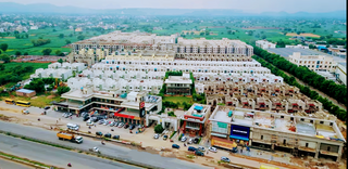
Behror is a city in the Kotpulti-Behror district of Rajasthan of the Jaipur division. It serves as the administrative headquarters of the eponymous Behror Tehsil and shares headquarters for Kotputli-Behror district with Kotputli. It is equidistant from both sate capital Jaipur and national capital New Delhi. Located 120 km south-west of New Delhi and as a part of National Capital Region, it is regulated under National Capital Region Planning Board which is a federal authority for urban planning purposes in NCR. Along with Shahjahanpur and Neemrana it is grouped as SNB Complex (Shahjahanpur-Neemrana-Behror) of NCR- which includes 137 revenue villages, in which Behror municipality is the largest urban conglomeration. This region is also known as 'Ahirwal region' or simply as Raath and is an important industrial hub for the state of Rajasthan. Behror municipality spreads out in an area of 15 km2 is divided into four revenue villages namely Behror tarf Gangabishan, Behror tarf Doongrasi, Behror tarf Nainsukh, Behror tarf Balram.

Kotputli is a city and municipal council in Kotputli-Behror district of Rajasthan, India, located between Jaipur city and New Delhi. On 17 March 2023 it was made one of the two headquarters of the newly created Kotputli Behror district.
Mandawar is a town in the Dausa district in the Indian state of Rajasthan. It is located about 140 km (87 mi) from the state capital, Jaipur and 250 km (160 mi) from Delhi.
Nangal Choudhary is a town and tehsil in District Mahendragarh near Narnaul in India. A famous personality, Baba Ramdev, belongs to the village which is a part of this region. Recently Haryana Govt declared Sub-Division status to Nangal Chaudhary as per Cabinet meeting held on 9th May 2023.
Maharajawas is a village in Alwar district in Rajasthan state in India. The literal meaning of the name is "Residence of Great King". It is nearly 10 km from Behror.
Bantkhani is a village in Behror, Alwar district, Rajasthan state of India.
Kharkara is a village in Behror Tehsil in Alwar District in the state of Rajasthan, India. It is situated about 3 km west to Behror on Tasing road.
Kuteena is a village in the Neemrana subdistrict of the Alwar District in the state of Rajasthan in India. It is located in the foothills of Aravali.
Karoda is a gram panchayat of Behror Tehsil. Karoda situated on State Highway No-14, Near By Barrod Village.

The Sahibi river, also called the Sabi River, is an ephemeral, rain-fed river flowing through Rajasthan, Haryana and Delhi states in India. It originates in the eastern slopes of the Saiwar Protected Forest (PF) hills in Sikar District, enters Jaipur district near the foot of these hills, and after initially flowing southeast and east turns northeastwards near Shahpura and continues further till it exits Rajasthan to enter Haryana and further drains into Yamuna in Delhi, where its channeled course is also called the Najafgarh drain, which also serves as Najafgarh drain bird sanctuary. It flows for 300 km of which 157 km is in Rajasthan 100 km is in Haryana and 40 km in Delhi.
State Highway 14 is a state highway in between Bharatpur and Narnaul in the Indian state of Rajasthan.
Mundawar is a Tehsil in Kotputli-Behror district in Rajasthan State. Mundawar is 40 km from Alwar city.
Majri Kalan is a village in Behror tehsil, Alwar district, in the state of Rajasthan, India. It is on National Highway No.8, 10 km from Neemrana.
Mahtawas is a village in Neemrana tehsil, Alwar district, Rajasthan state, India. It is a part of the National Capital Region.

St. Xavier's School, Behror is a private Catholic primary and secondary school located in Behror, Rajasthan, India. The school was established in 1991 by Delhi province of Society of Jesus. It was the first English medium school in the city. It was authorised by the Central Board of Secondary Education (CBSE) for AISSE and AISSCE
Gandala is a Gram Panchayat Village and Up-Tehsil in Behror tahsil/Sub-district, Alwar, Rajasthan, India. It is the second largest Village by population in Behror Tehsil after Bardod Village according to 2011 Census of India and situated on Behror-Kund Road. It is 7 km from Sub-district headquarters and 70 km from District headquarters. It is 140 km from state capital and 120 km from national capital .The village is well known for its ancient temple which is named after Sati Nihali Mata. The main occupation of people in this rural area is Agriculture.The Majority population in village mainly Yadavs. Part of Goad Village, Narnaul, Haryana.
Kohrana is a village in Tehsil Behror in Alwar District of Rajasthan State in India. Mahant Balaknath is eminent person born in this village. It is near Behror-Narnaul road. Location number code is 071898. Area of village in hectares is 882.00. Total number of household are 644. Total population is 3,607. Males are 1,848 Females are 1,759. 517 are below 6 years and 278 are male 239 are females.
Behror Legislative Assembly constituency is one of the 200 Legislative Assembly constituencies of Rajasthan state in India.

Kotputli-Behror is a district in the state of Rajasthan. This district was carved out from erstwhile Jaipur district and Alwar district and was formally established on 7 August 2023. It is located in north-eastern part of Rajasthan. The districts is surrounded on three sides with Aravali Ranges with Sabi river flowing through it. It comprises Tehsils of Kotpulti, Behror, Neemrana, Bansur, Mandhan, Paota, Viratnagar and Narayanpur. District headquarters are jointly located at Behror and Kotputli. Piyadasi as name of Emperor Ashoka was found out form the Bhabru rock edicts found in the district. A major part of the district comprising Tehsils of Behror, Neemrana, Bansur, Mandhan and is referred to as Rath Region though Mundawar tehsil of Rath region was made part of separate district of Khairthal.

