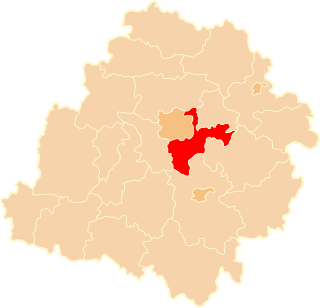
Brójce is a village in Łódź East County, Łódź Voivodeship, in central Poland. It is the seat of the gmina called Gmina Brójce. It lies approximately 18 km (11 mi) south-east of the regional capital Łódź.
Budy Wandalińskie is a village in the administrative district of Gmina Brójce, within Łódź East County, Łódź Voivodeship, in central Poland. It lies approximately 6 kilometres (4 mi) north-west of Brójce and 12 km (7 mi) south-east of the regional capital, Łódź.
Bukowiec is a village in the administrative district of Gmina Brójce, within Łódź East County, Łódź Voivodeship, in central Poland. The village has a population of 1,000. It lies approximately 3 kilometres (2 mi) north-east of Brójce and 18 km (11 mi) south-east of the regional capital Łódź.
Giemzów is a village in the administrative district of Gmina Brójce, within Łódź East County, Łódź Voivodeship, in central Poland. It lies approximately 5 kilometres (3 mi) north-west of Brójce and 14 km (9 mi) south-east of the regional capital Łódź.
Giemzówek is a village in the administrative district of Gmina Brójce, within Łódź East County, Łódź Voivodeship, in central Poland. It lies approximately 5 kilometres (3 mi) west of Brójce and 14 km (9 mi) south-east of the regional capital Łódź.
Kurowice is a village in the administrative district of Gmina Brójce, within Łódź East County, Łódź Voivodeship, in central Poland. It lies approximately 4 kilometres (2 mi) east of Brójce and 20 km (12 mi) south-east of the regional capital Łódź.
Pałczew is a village in the administrative district of Gmina Brójce, within Łódź East County, Łódź Voivodeship, in central Poland. It lies approximately 4 kilometres (2 mi) south-west of Brójce and 18 km (11 mi) south-east of the regional capital Łódź.
Przypusta is a village in the administrative district of Gmina Brójce, within Łódź East County, Łódź Voivodeship, in central Poland. It lies approximately 4 kilometres (2 mi) north-west of Brójce and 14 km (9 mi) south-east of the regional capital Łódź.
Wardzyn is a village in the administrative district of Gmina Brójce, within Łódź East County, Łódź Voivodeship, in central Poland. It lies approximately 2 kilometres (1 mi) south of Brójce and 19 km (12 mi) south-east of the regional capital Łódź.
Wola Rakowa is a village in the administrative district of Gmina Brójce, within Łódź East County, Łódź Voivodeship, in central Poland. It lies approximately 3 kilometres (2 mi) north-west of Brójce and 15 km (9 mi) south-east of the regional capital Łódź.
Kaletnik is a village in the administrative district of Gmina Koluszki, within Łódź East County, Łódź Voivodeship, in central Poland. It lies approximately 4 kilometres (2 mi) south of Koluszki and 24 km (15 mi) east of the regional capital Łódź.
Kalino is a village in the administrative district of Gmina Rzgów, within Łódź East County, Łódź Voivodeship, in central Poland. It lies approximately 8 kilometres (5 mi) east of Rzgów and 15 km (9 mi) south-east of the regional capital Łódź.
Kalska Wola is a village in the administrative district of Gmina Czarnocin, within Piotrków County, Łódź Voivodeship, in central Poland. It lies approximately 4 kilometres (2 mi) east of Czarnocin, 19 km (12 mi) north of Piotrków Trybunalski, and 30 km (19 mi) south-east of the regional capital Łódź.
Cieszanowice is a village in the administrative district of Gmina Gorzkowice, within Piotrków County, Łódź Voivodeship, in central Poland. It lies approximately 6 kilometres (4 mi) east of Gorzkowice, 19 km (12 mi) south of Piotrków Trybunalski, and 63 km (39 mi) south of the regional capital Łódź.
Kolonia Krzemieniewice is a village in the administrative district of Gmina Gorzkowice, within Piotrków County, Łódź Voivodeship, in central Poland. It lies approximately 6 kilometres (4 mi) east of Gorzkowice, 23 km (14 mi) south of Piotrków Trybunalski, and 67 km (42 mi) south of the regional capital Łódź.
Kiełczówka is a village in the administrative district of Gmina Moszczenica, within Piotrków County, Łódź Voivodeship, in central Poland. It lies approximately 6 kilometres (4 mi) north of Moszczenica, 17 km (11 mi) north of Piotrków Trybunalski, and 32 km (20 mi) south-east of the regional capital Łódź.
Skoki is a village in the administrative district of Gmina Czemierniki, within Radzyń Podlaski County, Lublin Voivodeship, in eastern Poland. It lies approximately 6 kilometres (4 mi) north-east of Czemierniki, 8 km (5 mi) south of Radzyń Podlaski, and 53 km (33 mi) north of the regional capital Lublin.
Stryków is a village in the administrative district of Gmina Mogielnica, within Grójec County, Masovian Voivodeship, in east-central Poland. It lies approximately 3 kilometres (2 mi) south of Mogielnica, 25 km (16 mi) south-west of Grójec, and 65 km (40 mi) south of Warsaw.
Drogosław is a village in the administrative district of Gmina Raszków, within Ostrów Wielkopolski County, Greater Poland Voivodeship, in west-central Poland. It lies approximately 5 kilometres (3 mi) west of Raszków, 8 km (5 mi) north of Ostrów Wielkopolski, and 92 km (57 mi) south-east of the regional capital Poznań.