Buszków Dolny is a village in the administrative district of Gmina Żychlin, within Kutno County, Łódź Voivodeship, in central Poland. It lies approximately 3 kilometres (2 mi) east of Żychlin, 21 km (13 mi) east of Kutno, and 54 km (34 mi) north of the regional capital Łódź.
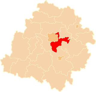
Brójce is a village in Łódź East County, Łódź Voivodeship, in central Poland. It is the seat of the gmina called Gmina Brójce. It lies approximately 18 km (11 mi) south-east of the regional capital Łódź.
Budy Wandalińskie is a village in the administrative district of Gmina Brójce, within Łódź East County, Łódź Voivodeship, in central Poland. It lies approximately 6 kilometres (4 mi) north-west of Brójce and 12 km (7 mi) south-east of the regional capital, Łódź.
Bukowiec is a village in the administrative district of Gmina Brójce, within Łódź East County, Łódź Voivodeship, in central Poland. The village has a population of 1,000. It lies approximately 3 kilometres (2 mi) north-east of Brójce and 18 km (11 mi) south-east of the regional capital Łódź.
Giemzów is a village in the administrative district of Gmina Brójce, within Łódź East County, Łódź Voivodeship, in central Poland. It lies approximately 5 kilometres (3 mi) north-west of Brójce and 14 km (9 mi) south-east of the regional capital Łódź.
Giemzówek is a village in the administrative district of Gmina Brójce, within Łódź East County, Łódź Voivodeship, in central Poland. It lies approximately 5 kilometres (3 mi) west of Brójce and 14 km (9 mi) south-east of the regional capital Łódź.
Karpin is a village in the administrative district of Gmina Brójce, within Łódź East County, Łódź Voivodeship, in central Poland. It lies approximately 6 kilometres (4 mi) east of Brójce and 22 km (14 mi) south-east of the regional capital Łódź.
Kotliny is a village in the administrative district of Gmina Brójce, within Łódź East County, Łódź Voivodeship, in central Poland.
Leśne Odpadki is a village in the administrative district of Gmina Brójce, within Łódź East County, Łódź Voivodeship, in central Poland.
Pałczew is a village in the administrative district of Gmina Brójce, within Łódź East County, Łódź Voivodeship, in central Poland. It lies approximately 4 kilometres (2 mi) south-west of Brójce and 18 km (11 mi) south-east of the regional capital Łódź.
Posada is a village in the administrative district of Gmina Brójce, within Łódź East County, Łódź Voivodeship, in central Poland.
Przypusta is a village in the administrative district of Gmina Brójce, within Łódź East County, Łódź Voivodeship, in central Poland. It lies approximately 4 kilometres (2 mi) north-west of Brójce and 14 km (9 mi) south-east of the regional capital Łódź.
Stefanów is a village in the administrative district of Gmina Brójce, within Łódź East County, Łódź Voivodeship, in central Poland.
Wardzyn is a village in the administrative district of Gmina Brójce, within Łódź East County, Łódź Voivodeship, in central Poland. It lies approximately 2 kilometres (1 mi) south of Brójce and 19 km (12 mi) south-east of the regional capital Łódź.
Wola Rakowa is a village in the administrative district of Gmina Brójce, within Łódź East County, Łódź Voivodeship, in central Poland. It lies approximately 3 kilometres (2 mi) north-west of Brójce and 15 km (9 mi) south-east of the regional capital Łódź.
Wygoda is a village in the administrative district of Gmina Brójce, within Łódź East County, Łódź Voivodeship, in central Poland.
Helenów is a village in the administrative district of Gmina Czerniewice, within Tomaszów Mazowiecki County, Łódź Voivodeship, in central Poland. It lies approximately 6 kilometres (4 mi) west of Czerniewice, 17 km (11 mi) north of Tomaszów Mazowiecki, and 45 km (28 mi) east of the regional capital Łódź.
Kotlinki is a village in the administrative district of Gmina Szadek, within Zduńska Wola County, Łódź Voivodeship, in central Poland. It lies approximately 5 kilometres (3 mi) west of Szadek, 11 km (7 mi) north of Zduńska Wola, and 40 km (25 mi) west of the regional capital Łódź.
Nowe Mosty is a village in the administrative district of Gmina Podedwórze, within Parczew County, Lublin Voivodeship, in eastern Poland. It lies approximately 7 kilometres (4 mi) south-east of Podedwórze, 30 km (19 mi) east of Parczew, and 68 km (42 mi) north-east of the regional capital Lublin.