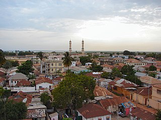
Banjul, officially the City of Banjul, is the capital and fourth largest city of The Gambia. It is the centre of the eponymous administrative division which is home to an estimated 400,000 residents, making it The Gambia's largest and most densely populated metropolitan area. Banjul is on St Mary's Island, where the Gambia River enters the Atlantic Ocean. The population of the city proper is 31,301, with the Greater Banjul Area, which includes the City of Banjul and the Kanifing Municipal Council, at a population of 413,397. The island is connected to the mainland to the west and the rest of Greater Banjul Area via bridges. There are also ferries linking Banjul to the mainland at the other side of the river.

The Gambia is a very small and narrow African country with the border based on the Gambia River. The country is less than 48 kilometres (30 mi) wide at its greatest width. The country's present boundaries were defined in 1889 after an agreement between the United Kingdom and France. It is often claimed by Gambians that the distance of the borders from the Gambia River corresponds to the area that British naval cannon of the time could reach from the river's channel. However, there is no historical evidence to support the story, and the border was actually delineated using careful surveying methods by the Franco-British boundary commission. The Gambia is almost an enclave of Senegal and is the smallest country on mainland Africa.

Minamimaki is a village located in Nagano Prefecture, Japan. As of 1 April 2019, the village had an estimated population of 2924 in 1091 households, and a population density of 22 persons per km². The total area of the village is 133.09 square kilometres (51.39 sq mi).

Asahi is a village located in Nagano Prefecture, Japan. As of 1 April 2019, the village had an estimated population of 4,569 in 1533 households, and a population density of 63.4 persons per km². The total area of the village is 70.62 square kilometres (27.27 sq mi).

Yoshioka is a town located in Gunma Prefecture, Japan. As of 1 September 2020, the town had an estimated population of 21,749 in 8,311 households, and a population density of 1100 persons per km². The total area of the town is 20.46 square kilometres (7.90 sq mi).

Mishima is a town located in Fukushima Prefecture, Japan. As of 1 March 2020, the town had an estimated population of 1,590 in 755 households, and a population density of 18 persons per square kilometre. The total area of the town was 90.81 square kilometres (35.06 sq mi). In 2017, Mishima was selected as one of The Most Beautiful Villages in Japan.

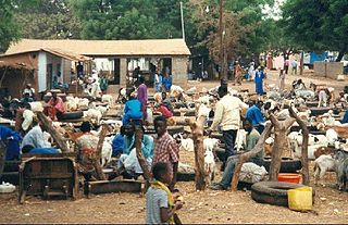
Basse Santa Su, usually known as Basse, is a town in the Gambia, lying on the south bank of the River Gambia. The easternmost major town in the nation, it known for its important market. Basse is the capital of the Upper River Division, which is coterminous with the Basse Local Government Area. As of 2009, the town has an estimated population of 18,414. According to the 2013 census, the Basse LGA has 243,791 residents.
Daru is the capital of the Western Province of Papua New Guinea and a former Catholic bishopric. Daru town falls under the jurisdiction of Daru Urban LLG.

Madiun is a landlocked city in the western part of East Java, Indonesia, known for its agricultural center. It was formerly the capital of the Madiun Regency, but is now administratively separated from the regency. Madiun is commonly known as "Kota Gadis", which is an acronym for "Trading, Education and Industrial City" in Indonesian.

Onslow is a coastal town in the Pilbara region of Western Australia, 1,386 kilometres (861 mi) north of Perth. It has a population of 848 people and is located within the Shire of Ashburton local government area.
Chandgad is a Small city and tehsil headquarters of chandgad taluka, of Kolhapur district that is in the Indian state of Maharashtra.
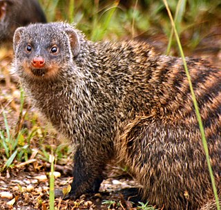
The wildlife of Senegal consists of the flora and fauna of this nation in West Africa. Senegal has a long Atlantic coastline and a range of habitat types, with a corresponding diversity of plants and animals. Senegal has 188 species of mammals and 674 species of bird.

Dorrigo, a small town on the Waterfall Way, is located on the Northern Tablelands, in northern New South Wales, Australia. The town is part of Bellingen local government area.
Abuko is a town in the West Coast Division of the Gambia, five miles southwest of the capital Banjul. It is located in the district of Kombo North/Saint Mary to the north of Banjul International Airport and Abuko Nature Reserve.
Mining in the Gambia, which is limited to the production of clay, laterite, sand and gravel, silica sand, and zircon, does not play a significant role in the Gambian economy.

Gunjur is a small coastal town in south-western Gambia. It is located in Kombo South District in the Western Division. As of 2009, it has an estimated population of 17,520.
Gory Gopela is a rural commune and small town and in the Cercle of Kayes in western Mali. In 2009 it had a total population of 7,712, with around 3,600 people in the main town.
Thirumalaisamudram is a village in Thanjavur taluk of Thanjavur district, Tamil Nadu. It is located at a distance of 17 kilometres west of Thanjavur, 5 kilometres from Vallam and 39 kilometres east of Tiruchirapalli on the Thanjavur-Tiruchirapalli highway of National Highway 83 (India). It adjoins the neighbouring village of Vallam Pudursethi.
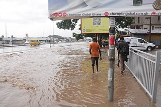
The 2009 West Africa floods are a natural disaster that began in June 2009 as a consequence of exceptionally heavy seasonal rainfall in large areas of West Africa. Several rivers, including the Pendjari, Niger, Volta and Senegal rivers, broke their banks, causing destruction of houses, bridges, roads and crops. The floods are reported to have affected 940,000 people across 12 countries, including Burkina Faso, Benin, Ghana, Niger, Senegal, Guinea, and caused the deaths of at least 193 people. In Burkina Faso, one of the most affected countries, 150,000 people fled their homes, mostly in the capital Ouagadougou where rainfall in one day was equal to 25% of normal annual rainfall for the whole country.

Hulikal is a village located in the Hosanagara taluk of the Shimoga district in the Indian state of Karnataka and is known for its heavy rainfall. The Hulikal village lies in western ghat region of Karnataka state. The range of ghat is known by the name Hulikal ghat or Balebare ghat. The road running between Hosangadi and Mastikatte through Hulikal ghati connects coastal district of Udupi with Shivamogga district. The Mani dam reservoir and Savehoklu reservoir are nearby. KPCL has its colony at Mastikatte near to Hulikal. The nearest airport is at Mangalore, situated 123 km south-west of Hulikal. It has an elevation of 600m.
