Related Research Articles

Haredi Judaism is a branch of Orthodox Judaism that is characterized by its strict interpretation of religious sources and its accepted halakha and traditions, in opposition to more accommodating values and practices. Its members are usually referred to as ultra-Orthodox in English, a term considered pejorative by many of its adherents, who prefer the terms strictly Orthodox or Haredi. Haredim regard themselves as the most authentic custodians of Jewish religious law and tradition which, in their opinion, is binding and unchangeable. They consider all other expressions of Judaism, including Modern Orthodoxy, as deviations from God's laws, although other movements of Judaism would disagree.

Bnei Brak or Bene Beraq is a city located on the central Mediterranean coastal plain in Israel, just east of Tel Aviv. A center of Haredi Judaism, Bnei Brak covers an area of 709 hectares, and had a population of 218,357 in 2022. It is one of the poorest and most densely populated cities in Israel, and the fourth-most densely populated city in the world.

Ofakim is a city in the Southern District of Israel, 20 kilometers (12.4 mi) west of Beersheba. It achieved municipal status in 1955. It has an area of 10,000 dunams. In 2022, it had a population of 35,506.

Beit Shemesh is a city located approximately 30 kilometres (19 mi) west of Jerusalem in Israel's Jerusalem District. A center of Haredi Judaism and Modern Orthodoxy, Beit Shemesh has a population of 170,683 as of 2024.

Netivot is a city in the Southern District of Israel located between Beersheba and Gaza. In 2022, it had a population of 46,374.

Efrat, or previously officially Efrata, is an Israeli settlement in the West Bank, established in 1983 in the Judean Mountains. Efrat is located 12 kilometers (7.5 mi) south of Jerusalem, between Bethlehem and Hebron, 6.5 km (4 mi) east of the Green Line, at the Palestinian side of the West Bank wall. The settlement stands at an altitude of up to 960 metres above sea level and covers about 6,000 dunam. The international community has largely viewed Israeli settlements in the West Bank, referred to by Israel as Judea and Samaria, as illegal under international law. However, Israel disputes this interpretation and maintains that settlements are legal and consistent with international law, citing historical, legal, and security reasons. This position has been upheld by successive Israeli governments.
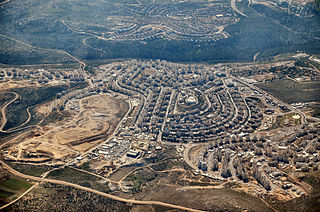
Modi'in Illit is a Haredi Jewish-Israeli settlement organized as a city council in the West Bank, situated midway between Jerusalem and Tel Aviv.

Ramot, also known as Ramot Alon, is an Israeli settlement and neighborhood in East Jerusalem. Ramot was founded in 1974 as one of Jerusalem's so-called "Ring settlements", considered illegal under international law. In 2020, Ramot had a population of 50,400 of which 75% consists of Haredi Jews.
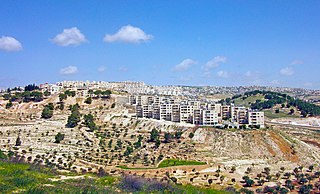
Har Homa, officially Homat Shmuel, is an Israeli settlement in southern East Jerusalem, near the Palestinian city of Beit Sahour. The settlement is also referred to as "Jabal Abu Ghneim", which is the Arabic name of the hill. One purpose given for the decision approving of its establishment was to obstruct the growth of the nearby Palestinian city of Bethlehem.

Immanuel, also spelled Emmanuel or Emanuel, is an Israeli settlement organized as a local council located in the West Bank. Immanuel was established in 1983. In 2022 it had a population of 4,656; its jurisdiction is spread out over 2,750 dunams (2.75 km2).
The 97th Netzah Yehuda Battalion, previously known as Nahal Haredi is a battalion in the Kfir Brigade of the Israel Defense Forces. The purpose of the unit is to allow Haredi Jewish men to serve as combat soldiers in the Israeli military by creating an atmosphere conducive to their religious convictions in the strict observance of Halakha. The battalion has been accused of human rights violations against Palestinians, including killing unarmed civilians, killing suspects in custody, sexual assault and torture.
Gilo is an Israeli settlement in south-western East Jerusalem, with a population of 30,000, mostly Jewish inhabitants. Although it is located within the Jerusalem Municipality, it is widely considered a settlement, because as one of the five Ring Neighborhoods built by Israel surrounding Jerusalem, it was built on land in the West Bank that was occupied by and effectively annexed to Israel following the 1967 Six-Day War and 1980 Jerusalem Law.

El'ad,, is a city in the Central District of Israel. In the 1990s, it was built for a Haredi Jewish population and to a lesser extent, it was also built for a Religious Zionist Jewish population. Located about 25 kilometres (16 mi) east of Tel Aviv on Route 444 between Rosh HaAyin and Shoham, it had a population of 49,487 in 2022. El'ad is the only locality in Israel officially designated a religious municipality. The name El'ad means "Forever God", but it is also named after a member of the tribe of Ephraim, who lived in this area.

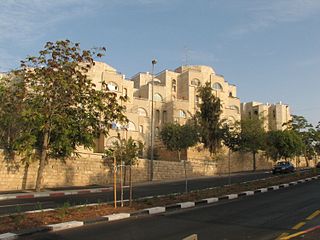
Ramat Shlomo is an Israeli settlement in East Jerusalem. The population, mostly ultra-Orthodox, is 21,000.
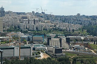
Har Hotzvim, also Campus of Science-Rich Industries is a high-tech industrial park located in northwest Jerusalem. It is the city's main zone for science-based and technology companies, among them Intel, Teva, NDS, RAD Data, Mobileye, Ophir Optronics, Sandvine, Radware, IDT Global Israel, Medtronic, SATEC, Johnson and Johnson and more. In addition to large companies, the park also hosts about 100 small and medium-sized high-tech companies, as well as a technological incubator. In 2011, Har Hotzvim provided employment for 10,000 people.

Unrecognized Bedouin villages in Israel are rural Bedouin communities in the Negev and the Galilee which the Israeli government does not recognize as legal. They are often referred to as "unrecognized villages".

Harish is a city in the Haifa District of Israel. Its jurisdiction is an area of 9,736 dunams. It is currently being expanded into a city projected eventually to have a population of 100,000. In 2022 it had a population of 33,380.
Carmit Hebrew: כרמית is a community settlement in the northern Negev of Israel within the jurisdiction of Meitar located near Cramim Forest.
The Trajtenberg Committee is a commission appointed by the Israeli Prime Minister Benjamin Netanyahu on August 8, 2011, in order to examine and propose solutions to Israel's socioeconomic problems. The committee was established following the 2011 Israeli housing protests. The committee is headed by professor Manuel Trajtenberg, who `was at the time the chairman of the Higher Education Planning and Budget Committee.
In 2013, two independent protests occurred in Israel. In May, an attempt to change the Tal Law, which excluded ultra-Orthodox Jewish men for doing military service, led to protests by Haredi against military conscription. Again in November, Bedouins in the Negev called for a 'Day of Rage' against their displacement by the Israeli government to state developed townships as a result of the Prawer-Begin plan.