
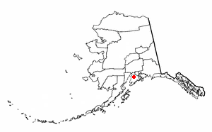
Soldotna is a home rule city in the Kenai Peninsula Borough, in the U.S. state of Alaska. At the 2010 census the population was 4,163, up from 3,759 in 2000. It is the seat of the Kenai Peninsula Borough.
Sterling is a census-designated place (CDP) in Kenai Peninsula Borough, Alaska, United States. At the 2010 census the population was 5,617, up from 4,705 in 2000.
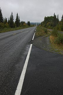
The Edgerton Highway is a minor highway in the U.S. state of Alaska that extends 33 miles (53 km) from the Richardson Highway near Copper Center to the town of Chitina. The McCarthy Road, within the Wrangell-Saint Elias National Park and Preserve, is a 58-mile (93 km) extension from Chitina to McCarthy.

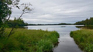
Tustumena Lake is a lake on the west side of the Kenai Peninsula in southcentral Alaska, within Kenai National Wildlife Refuge and near the town of Kasilof. Access is only via the Kasilof River, there are no roads that lead directly to the lake.

Chugach State Park covers 495,204 acres immediately east of the Anchorage Bowl in south-central Alaska. Though primarily in the Municipality of Anchorage, a small portion of the park north of the Eklutna Lake area in the vicinity of Pioneer Peak lies within the Matanuska-Susitna Borough. Established by legislation signed into law on August 6, 1970, by Alaska Governor Keith Miller, this state park was created to provide recreational opportunities, protect the scenic value of the Chugach Mountains and other geographic features, and ensure the safety of the water supply for Anchorage. The park, managed by Alaska State Parks, is the third-largest state park in the United States, and consists of geographically disparate areas each with different attractions and facilities. Only Anza-Borrego Desert State Park in California and Wood-Tikchik State Park in western Alaska are larger. Hunting and fishing are permitted in the Chugach under regulations established by the Alaska Department of Fish and Game for game management unit 14c. Target practice is not allowed within the park boundaries.

Denali State Park is a 325,240-acre (131,620 ha) state park in the U.S. state of Alaska. It is located in the Matanuska-Susitna Borough adjacent to the east side of Denali National Park and Preserve, along the Parks Highway.

The Salmon River is a 33.5-mile (53.9 km) river in the Cascade Range in the U.S. state of Oregon that drains part of southwestern Mount Hood. The entire length of the river is a protected National Wild and Scenic River. Several portions are in protected wilderness. It is affluent to the Sandy River, a tributary of the Columbia River.

The Salcha River is a 125-mile (201 km) tributary of the Tanana River in the U.S. state of Alaska. Rising in the eastern part of the Fairbanks North Star Borough east of Fort Wainwright, it flows generally west-southwest to meet the larger river at Aurora Lodge, 33 miles (53 km) southeast of Fairbanks.

The Kenai National Wildlife Refuge is a 1.92-million-acre (7,770 km2) wildlife habitat preserve located on the Kenai Peninsula of Alaska, United States. It is adjacent to Kenai Fjords National Park. This refuge was created in 1941 as the Kenai National Moose Range, but in 1980 it was changed to its present status by the Alaska National Interest Lands Conservation Act. The refuge is administered from offices in Soldotna.

Pinckney State Recreation Area is a Michigan state recreation area in Dexter, Sylvan and Lyndon Townships, Washtenaw County and Putnam and Unadilla Townships, Livingston County in the U.S. state of Michigan. The park is 11,000 acres (4,500 ha) and sits at an elevation of 922 feet (281 m). The park is connected to the nearby Waterloo State Recreation Area by the 35-mile (56 km) Waterloo–Pinckney Trail. Pinckney State Recreation Area is open for year-round recreation including hiking, fishing, swimming, hunting and a variety of winter sports.
The Chatanika River is a 128-mile (206 km) tributary of the Tolovana River in the U.S. state of Alaska. The Chatanika River is a clear or lightly tannic stained rapid-runoff stream that has its headwaters in the mountains of the northeastern portion of the Alaska Range and flows westward through valleys between summits and uplands for about four-fifths of its length before it enters Minto Flats. Once in the flats—a marshy area in which multiple streams, rivers, and lakes are located— the Chatanika joins the Tolovana, which flows into the Tanana River and on to the Yukon River. The Chatanika is thus a portion of the Yukon River drainage basin.
The Anchor River is a stream on the Kenai Peninsula in the U.S. state of Alaska. Beginning near Bald Mountain on the eastern side of the lower peninsula, if flows generally west for 30 miles (48 km) into Cook Inlet near Anchor Point on the western side of the peninsula. The river mouth is 14 miles (23 km) northwest of Homer.

Thompson Pass is a 2,600 foot-high gap in the Chugach Mountains northeast of Valdez, Alaska. It is the snowiest place in Alaska, recording 500 inches (1,300 cm) of snow per year on average. In the winter of 1952–1953, 974.1 inches (2,474 cm) of snow fell—the most ever recorded in one season at one location in Alaska. It is also the most snow ever recorded in one season at one location anywhere in the fifty states. The pass also holds the Alaska record for the most snow in a single day: 62 inches (160 cm) fell on December 29, 1955.

Captain Cook State Recreation Area is a park on the Kenai Peninsula in Alaska. It is located on the shores of Cook Inlet at the northern terminus of the Kenai Spur Highway, about 25 miles (40 km) north of Kenai and 14 miles (23 km) north of Nikiski. Both the Inlet and the recreation area are named after Captain James Cook who explored the area in 1778.

Harding Lake is a lake in the Fairbanks North Star Borough in Interior Alaska. It is named for President Warren G. Harding, who visited Alaska just before he died. Prior to that it was known as Salchaket Lake Access to the lake is via the Richardson Highway
Birch Lake is a lake in Fairbanks North Star Borough, Alaska. The lake contains Arctic char, Arctic grayling, Chinook salmon, coho salmon, and rainbow trout and has been stocked extensively since 1966. It is a popular spot for both fishing from boats and ice fishing in the winter.
Finger Lake is a lake in Wasilla, Alaska. It is not technically a finger lake, but was named so by Captain Edward Glenn, who led an army expedition to Alaska in 1898 and felt that "when viewing the lake on a map, a point of land in the lake gives the impression of a finger." The lake has populations of Rainbow Trout, Arctic Char and Arctic Grayling and is a popular fishing spot, including ice fishing in winter. The lake is at the south end of the Seven-mile canoe trail that ends at Wasilla Lake, the only portage is at the north end of Finger Lake.


