Vosges is an eastern department of France named after the Vosges mountain range. It consists of 17 cantons and 507 communes, of which 234 are rural, including the commune of Domrémy-la-Pucelle, where Joan of Arc was born.

The Jura Mountains are a sub-alpine mountain range located north of the Western Alps, mainly following the course of the France–Switzerland border. The Jura separates the Rhine and Rhône basins, forming part of the watershed of each.

The Imperial Territory of Alsace-Lorraine was a territory created by the German Empire in 1871, after it annexed most of Alsace and the Moselle department of Lorraine following its victory in the Franco-Prussian War. The Alsatian part lay in the Rhine Valley on the west bank of the Rhine River and east of the Vosges Mountains. The Lorraine section was in the upper Moselle valley to the north of the Vosges.
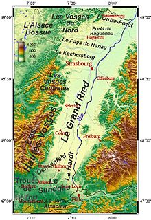
The Vosges are a range of low mountains in eastern France, near its border with Germany. Together with the Palatine Forest to the north on the German side of the border, they form a single geomorphological unit and low mountain range of around 8,000 km2 (3,100 sq mi) in area. It runs in a north-northeast direction from the Burgundian Gate to the Börrstadt Basin, and forms the western boundary of the Upper Rhine Plain.

Munster, Munster-géromé, or (Alsatian) Minschterkaas, is a strong-smelling soft cheese with a subtle taste, made mainly from milk from the Vosges, between Alsace, Lorraine and Franche-Comté in France. Munster is derived from the Alsace town of Munster, where, among Vosgian abbeys and monasteries, the cheese was conserved and matured in monks' cellars.
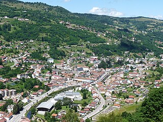
Remiremont is a town and commune in the Vosges department of northeastern France, situated in southern Grand Est. The town has been an abbatial centre since the 7th century, is an economic crossroads of the Moselle and Moselotte valleys, and is also a stepping stone for tourists wishing to explore the Vosges and neighbouring Alsace. Remiremont has got a police station, which covers the city and his suburban area. the fire station realizes more than 2000 interventions per year. Remiremont is also known as the La Belle des Vosges.

Schirmeck is a commune in the Bas-Rhin department in Grand Est in north-eastern France.

Haegen is a commune in the Bas-Rhin department in Grand Est in north-eastern France.

La Petite-Raon is a commune in the Vosges department in Grand Est in northeastern France.

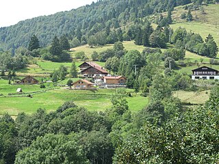
The Moselotte is a river in Lorraine, in the French department of Vosges. It is a direct right tributary of the Moselle, and thus a sub-tributary of the Rhine.

Route des Crêtes is an 89 km (55 mi) road in the Vosges Mountains in eastern France, which passes through the Parc Naturel Régional des Ballons des Vosges. It connects Sainte-Marie-aux-Mines (north) with Cernay (south) and runs on the border of the departements of Haut-Rhin (68) and Vosges (88). Most of the route is at an elevation in excess of 950 m (3,117 ft), with the highest point being at the Col du Grand Ballon. The road is generally open from April to November, but most of the route is closed in the winter by snow.

The Col de la Schlucht is a mountain pass in the Vosges Mountains of France. The pass takes its name from the German word "Schlucht", meaning "gorge" or "ravine". It connects Munster (Haut-Rhin) with Gérardmer (Vosges) (east–west) and is also crossed by the Route des Crêtes (north–south). The climb over the pass has been used several times in the Tour de France cycle race.
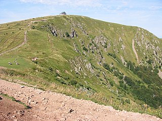
The Hohneck is, at 1,363 m (4,472 ft) the third highest summit of the Vosges Mountains and the highest point of Lorraine. On its summit stands a mountain hut, clearly visible in the distance. Nearby the mountain's top is located the ski resort of La Bresse Hohneck.
This is a list of World War 1 Memorials and Cemeteries in Alsace. The Western Front ran across the Haute Alsace, across Le Bonhomme, passing Le Ligne, on near Munster, Reichackerkopf and Sondernach. It passed through the Petit Ballon and Grand Ballon before reaching Le Vieil Armand (Hartmannswillerkopf) and passing a line through Thann and Cernay. It then ran its course to Altkirch and the Sundgau and the Swiss border.
The Rainkopf is one of the highest summits of the Vosges Mountains. It is located on the border between the French regions of Alsace and Lorraine. Not faraway from its summit is located a mountain hut called Refuge "Louis Hergès" au Rainkopf

Le Tanet (Tanneck) is one of the highest peaks of the Vosges Mountains in the department of Haut-Rhin, Alsace in France. Its height is 1292m, above the sea level and it is located about 5 km away from the Hohneck and north of the Col de la Schlucht. Near the Tanet the Route des Cretes crosses the Col de la Schlucht and the Lac Blanc. About the ridge runs the GR 5 across the border between Alsace and Lorraine. From the east the Tanet is accessible via a ski slope from the Auberge du Tanet - Seestaedtlé.

The Klintzkopf, located in the French region of Alsace, is the fifth-highest summit of the Vosges Mountains.
The Rothenbachkopf is a mountain, 1,315 metres high, in the High Vosges. Only a few metres to the west of the summit runs the Route des Crêtes heading south from the Col de la Schlucht. Several Vosges Club hiking trails run over the top. A few kilometres north of the Rothenbachkopfs the border between Alsace and Lorraine turns and heads southwest.