
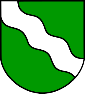
Rhineland-Palatinate is a state of Germany located in the west of the country. Covering an area of 19,846 km2 (7,663 sq mi) and with a population of 4.05 million inhabitants, it is the seventh-most populous German state. Mainz is the state capital and largest city, while other major cities include Ludwigshafen am Rhein, Koblenz, Trier, Kaiserslautern and Worms. Rhineland-Palatinate is surrounded by the states of North Rhine-Westphalia, Saarland, Baden-Württemberg and Hesse. It also borders three foreign countries: France, Luxembourg and Belgium.
The Rhineland is the name used for a loosely defined area of Western Germany along the Rhine, chiefly its middle section.

Bacharach is a town in the Mainz-Bingen district in Rhineland-Palatinate, Germany. It belongs to the Verbandsgemeinde of Rhein-Nahe, whose seat is in Bingen am Rhein, although that town is not within its bounds.
The Westerwald is a low mountain range on the right bank of the river Rhine in the German federal states of Rhineland-Palatinate, Hesse and North Rhine-Westphalia. It is a part of the Rhenish Massif. Its highest elevation, at 657 m above sea level, is the Fuchskaute in the High Westerwald.

The Moselle is a river that flows through France, Luxembourg, and Germany. It is a left tributary of the Rhine, which it joins at Koblenz. A small part of Belgium is also drained by the Moselle through the Sauer and the Our.
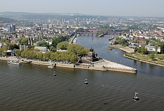
Koblenz, spelled Coblenz before 1926, is a German city situated on both banks of the Rhine where it is joined by the Moselle.

Rhin-et-Moselle was a department of the First French Republic and First French Empire in present-day Germany. It was named after the rivers Rhine and Moselle. It was formed in 1798, when the left bank of the Rhine was annexed by France. Until the French occupation, its territory was divided between the Archbishopric of Cologne, the Archbishopric of Trier, and the Electorate of the Palatinate. Its territory is now part of the German states of Rhineland-Palatinate and North Rhine-Westphalia. Its capital was Koblenz.

The Rhine Gorge is a popular name for the Upper Middle Rhine Valley, a 65 km section of the Rhine between Koblenz and Bingen in the states of Rhineland-Palatinate and Hesse in Germany. It was added to the UNESCO list of World Heritage Sites in June 2002 for a unique combination of geological, historical, cultural and industrial reasons.

Between Bingen and Bonn, Germany, the river Rhine flows as the Middle Rhine through the Rhine Gorge, a formation created by erosion, which happened at about the same rate as an uplift in the region, leaving the river at about its original level, and the surrounding lands raised. This gorge is quite deep, about 130 metres (430 ft) from the top of the rocks down to the average water-line.

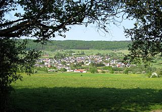
Treis-Karden is an Ortsgemeinde – a municipality belonging to a Verbandsgemeinde, a kind of collective municipality – in the Cochem-Zell district in Rhineland-Palatinate, Germany. It was the seat of the former like-named Verbandsgemeinde until 1 July 2014. Since then, it is part of the Verbandsgemeinde Cochem. Treis-Karden is a state-recognized tourism resort (Fremdenverkehrsort).

Burg (Mosel) is an Ortsgemeinde – a municipality belonging to a Verbandsgemeinde, a kind of collective municipality – in the Bernkastel-Wittlich district in Rhineland-Palatinate, Germany. It is purely a winegrowing and tourism centre.

Laubach is an Ortsgemeinde in the Cochem-Zell district in Rhineland-Palatinate, Germany. It belongs to the Verbandsgemeinde of Kaisersesch, whose seat is Kaisersesch. Laubach is a state-recognized tourist area.

Ellenz-Poltersdorf is an Ortsgemeinde – a municipality belonging to a Verbandsgemeinde, a kind of collective municipality – in the Cochem-Zell district in Rhineland-Palatinate, Germany. The winegrowing centre belongs to the Verbandsgemeinde of Cochem, whose seat is in the like-named town.

Illerich is an Ortsgemeinde – a municipality belonging to a Verbandsgemeinde, a kind of collective municipality – in the Cochem-Zell district in Rhineland-Palatinate, Germany. It belongs to the Verbandsgemeinde of Kaisersesch, whose seat is in the like-named town.

Tellig is an Ortsgemeinde – a municipality belonging to a Verbandsgemeinde, a kind of collective municipality – in the Cochem-Zell district in Rhineland-Palatinate, Germany. It belongs to the Verbandsgemeinde of Zell, whose seat is in the municipality of Zell an der Mosel.

Valwig is an Ortsgemeinde – a municipality belonging to a Verbandsgemeinde, a kind of collective municipality – in the Cochem-Zell district in Rhineland-Palatinate, Germany. It belongs to the Verbandsgemeinde of Cochem, whose seat is in the like-named town. Valwig is also a winegrowing centre.

Wirfus is an Ortsgemeinde – a municipality belonging to a Verbandsgemeinde, a kind of collective municipality – in the Cochem-Zell district in Rhineland-Palatinate, Germany. It belongs to the Verbandsgemeinde of Cochem, whose seat is in the like-named town.

The Basilica of St. Castor is the oldest church in Koblenz in the German state of Rhineland Palatinate. It is located near Deutsches Eck at the confluence of the Rhine and the Moselle. A fountain called Kastorbrunnen was built in front of the basilica during Napoleon’s invasion of Russia in 1812. Pope John Paul II raised St. Castor to a basilica minor on 30 July 1991. This church is worth seeing for the historical events that have occurred in it, its extensive Romanesque construction and its largely traditional furnishings.
Brigadier-General Charles Auguste Creutzer (1780–1832) was a French officer in Napoleon's Army.

The Left Bank of the Rhine was the region north of Lauterbourg, in present-day western Germany, that was conquered during the War of the First Coalition and annexed by France. Because the attempt to create a Cisrhenian Republic foundered, the territories west of the Rhine were reorganized into several départements among the French first republic. After the allied victory over Napoleon in 1814 these territories were provisionally administered by the Central Administrative Departement (Zentralverwaltungsdepartement). The Sarre province and the district of Landau in der Pfalz previously French before the Napoleonic Wars were under the definitive act of the congress of Vienna ceded to the members of the coalition. The recent annexations done under the first republic were restituted. From these territories the Bavarian Circle of the Rhine (Rheinkreis) and the Hessian province of Rhenish Hesse (Rheinhessen) were formed in 1816. The regions to the north went to Prussia and were initially part of the two provinces of Jülich-Cleves-Berg and the Grand Duchy of the Lower Rhine, from which the Rhine Province emerged in 1822. The southern left Rhine territories, which had for centuries been under imperial rule in the Holy Roman Empire had been seized by France, mostly in the 17th century, were annexed to the new German empire in 1871, following France's defeat in the Franco-Prussian War. The region was consolidated as the Imperial territory of Alsace-Lorraine for a period of 48 years (1871-1919), before being restituted to France in the wake of the First World War.
