Related Research Articles
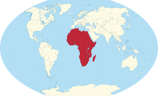
Africa is a continent comprising 63 political territories, representing the largest of the great southward projections from the main mass of Earth's surface. Within its regular outline, it comprises an area of 30,368,609 km2 (11,725,385 sq mi), excluding adjacent islands. Its highest mountain is Kilimanjaro; its largest lake is Lake Victoria.

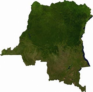
The Democratic Republic of the Congo (DRC) is the largest country of sub-Saharan Africa, occupying some 2,344,858 square kilometres (905,355 sq mi). Most of the country lies within the vast hollow of the Congo River basin. The vast, low-lying central area is a plateau-shaped basin sloping toward the west, covered by tropical rainforest and criss-crossed by rivers. The forest center is surrounded by mountainous terraces in the west, plateaus merging into savannas in the south and southwest. Dense grasslands extend beyond the Congo River in the north. High mountains of the Ruwenzori Range are found on the eastern borders with Rwanda and Uganda.

Katanga was one of the four large provinces created in the Belgian Congo in 1914. It was one of the eleven provinces of the Democratic Republic of the Congo between 1966 and 2015, when it was split into the Tanganyika, Haut-Lomami, Lualaba, and Haut-Katanga provinces. Between 1971 and 1997, its official name was Shaba Province.

Tanzania comprises many lakes, national parks, and Africa's highest point, Mount Kilimanjaro. Northeast Tanzania is mountainous, while the central area is part of a large plateau covered in grasslands. The country also contains the southern portion of Lake Victoria on its northern border with Uganda and Kenya.
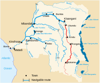
The Lualaba River flows entirely within the eastern part of Democratic Republic of the Congo. It provides the greatest streamflow to the Congo River, while the source of the Congo is recognized as the Chambeshi. The Lualaba is 1,800 kilometres (1,100 mi) long. Its headwaters are in the country's far southeastern corner near Musofi and Lubumbashi in Katanga Province, next to the Zambian Copperbelt.

The Luvua River is a river in the Katanga Province of the Democratic Republic of the Congo (DRC). It flows from the northern end of Lake Mweru on the Zambia-Congo border in a northwesterly direction for 350 kilometres (220 mi) to its confluence with the Lualaba River opposite the town of Ankoro. The Lualaba becomes the Congo River below the Boyoma Falls.
The Lufira River is a tributary of the Lualaba River in the Democratic Republic of the Congo (DRC).

The Lukuga River is a tributary of the Lualaba River in the Democratic Republic of the Congo (DRC) that drains Lake Tanganyika. It is unusual in that its flow varies not just seasonally but also due to longer term climate fluctuations.
Upemba National Park is a large national park in Haut-Lomami, Lualaba Province & Haut-Katanga Province of the southeastern Democratic Republic of Congo, formerly Zaire.

The Copperbelt is a natural region in Central Africa which sits on the border region between northern Zambia and the southern Democratic Republic of Congo. It is known for copper mining.
Katanga may refer to:

The Albertine Rift is the western branch of the East African Rift, covering parts of Uganda, the Democratic Republic of the Congo (DRC), Rwanda, Burundi and Tanzania. It extends from the northern end of Lake Albert to the southern end of Lake Tanganyika. The geographical term includes the valley and the surrounding mountains.
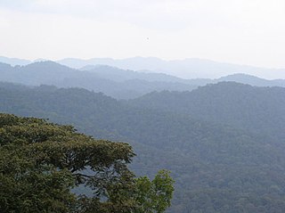
The Albertine Rift montane forests is a tropical moist broadleaf forest ecoregion in east-central Africa. The ecoregion covers the mountains of the northern Albertine Rift, and is home to distinct Afromontane forests with high biodiversity.
Articles related to the Democratic Republic of the Congo include:
Lake Tshangalele, also known as Lake Lufira or Mwadingusha Reservoir, is an artificial lake in the south-east of the Democratic Republic of Congo. It is located about 20 km east of the city of Likasi in the old province of Katanga. It lies at about 1,100 m above sea-level in a large depression surrounded by low mountains. It was created by a dam built on the Lufira River near Mwadingusha in 1926 to provide hydro-electric power. The area of open water is about 362.5 km2. During the wettest months of February and March, the area flooded reaches a maximum of 440 km2. The lake is shallow with a mean depth of only 2.6 m.
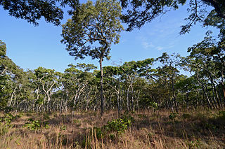
The Central Zambezian miombo woodlands ecoregion spans southern central Africa. Miombo woodland is the predominant plant community. It is one of the largest ecoregions on the continent, and home to a great variety of wildlife, including many large mammals.

Pweto is a town in the Haut-Katanga Province of the Democratic Republic of the Congo (DRC). It is the administrative center of Pweto Territory. The town was the scene of a decisive battle in December 2000 during the Second Congo War which resulted in both sides making more active efforts to achieve peace. Pweto and the surrounding region were devastated during the war. As of 2011 little had been done to restore infrastructure or rebuild the economy. The town is served by Pweto Airport.
The Kibara Mountains are a range in the Katanga Province of the Democratic Republic of the Congo. They are partly within the Upemba National Park.

The Congo–Nile Divide or the Nile–Congo Watershed is the continental divide that separates the drainage basins of the Congo and Nile rivers. It is about 2,000 kilometres (1,200 mi) long.
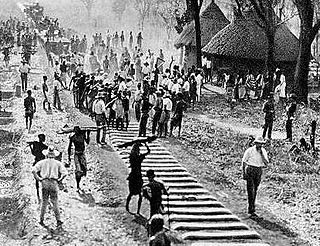
The Compagnie de Chemin de fer du Katanga (CFK) was a railway company in the Congo Free State and Belgian Congo between 1902 and 1952. It held the railway concession that linked the port of Bukama on the navigable section of the Lualaba River through the mining region and the town of Elisabethville (Lubumbashi) to Sakania, where it connected with the Rhodesian railway network. Operations were subcontracted to the Compagnie du chemin de fer du bas-Congo au Katanga (BCK).