
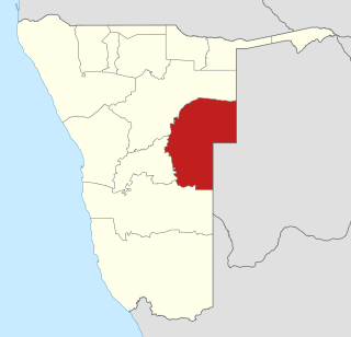
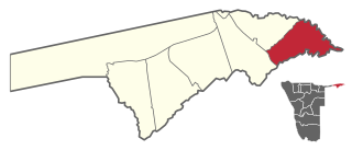
The Zambezi Region is one of Namibia's fourteen regions, situated in the north-eastern part of the country along the Zambezi River where it gets its name from. The region's capital is the town of Katima Mulilo. The Katima Mulilo Airport is 18 kilometres south-west of the town, while the village of Bukalo is located 43 kilometres south-east of Katima Mulilo. Formerly known as the Caprivi Region until 2013, it has eight electoral constituencies and a population of 142,373 according to the 2023 census.
Omaheke is one of the fourteen regions of Namibia, the least populous region. Its capital is Gobabis. It lies in eastern Namibia on the border with Botswana and is the western extension of the Kalahari desert. The self-governed villages of Otjinene, Leonardville and Witvlei are situated in the region. As of 2020, Omaheke had 48,594 registered voters.

Linyanti Constituency is located in Namibia's Zambezi Region. The constituency derives its name from the Linyanti River. It has a population of 10,425 and covers an area of 1,804 square kilometres, resulting in a population density of approximately 5.78 people per square kilometre.

Sibbinda Constituency is a constituency in Namibia's Zambezi Region, with its administrative centre located in the settlement of Sibbinda. As of 2023, it has a population of 17,126 residents.
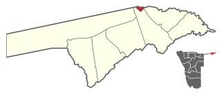
Katima Mulilo Urban is a constituency in Namibia's Zambezi Region. Its administrative centre is the region's capital, Katima Mulilo. The Katima Mulilo Airport is located 18 kilometres south-west of the town. The constituency has a population of 46,401 people, covers an area of 44.94 km², and has a population density of 1,033/km².

Windhoek Rural is a constituency in the Khomas Region of Namibia. Its district capital is the settlement of Groot Aub. It had a population of 22,254 in 2011, up from 20,212 in 2001. As of 2020, it has 13,625 registered voters.

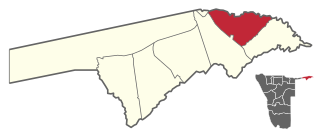
Katima Mulilo or simply Katima is the capital of the Zambezi Region in Namibia. It had 46,401 inhabitants in 2023, and comprises two electoral constituencies, Katima Mulilo Rural and Katima Mulilo Urban. It is located on the B8 national road on the banks of the Zambezi River in the Caprivi Strip in lush riverine vegetation with tropical birds and monkeys. The town receives annual average rainfall of 654 millimetres (25.7 in).

Rehoboth Rural is an electoral constituency in the Hardap region of Namibia. It had a population of 7,288 in 2011, down from 7,524 in 2001. The constituency office is in Schlip. Other settlements in Rehoboth Rural are Klein Aub, Khauxas and Rietoog. As of 2020, the constituency had 4,701 registered voters.

Kalahari Constituency is an electoral constituency in the Omaheke Region of eastern central Namibia. It had 9,234 inhabitants in 2004 and 5,294 registered voters in 2020. The constituency covers the rural area east of Gobabis as well as Gobabis' Nossobville suburb. The constituency office has been inaugurated in 2009 and is located at the Ben-Hur settlement. Kalahari constituency forms part of the border between Namibia and Botswana.
Mukwe is a constituency in the Kavango East region of Namibia. The district centre is the settlement of Mukwe. It had a population of 27,690 in 2011, up from 27,250 in 2001. The constituency contains the major settlements of Bagani, Kangongo and Divundu, and a number of small populated places such as Andara and Diyogha. As of 2020 the constituency had 16,678 registered voters.

Okahandja Constituency is an electoral constituency in the Otjozondjupa Region of Namibia. It had 18,155 inhabitants in 2004 and 18,109 registered voters in 2020. The constituency consists of the town of Okahandja and the surrounding rural area.

Okakarara Constituency is an electoral constituency in the Otjozondjupa Region of Namibia. It had 21,336 inhabitants in 2004 and 16,221 registered voters in 2020. The constituency consists of the town of Okakarara and the surrounding rural area.

Otjiwarongo Constituency is an electoral constituency in the Otjozondjupa Region of Namibia. It had 22,614 inhabitants in 2004 and 22,931 registered voters in 2020. The constituency consists of the town of Otjiwarongo and the surrounding rural area.

Aranos is a town in the Hardap Region of central Namibia, situated in the Nossob River basin in the Kalahari Desert.
Walvis Bay Rural constituency is a constituency in the Erongo Region of Namibia. It comprises the rural area surrounding the constituency's district capital city of Walvis Bay, and additionally some streets on the outskirts of the city. It had a population of 26,916 in 2011, up from 16,293 in 2001. As of 2020 the constituency had 25,746 registered voters.

Walvis Bay Urban is a constituency in the Erongo Region of Namibia, comprising most of the city of Walvis Bay. It had a population of 35,828 in 2011, up from 27,941 in 2001. As of 2020 the constituency had 25,311 registered voters.

Opuwo Rural is an electoral constituency in the Kunene Region of Namibia. The administrative centre of Opuwo Rural is the settlement of Otuani. As of 2020, it has 7,315 registered voters.
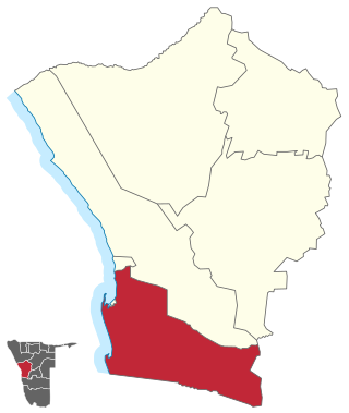
Kabbe South is a constituency in Namibia's Zambezi Region. The administrative centre of the constituency is the settlement of Nakabolelwa, situated 79 kilometres south-east of the region's capital, Katima Mulilo. It has a population of 142,373 and covers an area of 1,258 km², resulting in a population density of approximately 9.021/km².

Opuwo Urban is a constituency in the Kunene Region of Namibia. It comprises the townlands of Opuwo, which is also its administrative centre. As of 2020, it has 10,590 registered voters.
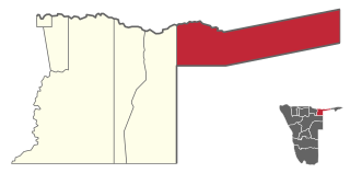
Kabbe North is a constituency in Namibia's Zambezi Region. The administrative centre of the constituency is the settlement of Kabbe, situated 53 kilometres south-east of the region's capital, Katima Mulilo. It has a population of 12,253 and covers an area of 1,183 km², resulting in a population density of approximately 10.36/km².
