Katraj, Solapur district

Last updated

Katraj
village
CountryFlag of India.svg  India
State Maharashtra
District Solapur district
Languages
  Official Marathi
Time zone IST (UTC+5:30)

Katraj is a village in the Karmala taluka of Solapur district in Maharashtra state, India.
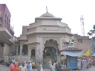
The Movie Town

Solapur district District of Maharashtra in India

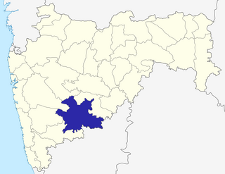
Solapur District is a district in Maharashtra state of India. The city of Solapur is the district headquarters. It is located on the south east edge of the state and lies entirely in the Bhima and Seena basins. The entire district is drained by the Bhima River.

Maharashtra State in western India

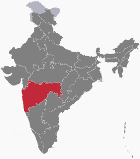
Maharashtra is a state in the western peninsular region of India occupying a substantial portion of the Deccan plateau. It is the second-most populous state and third-largest state by area in India. Spread over 307,713 km2 (118,809 sq mi), it is bordered by the Arabian Sea to the west, the Indian states of Karnataka and Goa to the south, Telangana and Chhattisgarh to the east, Gujarat and Dadra and Nagar Haveli to the north west, and Madhya Pradesh to the north. It is also the world's second-most populous subnational entity. It was formed by merging the western and south-western parts of the Bombay State, Berar and Vidarbha, and the north-western parts of the Hyderabad State and splitting Saurashtra by the States Reorganisation Act. It has over 112 million inhabitants and its capital, Mumbai, has a population around 18 million making it the most populous urban area in India. Nagpur hosts the winter session of the state legislature. Pune is known as 'Oxford of the East' due to the presence of several well-known educational institutions.

Demographics

Covering 838 hectares (2,070 acres) and comprising 273 households at the time of the 2011 census of India, Katraj had a population of 1354. There were 677 males and 677 females, with 162 people being aged six or younger. [1]

The 15th Indian Census was conducted in two phases, house listing and population enumeration. House listing phase began on 1 April 2010 and involved collection of information about all buildings. Information for National Population Register was also collected in the first phase, which will be used to issue a 12-digit unique identification number to all registered Indian residents by Unique Identification Authority of India (UIDAI). The second population enumeration phase was conducted between 9 and 28 February 2011. Census has been conducted in India since 1872 and 2011 marks the first time biometric information was collected. According to the provisional reports released on 31 March 2011, the Indian population increased to 1.21 billion with a decadal growth of 17.70%. Adult literacy rate increased to 74.04% with a decadal growth of 9.21%. The motto of the census was 'Our Census, Our future'.

Related Research Articles

Takali is a village in the Karmala taluka of Solapur district in Maharashtra state, India.

Osmanabad district is an administrative district in the Marathwada region in the Indian state of Maharashtra.The district headquarter is located at Osmanabad. This primarily rural district occupies an area of 7569 km² of which 241.4 km² is urban and has a population of 1,660,311 of which 16.96% were urban.

Pandharpur Town in Maharashtra, India

Pandharpur is a well known pilgrimage town on the banks of Chandrabhaga River in Solāpur district, Maharashtra, India. Pandharpur is situated on 17°11' north latitude and 75°11' east longitude in Solapur District. The Vithoba temple attracts about a million Hindu pilgrims during the major yātrā (pilgrimage) in Ashadh (June–July). A small temple of Shri. Vitthal-Rukmini is also located, which is as old as the main Vitthal-Rukmini Mandir, in Isbavi area of Pandharpur known as Wakhari Va Korti Devalayas and also known as Visava mandir.

Solapur railway station

Solapur railway station is located in Solapur district in the Indian state of Maharashtra and serves Solapur city and the industrial belt around it. It is headquarters of Solapur Railway Division and a part of Central Railway zone.It is the 4th cleanest railway station in India ranked A-1 among 500 main stations in India

Hingani is a village in the Karmala taluka of Solapur district in Maharashtra state, India.

Khatgaon is a village in the Karmala taluka of Solapur district in Maharashtra state, India.

Maroli is a village in the Mangalvedha taluka of Solapur district in Maharashtra state, India.

Washibe is a village in the Karmala taluka of Solapur district in Maharashtra state, India.

Vanjanwadi is a village in the Karmala taluka of Solapur district in Maharashtra state, India.

Vihal is a village in the Karmala taluka of Solapur district in Maharashtra state, India.

Rajuri is a village in the Karmala taluka of Solapur district in Maharashtra state, India.

Manjargaon is a village in the Karmala taluka of Solapur district in Maharashtra state, India.

Aljapur is a village in the Karmala taluka of Solapur district in Maharashtra state, India.

Borgaon is a village in the Karmala taluka of Solapur district in Maharashtra state, India.

Dilmeshwar is a village in the Karmala taluka of Solapur district in Maharashtra state, India.

Hilvare is a village in the Karmala taluka of Solapur district in Maharashtra state, India.

Salse is a village in the Karmala taluka of Solapur district in Maharashtra state, India.

References

  1. "Census of India 2011: Maharashtra Series 28, Part XII District Census Handbook Solapur Primary Census Abstract" (PDF). Directorate of Census Operations Maharashtra. p. 108. Retrieved 2018-01-24.