Katrenikona | |
|---|---|
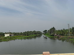 Godavari canal near Katrenikona | |
 Interactive map of Katrenikona | |
 Katrenikona Location in Andhra Pradesh, India  Katrenikona Katrenikona (India) | |
| Coordinates: 16°34′55″N82°09′14″E / 16.5818377°N 82.153793°E | |
| Country | |
| State | Andhra Pradesh |
| District | Dr. B.R. Ambedkar Konaseema |
| Area | |
• Total | 28.47 km2 (10.99 sq mi) |
| Population (2011) [1] | |
• Total | 13,678 |
| • Density | 480.4/km2 (1,244/sq mi) |
| Languages | |
| • Official | Telugu |
| Time zone | UTC+5:30 (IST) |
| PIN | 533212 |
| Telephone code | 91- |
| Vehicle Registration | AP05 (Former) AP39 (from 30 January 2019) [2] |
Katrenikona is a village in Dr. B.R. Ambedkar Konaseema district of the Indian state of Andhra Pradesh. It is located in Katrenikona Mandal of Amalapuram revenue division of the district. [1] [3]