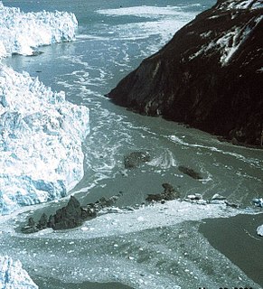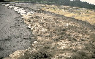
A lahar is a violent type of mudflow or debris flow composed of a slurry of pyroclastic material, rocky debris and water. The material flows down from a volcano, typically along a river valley.

Glacier Peak or Dakobed is the most isolated of the five major stratovolcanoes of the Cascade Volcanic Arc in the U.S state of Washington. Located in the Glacier Peak Wilderness, the volcano is visible from the west in Seattle, and from the north in the higher areas of eastern suburbs of Vancouver such as Coquitlam, New Westminster and Port Coquitlam. The volcano is the fourth tallest peak in Washington state, and not as much is known about it compared to other volcanoes in the area. Local Native Americans have recognized Glacier Peak and other Washington volcanoes in their histories and stories. When American explorers reached the region, they learned basic information about surrounding landforms, but did not initially understand that Glacier Peak was a volcano. Positioned in Snohomish County, the volcano is only 70 miles (110 km) northeast of Seattle. The other volcano closer to Seattle is Mount Rainier, but as Glacier Peak is set farther into the Cascades and almost 4,000 feet (1,200 m) shorter, it is less noticeable than Mount Rainier.
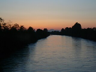
The Puyallup River is a river in the U.S. state of Washington. About 45 miles (72 km) long, it is formed by glaciers on the west side of Mount Rainier. It flows generally northwest, emptying into Commencement Bay, part of Puget Sound. The river and its tributaries drain an area of about 948 square miles (2,460 km2) in Pierce County and southern King County.

The Nisqually Glacier is one of the larger glaciers on the southwestern face of Mount Rainier in the U.S. state of Washington. The glacier is one of the most easily viewed on the mountain, and is accessible from the Paradise visitor facilities in Mount Rainier National Park. The glacier has had periods of advance and retreat since 1850 when it was much more extensive. It is currently retreating. Measurements made at 9,200 feet (2,800 m) altitude show that glacier got 56 ft (17 m) thicker between 1994 and 1997, suggesting that it will probably begin advancing in the first decade of the 21st century. Nisqually Glacier is the source of the Nisqually River.
The Van Trump Glacier is actually a scattering of glaciers and snowfields located on the southern flank of Mount Rainier in Washington. Named after P. B. Van Trump, who was part of an early ascent of Mount Rainier, the glacier covers 0.2 square miles (0.5 km2) and contains 500 million ft3 of ice. The glacier is located between the Wilson Glacier to the east and the Kautz Glacier to the west. The elevation of the scattering ranges from 7,000 feet (2,100 m) at the lower end to 9,800 ft (3,000 m) on the upper reaches of the glacier. Meltwater from the glacier drains into the Nisqually River.
The Success Glacier is a small glacier located on the southwestern slopes of Mount Rainier in Washington. It covers 0.3 square miles (0.8 km2) and contains 500 million cubic ft of ice. The glacier is bounded to the northwest by the Success Cleaver and to the east by the Kautz Cleaver. Starting from a steep rocky slope at about 11,000 feet (3,400 m), the glacier flows southward downhill. At around 9,000 feet (2,700 m), a small snowfield joins this glacier with the Pyramid Glacier to the southwest. Soon after this point, the glacier joins the adjacent Kautz Glacier at 8,600 feet (2,600 m). The joined glaciers flow until their terminus at about 6,000 ft (1,800 m). Meltwater from the glacier drains into the Nisqually River.
The Winthrop Glacier is a large glacier on the northeastern side of Mount Rainier in Washington. Named after Theodore Winthrop, the body of ice covers 3.5 mile2 (9.1 km2) and has a volume of 18.5 billion feet3. Starting at over 14,300 feet (4,400 m) at the Columbia Crest, the glacier heads north and descends steeply over the uneven topography of Rainier. Another glacier, the Emmons Glacier is directly connected to this glacier up to the Steamboat Prow. After passing the Prow, the glaciers split up; the Emmons heads east-northeastward and the Winthrop continues northeast. As the terrain becomes flatter, the Winthrop glacier becomes heavily rock-covered when it terminates in a forest at about 4,900 ft (1,500 m). Meltwater from the glacier drains into the White River.
The South Tahoma Glacier is a glacier located on the southwest flank of Mount Rainier in State of Washington. It covers 1.1 square miles (2.8 km2) and contains 4.6 billion ft3 of ice. Starting from an elevation of around 10,600 feet (3,200 m) at the base of a steep cliff, the glacier flows down southwest with the larger, adjacent Tahoma Glacier lying to the north. The smaller South Tahoma is connected to the Tahoma at an ice patch located in midway down the South Tahoma. From then on, the glacier narrows and flows down southwest and accumulates rock debris before turning and ending at an elevation of around 5,100 feet (1,600 m). The southern ice stream used to be connected to a northern ice stream coming down south from the Tahoma Glacier encompassing a jagged 7,690 feet (2,344 m) high sub-peak of Rainier called Glacier Island, but retreat has separated the glaciers at an elevation below 8,000 ft (2,400 m). Meltwater from the glacier drains into the Nisqually River.
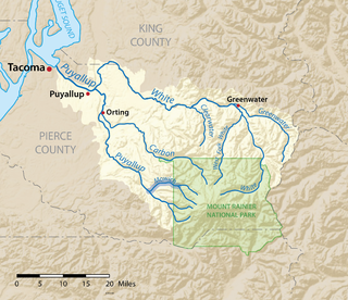
The Mowich River is a river in the U.S. state of Washington. Its watershed drains a portion of the western side of Mount Rainier, part of the Cascade Range. The river has two main headwater branches, the South Mowich River and the North Mowich River. The South Mowich is significantly larger and sometimes considered the main river. The Mowich and its tributaries drain several of Mount Rainier's glaciers. The upper portion of its watershed is contained within Mount Rainier National Park. The river flows into the Puyallup River in the foothills west of Mount Rainier.

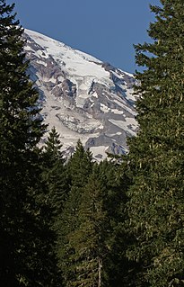
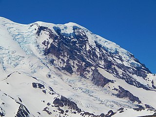
Mount Rainier, also known as Tahoma or Tacoma, is a large active stratovolcano located 59 miles (95 km) south-southeast of Seattle, in the Mount Rainier National Park. With a summit elevation of 14,411 ft (4,392 m), it is the highest mountain in the U.S. state of Washington, and of the Cascade Range of the Pacific Northwest, it is the second topographically prominent mountain in the continental United States and the first in the Cascade Volcanic Arc.
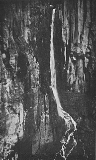
Van Trump Creek, also called Van Trump Falls Creek or the Van Trump Fork of the Nisqually River, is a creek in Pierce County, Washington. It is a tributary of the Nisqually River, joining the river just above the mouth of the Paradise River. The creek is known for having several well known waterfalls along its course.
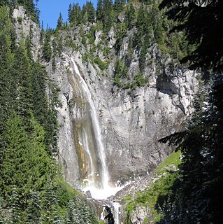
Comet Falls is a tall waterfall located on Van Trump Creek in Pierce County, Washington. The falls are thought to be the best in the Mount Rainier region.

The Paradise River is a small, short but swift river in Pierce County, Washington. It is the first major tributary of the Nisqually River. Located entirely within the bounds of Mount Rainier National Park, it is notable for its waterfalls, of which there are eight.
Kautz Creek Falls is a waterfall on Kautz Creek in the Mount Rainier National Park in the state of Washington. It was formed when the Kautz Glacier retreated in the last 50 years, creating a series of long and slender cascades totaling about 400 feet (120 m) in height down a tall glacial cliff, with a highest drop of 150 feet (46 m). The falls consist of two parts, each with two distinct tiers. One of these parts flows from the upper lobe of the Kautz Glacier and disappears under the lower lobe. The water flowing over this stage is generally clear. As the water passes underneath the lower lobe, however; it has a muddy appearance caused by glacial moraine, which explains the muddy appearance of Kautz Creek.
Pearl Falls is one of the highest waterfalls in Mount Rainier National Park in the U.S. state of Washington. It is fed by the glacial Pearl Creek, occurring about halfway along the creek's course.

The Muddy River is a stream, about 29 miles (47 km) long, southeast of Mount St. Helens in the U.S. state of Washington. The Muddy River flows south–southeast and joins the Lewis River just above the Swift Reservoir. The Lewis River flows west and is a tributary to the Columbia River. The east flank of Mount St. Helens is within the watershed of Muddy Creek.
The Bridge for Kids is a proposed bridge across the Carbon River in Orting, Washington, about a mile upstream of where it joins the Puyallup River. It would provide an emergency evacuation route for school children to escape a future lahar flow from Mount Rainier, consisting of an up to 10-meter (33 ft) high flood of mud, rock and boulders. As of 2016, the $40 million bridge was still in the planning phase.