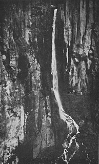
Multnomah Falls is a waterfall located in the Columbia River Gorge, east of Troutdale, between Corbett and Dodson, Oregon, United States. The waterfall is accessible from the Historic Columbia River Highway and Interstate 84. Spanning two tiers on basalt cliffs, it is the tallest waterfall in the state of Oregon at 620 ft (189 m) in height.

The Grand Coulee is an ancient river bed in the U.S. state of Washington. This National Natural Landmark stretches for about 60 miles southwest from Grand Coulee Dam to Soap Lake, being bisected by Dry Falls into the Upper and Lower Grand Coulee.
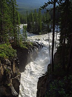
Sunwapta Falls is a pair of waterfalls of the Sunwapta River located in Jasper National Park, Alberta, Canada.
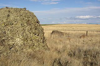
Sims Corner Eskers and Kames National Natural Landmark and nearby McNeil Canyon Haystack Rocks and Boulder Park natural landmarks contain excellent examples of Pleistocene glacial landforms. Sims Corner Eskers and Kames National Natural Landmark includes classic examples of ice stagnation landforms such as glacial erratics, terminal moraines, eskers, and kames. It is located on the Waterville Plateau of the Columbia Plateau in north central Washington state in the United States.
The River Warren Falls was a massive waterfall on the glacial River Warren initially located in present-day Saint Paul, Minnesota, United States. The waterfall was 2700 feet (823 m) across and 175 feet (53 m) high.
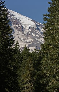
The Kautz Glacier is a narrow glacier on the southern flank of Mount Rainier in Washington. Named for August Kautz, who is sometimes credited for the first ascent of Mount Rainier, covers 1.8 square miles (4.7 km2) and contains 7.8 billion ft3 of ice. Upper Kautz Glacier extends south from the summit ice cap to Kautz Ice Cliff at about 11,700 feet (3,600 m). Immediately west of the main ice cliff, the glacier continues down Kautz Chute which terminates in another ice cliff just above the lower Kautz Glacier at 10,800 feet (3,300 m). Usually reached by a short descent from Camp Hazard at 11,300 feet (3,400 m) on Wapowety Cleaver, climbers following the Kautz Glacier climbing route ascend this chute to the upper glacier.

The Ohanapecosh Glacier is small glacier located on Mount Rainier's southeastern flanks in Washington. It covers 0.6 square miles (1.6 km2) and contains 1.3 billion ft3 of ice. The glacier consists of several lobes of ice interconnected by thin snowfields. Most of the glacier lies at an elevation of 8,300 feet (2,500 m) to 7,400 feet (2,300 m), near the Whitman and the Fryingpan Glacier. Since this ice lobe ends on a cliff, it contributes ice to the lower portions of the Ohanapecosh Glacier. The lower sections of this glacier end on cliffs and a small valley at about 6,100 ft (1,900 m) in elevation. Meltwater from the glacier drains into the Ohanapecosh River and the Muddy Fork Cowlitz River, which merge downstream about four miles (6 km) outside of Mount Rainier National Park into the Cowlitz River.

The Kankakee Outwash Plain is a flat plain interspersed with sand dunes in the Kankakee River valley in northwestern Indiana and northeastern Illinois of the United States. It is just south of the Valparaiso Moraine and was formed during the Wisconsin Glaciation. As the glacier, stopped at the Valparaiso Moraine, melted, the meltwater was carried away to the outwash plain. On the south side of the moraine, where the elevation drops, the meltwaters eroded away valleys, carrying sand and mud with them. As the muddy meltwater reached the valley where the slope lessened, the water slowed down, depositing the sand on the outwash plain. This created a smooth, flat, and sandy plain. Before its draining, the Kankakee Marsh, located on the outwash plain, was one of the largest freshwater marshes in the United States.
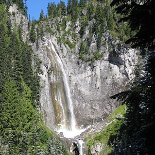
Blum Basin Falls is a waterfall in Whatcom County, in the U.S. state of Washington. It is located in North Cascades National Park on the headwaters of Blum Creek, a tributary of the Baker River. Fed by two small retreating glaciers and several snowfields on the southern side of Mount Blum, the waterfall is formed by the largest meltwater stream that feeds the mainstem of Blum Creek. The falls tumble 1,680 feet (510 m) down a high glacial headwall several miles within the national park in two distinct stages; the first is a series of slides over rounded rock, above the tree line, and the second is a series of near-vertical plunges to the forested valley below. Although most of the falls is clearly visible, parts of it are obscured by tall pines that grow at its base. There is no trail leading to the waterfall.
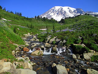
Van Trump Creek, also called Van Trump Falls Creek or the Van Trump Fork of the Nisqually River, is a creek in Pierce County, Washington. It is a tributary of the Nisqually River, joining the river just above the mouth of the Paradise River. The creek is known for having several well known waterfalls along its course.

Eagle Creek is a tributary of the Columbia River in Multnomah and Hood River counties in the U.S. state of Oregon. It cuts through a narrow canyon in its 3,200 feet (980 m) descent to the Columbia River Gorge and is known for its concentration of 13 waterfalls in about 5 miles (8.0 km) distance. Eight major falls are on Eagle Creek and the East Fork Eagle Creek itself, while five are on its tributaries.

Salt Creek Falls is a cascade and plunge waterfall on Salt Creek, a tributary of the Middle Fork Willamette River, that plunges into a gaping canyon near Willamette Pass in the Willamette National Forest, near Oakridge, Oregon. The waterfall is notable for its main drop of 286 feet (87 m) which makes it the third highest plunge waterfall in Oregon after Multnomah Falls and Watson Falls the second highest, which was re-measured in 2009 and found to be 293 feet rather than an earlier measurement of 272 feet passing Salt Creek Falls. The pool at the bottom of the waterfall is 20 metres (66 ft) deep.

Sulphide Creek is a 2.5-mile (4.0 km) glacial tributary of the Baker River in Whatcom County in the U.S. state of Washington, draining a steep and narrow canyon on the southeast flank of Mount Shuksan, inside North Cascades National Park. Although called a creek, it is river-like due to its high volume. The creek is fed by the "massive" Sulphide and Crystal glaciers above Sulphide Lake and it runs east collecting several small tributaries before flowing into the Baker River at elevation 869 feet (265 m). There are several very tall waterfalls occurring on the creek and its tributaries, the largest of which is Sulphide Creek Falls.

Lake Kankakee formed 14,000 years before present (YBP) in the valley of the Kankakee River. It developed from the outwash of the Michigan Lobe, Saginaw Lobe, and the Huron-Erie Lobe of the Wisconsin glaciation. These three ice sheets formed a basin across Northwestern Indiana. It was a time when the glaciers were receding, but had stopped for a thousand years in these locations. The lake drained about 13,000 YBP, until reaching the level of the Momence Ledge. The outcropping of limestone created an artificial base level, holding water throughout the upper basin, creating the Grand Kankakee Marsh.

Peričnik Falls is a waterfall in Triglav National Park, Slovenia.

Buttermilk Creek is a tributary of the Susquehanna River in Lackawanna County and Wyoming County, in Pennsylvania, in the United States. It is approximately 6.8 miles (10.9 km) long and flows through Newton Township in Lackawanna County and Falls Township in Wyoming County. The watershed of the creek has an area of 26.1 square miles (68 km2). The creek is a perennial stream and is not designated as an impaired waterbody. Major geographical features in its watershed include the Buttermilk Falls in its lower reaches, as well as Fords Lake and Lake Winola.

Lake Circle was a glacial lake that formed during the late Pleistocene epoch along the Redwater River in eastern Montana. After the Laurentide ice sheet retreated, glacial ice melt accumulated in the basin surrounded by the ridges of the preglacial valley and the retreating glacier. Southwest of Nickwall are the remnants of a broad abandoned valley with long side slopes. The valley runs north from Redwater Creek to the Missouri River. The bottom is poorly drained and about 1 mile (1.6 km) in width. It lies 2,015 to 2,020 feet above the sea level and 40 to 50 feet above the Missouri River bottomland. The upland slopes are extensive, clear and flat. The valleys surrounding it are dissected with V-shaped coulees. The difference between the Redwater valley and those around it reflect stream erosion vs. lake sedimentation. The drift in the valleys, appears to be as left by the glacier in the previously created valleys. Using the dating of lake deposits near Great Falls, Montana, the Havre lobe of the Laurentide ice sheet dammed the ancestral Missouri River during the late Wisconsin Glacial Period.
Lake Cut Bank was a glacial lake formed during the late Pleistocene along the Missouri and Sun Rivers. After the Laurentide ice sheet retreated, water melting off the glacier accumulated between the Rocky Mountinas and the ice sheet. The lake drained along the front of the ice sheet, eastward towards the Judith River and the Missouri River.