
The Snoqualmie River is a 45-mile (72 km) long river in King County and Snohomish County in the U.S. state of Washington. The river's three main tributaries are the North, Middle, and South Forks, which drain the west side of the Cascade Mountains near the town of North Bend and join near the town of Snoqualmie just above the Snoqualmie Falls. After the falls the river flows north through rich farmland and the towns of Fall City, Carnation, and Duvall before meeting the Skykomish River to form the Snohomish River near Monroe. The Snohomish River empties into Puget Sound at Everett. Other tributaries of the Snoqualmie River include the Taylor River and the Pratt River, both of which enter the Middle Fork, the Tolt River, which joins at Carnation, and the Raging River at Fall City.

Uvas Canyon County Park is a 1,147-acre (464 ha) natural park located in upper Uvas Canyon on the eastern side of the Santa Cruz Mountains, west of Morgan Hill, California. The park has several small waterfalls, some of which flow perennially, that feed into tributaries confluent with Uvas Creek. The park is part of the Santa Clara County Parks System, and facilitates picnics, hiking and overnight camping. It is one of the few parks in the area that allows dogs in the campgrounds.

Bonita Falls are a set of waterfalls in the San Bernardino National Forest, formed by Bonita Creek, that is said to be 370 or 400 feet in height, but possibly up to 495 feet high because of two undocumented drops in the canyon above. It is the second tallest in the national forest, being surpassed only by 500-foot (150 m) Big Falls. These two waterfalls are reputably the tallest in southern California.
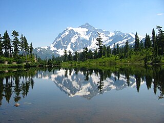
There are four prominent waterfalls in the basin of a short tributary of Sulphide Creek, on the southeast flank of 9,127-foot (2,781m) Mount Shuksan in North Cascades National Park, Washington. Seahpo Peak Falls and Cloudcap Falls, the taller two of the three, are located on separate streams that converge and plunge over Rockflow Canyon Falls. The unnamed outlet stream from these waterfalls flows into Sulphide Creek, which flows into the Baker River. Another waterfall is Jagged Ridge Falls, on a tributary of the unnamed stream.
Deer Falls is the uppermost waterfall on the North Fork Skykomish River. The falls occur within a short but impressive canyon just above the mouth of Goblin Creek.
Walupt Creek Falls is a relatively obscure, but massive waterfall on Walupt Creek, a large tributary of the Cispus River in Lewis County, Washington, at an elevation of 3,500 feet (1,100 m). The falls cascade 221 feet (67 m) down a bedrock cliff in two tiers, with an average breadth of 204 feet (62 m), a maximum breadth of 267 feet (81 m) and an average flow of over 150 cubic feet (4.2 m3) per second. The creek begins the drop by falling down a 10 feet (3.0 m) cascade, then impacts a large, bell-shaped dome and spreads into a wide fan, dropping 200 feet (61 m). The final drop is a gently sloping slide that flows directly into the Cispus River. The feeder river, Walupt Creek, is sourced directly from Walupt Lake which provides a consistent flow throughout the year. The drainage basin of the river is also fairly large.

Van Trump Creek, also called Van Trump Falls Creek or the Van Trump Fork of the Nisqually River, is a creek in Pierce County, Washington. It is a tributary of the Nisqually River, joining the river just above the mouth of the Paradise River. The creek is known for having several well known waterfalls along its course.
Upper Comet Falls is a waterfall in Pierce County, Washington. It is located along Van Trump Creek and is located a ways above Comet Falls. The falls may have been formed as a result of the floods of 2003 and 2006 that came down Van Trump Creek.

Comet Falls is a tall waterfall located on Van Trump Creek in Pierce County, Washington. The falls are thought to be the best in the Mount Rainier region.

Christine Falls is a waterfall on Van Trump Creek in Pierce County, Washington. The falls are 69 feet (21 m) feet high and are best known for the Christine Falls Bridge spanning the lower drop. The upper drop is 32 feet (9.8 m) high and is almost impossible to film in tandem with the oft-photographed 37-foot (11 m) lower tier. The lower tier is probably one of the most commonly photographed locations in the Mount Rainier area.
Asbestos Falls is a waterfall on Clear Creek in Snohomish County, Washington. It is located just above the mouth of Helena Creek.
Big Heart Falls is a waterfall on the outlet stream of Big Heart Lake, which eventually flows into the Skykomish River, in King County, Washington. It is located between the outlet of Big Heart Lake and the inlet of Delta Lake. The falls are said to drop approximately 1,268 feet (386 m).

Kautz Creek is a tributary of the Nisqually River, flowing from the Kautz Glacier, with its watershed in the Mount Rainier National Park of Washington. It drains southwest from Mount Rainier for about 6 miles (9.7 km) before it joins the Nisqually River near Mount Rainier Highway. It is notable for being a severe flooding hazard due to the volume of summer glacier melt and its frequently changing course. The 400-foot (120 m) Kautz Creek Falls on the headwaters of the creek was formed by the retreat of the Kautz Glacier in the past 50 years.

Eagle Creek is a tributary of the Columbia River in Multnomah and Hood River counties in the U.S. state of Oregon. It cuts through a narrow canyon in its 3,200 feet (980 m) descent to the Columbia River Gorge and is known for its concentration of 13 waterfalls in about 5 miles (8.0 km) distance. Eight major falls are on Eagle Creek and the East Fork Eagle Creek itself, while five are on its tributaries.
There are multiple waterfalls in the basin of the North Fork Cascade River, a river in the North Cascades of Washington that drains to the Cascade River. Many of these are taller than the more famous waterfalls in North America, but do not receive much attention due to their remoteness.

Narada Falls is a waterfall in Mount Rainier National Park, in the U.S. state of Washington. It is said to be the most popular, because the Mount Rainier Highway crosses the falls between its two tiers.
Sydney Falls, more commonly called Kotsuck Creek Falls or Kotsuck Falls, is a waterfall in the Mount Rainier National Park in the U.S. state of Washington.
The Paradise River in Washington state, United States, is known for having a total of eight major waterfalls.
Ashlu Falls is a short but significant waterfall along lower Ashlu Creek. The falls are located about 6 km above the mouth of Ashlu Creek and mark the head of Ashlu Canyon. The creek is actually crossed by a logging road bridge between the two tiers.

Havasu Creek is a stream in the U.S. state of Arizona associated with the Havasupai people. It is a tributary to the Colorado River, which it enters in the Grand Canyon.

