
Yosemite Falls is the highest waterfall in Yosemite National Park, dropping a total of 2,425 feet (739 m) from the top of the upper fall to the base of the lower fall. Located in the Sierra Nevada of California, it is a major attraction in the park, especially in late spring when the water flow is at its peak.

Multnomah Falls is a waterfall located on Multnomah Creek in the Columbia River Gorge, east of Troutdale, between Corbett and Dodson, Oregon, United States. The waterfall is accessible from the Historic Columbia River Highway and Interstate 84. Spanning two tiers on basalt cliffs, it is the tallest waterfall in the state of Oregon at 620 ft (189 m) in height. The Multnomah Creek Bridge, built in 1914, crosses below the falls, and is listed on the National Register of Historic Places.

The Bridal Veil Falls is a waterfall located on Bridal Veil Creek along the Columbia River Gorge in Multnomah County, Oregon, United States. The waterfall is accessible from the historic Columbia River Highway and Interstate 84. Spanning two tiers on basalt cliffs, it is the only waterfall which occurs below the historic Columbia Gorge Scenic Highway. The Bridal Veil Falls Bridge, built in 1914, crosses over the falls, and is listed on the National Register of Historic Places.

Whatcom Falls Park is a 241-acre (0.98 km2) park in Bellingham, Washington, United States. The falls are on Whatcom Creek, which leads from Lake Whatcom to Bellingham Bay. The park has four sets of waterfalls and several miles of well maintained walking trails.

Linville Falls is a waterfall located in the Blue Ridge Mountains of North Carolina in the United States. The falls move in several distinct steps, beginning in a twin set of upper falls, moving down a small gorge, and culminating in a high-volume 45-foot (14 m) drop.
Blum Basin Falls is a waterfall in Whatcom County, in the U.S. state of Washington. It is located in North Cascades National Park on the headwaters of Blum Creek, a tributary of the Baker River. Fed by two small retreating glaciers and several snowfields on the southern side of Mount Blum, the waterfall is formed by the largest meltwater stream that feeds the mainstem of Blum Creek. The falls tumble 1,680 feet (510 m) down a high glacial headwall several miles within the national park in two distinct stages; the first is a series of slides over rounded rock, above the tree line, and the second is a series of near-vertical plunges to the forested valley below. Although most of the falls is clearly visible, parts of it are obscured by tall pines that grow at its base. There is no trail leading to the waterfall.
Wy'east Falls is a waterfall on a small tributary of Eagle Creek in Hood River County, Oregon, U.S.
Walupt Creek Falls is a relatively obscure, but massive waterfall on Walupt Creek, a large tributary of the Cispus River in Lewis County, Washington, at an elevation of 3,500 feet (1,100 m). The falls cascade 221 feet (67 m) down a bedrock cliff in two tiers, with an average breadth of 204 feet (62 m), a maximum breadth of 267 feet (81 m) and an average flow of over 150 cubic feet (4.2 m3) per second. The creek begins the drop by falling down a 10 feet (3.0 m) cascade, then impacts a large, bell-shaped dome and spreads into a wide fan, dropping 200 feet (61 m). The final drop is a gently sloping slide that flows directly into the Cispus River. The feeder river, Walupt Creek, is sourced directly from Walupt Lake which provides a consistent flow throughout the year. The drainage basin of the river is also fairly large.

Sulphide Creek Falls is a tall, moderately large volume waterfall within North Cascades National Park in Washington state that is one of the tallest waterfalls in North America. The falls drop from Sulphide Lake on the southeast side of Mount Shuksan down a narrow flume-like canyon to a broad basin below. Because of the narrow, twisting shape of the canyon the waterfall is exceptionally difficult to see from ground-level perspectives. The total vertical drop of the waterfall is in the range of 2,100 feet (640 m) to 2,200 feet (670 m) feet, but it has not yet been accurately measured. Foot access to the bottom of the waterfall involves 2.5 miles (4.0 km) of off-trail travel in extremely brushy terrain and several potentially dangerous fords of a large stream.
Kautz Creek Falls is a waterfall on Kautz Creek in the Mount Rainier National Park in the state of Washington. It was formed when the Kautz Glacier retreated in the last 50 years, creating a series of long and slender cascades totaling about 400 feet (120 m) in height down a tall glacial cliff, with a highest drop of 150 feet (46 m). The falls consist of two parts, each with two distinct tiers. One of these parts flows from the upper lobe of the Kautz Glacier and disappears under the lower lobe. The water flowing over this stage is generally clear. As the water passes underneath the lower lobe, however; it has a muddy appearance caused by glacial moraine, which explains the muddy appearance of Kautz Creek.

Eagle Creek is a tributary of the Columbia River in Multnomah and Hood River counties in the U.S. state of Oregon. It cuts through a narrow canyon in its 3,200 feet (980 m) descent to the Columbia River Gorge and is known for its concentration of 13 waterfalls in about 5 miles (8.0 km) distance. Eight major falls are on Eagle Creek and the East Fork Eagle Creek itself, while five are on its tributaries.
Mazama Falls, also referred to more simply as Wells Creek Falls, is a waterfall on Wells Creek in the U.S. state of Washington. At nearly 500 feet (150 m) high, it is said to be the largest waterfall in the Wells Creek watershed.
There are multiple waterfalls in the basin of the North Fork Cascade River, a river in the North Cascades of Washington that drains to the Cascade River. Many of these are taller than the more famous waterfalls in North America, but do not receive much attention due to their remoteness.
The Paradise River in Washington state, United States, is known for having a total of eight major waterfalls.
The valley of the West Fork Foss River contains a fair amount of waterfalls. The river heads in a series of large lakes: Big Heart Lake, Angeline Lake, and Otter Lake- which form spectacular waterfalls as they plunge down to Delta Lake. On the valley walls downstream of Delta Lake, are found even more waterfalls.
Upper Chush Falls is a 200-foot (61 m) waterfall on Whychus Creek, in the Cascade Range southwest of Sisters in the U.S. state of Oregon. Chush Falls, a 50-foot (15 m) waterfall, is further downstream on the same creek. Lying between Chush and Upper Chush is a third waterfall, The Cascade. These and several other falls on tributaries in the vicinity are within the Three Sisters Wilderness. The Northwest Waterfall Survey lists the fall's average flow at 40 cubic feet per second (1.1 m3/s). The highest flows occur between May and August.
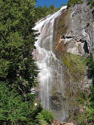
Fairy Falls is a waterfall in the Mount Rainier National Park in Pierce County, Washington. The falls are fed by an unnamed watercourse, which is a tributary of the Cowlitz River. The falls drop about 680 feet (210 m) into a narrow, wooden canyon in a horsetail form about 20 feet (6.1 m) wide.
Spray Falls is a waterfall in the Mount Rainier National Park in Pierce County, Washington. The falls are fed by Spray Creek, which is a tributary of the Puyallup River. The falls drop about 354 feet (108 m) into a talus slope in a vailed horsetail form about 100 feet (30 m) wide.

Deception Falls is a 94-foot (29 m) waterfall that flows from Deception Creek just over Stevens Pass, approximately 1856 feet above sea level, located in the U.S. state of Washington. Shortly downstream Deception Creek empties into Tye River. While flow may run dry in the late season, Deception Falls trail remains open in the Summer and Falls seasons. Deception Falls is located north of Interstate 90 in the Mount Baker–Snoqualmie National Forest. A hiking trail leads from a parking area to the falls.
Monkey Cage Falls is a 16-foot (4.9 m) waterfall that flows from Tye River just over Stevens Pass, approximately 1767 feet above sea level, located in the U.S. state of Washington. Access is usually approached with kayaks, a hiking trail leads from a parking area to Deception Falls upstream from which improvised trails lead to the edge of the Tye River with angled views of the waterfall.
