Paradise River waterfalls

Last updated

The Paradise River in Washington state, United States, is known for having a total of eight major waterfalls.

Contents

Paradise Falls

Paradise Falls
Location Mount Rainier, Pierce County, Washington
Type Segmented Block
Total height30 feet (9.1 m)
Number of drops1
Total width30 feet (9.1 m)
Watercourse Paradise River

Paradise Falls, at 46°47′54″N121°43′04″W / 46.79833°N 121.71778°W / 46.79833; -121.71778 , is the first waterfall on the Paradise River. The falls are a segmented block and are about 30 feet (9.1 m) high. The Skyline Trail crosses the river a mere 500 feet (150 m) downstream from the base of the falls, however, since off-trail travel isn’t allowed in the area, one has to settle with the mediocre views from the footbridge. [1]

Sluiskin Falls

Sluiskin Falls
Sluiskin Falls, Mount Rainier National Park (1912).jpg
Sluiskin Falls, c.1912
Location Mount Rainier, Pierce County, Washington
Type Fan
Total height180 feet (55 m)
Number of drops1
Total width50 feet (15 m)
Watercourse Paradise River

Sluiskin Falls, at 46°47′36″N121°43′02″W / 46.79333°N 121.71722°W / 46.79333; -121.71722 , is the second tallest waterfall on the Paradise. It is only 8 feet (2.4 m) shorter than Narada Falls. The falls occur where the river, still small at this point, drops into Paradise Valley. The falls are about 180 feet (55 m) high and about 50 feet (15 m) wide. [2]

Like Paradise Falls, it would be very easy to reach the base of the falls however, since off trail travel isn’t allowed, one has to stick with long distance views from the trail.

General Hazard Stevens and Philemon Beecher Van Trump were the ones who named the falls. They named it after a local Indian named Sluiskin who guided them to the first ascent of Mount Baker in 1870. [3]

Ruby Falls

Ruby Falls
Location Mount Rainier, Lewis County, Washington
Type Tiered
Total height30 feet (9.1 m)
Number of drops2
Total width20 feet (6.1 m)
Watercourse Paradise River

Ruby Falls, at 46°46′42″N121°44′21″W / 46.77833°N 121.73917°W / 46.77833; -121.73917 , is the first major waterfall on the Paradise River after it exits Paradise Valley. One of the most forgotten waterfalls in the area, Ruby Falls consists of 2 major tiers, first a 15-foot (4.6 m) cascade and then a 15-foot (4.6 m) plunge. There is a bridge situated between the 2 tiers. The falls are located about 200 feet (61 m) upstream from the top of the Washington Cascades. [4] [5]

The upper tier can easily be seen from the bridge while one can get good views of the lower tier by walking about 100 feet (30 m) downstream from the bridge along the Narada Falls Trail. [6]

Washington Cascades

Washington Cascades
Location Mount Rainier, Lewis County, Washington
Type Cascade
Total height100 feet (30 m)
Number of drops5
Total width10 feet (3.0 m)
Watercourse Paradise River

The Washington Cascades, at 46°46′41″N121°44′26″W / 46.77806°N 121.74056°W / 46.77806; -121.74056 , are a series of cascades along the Paradise River that start about 200 feet (61 m) downstream from the base of Ruby Falls. The falls are a long series of cascades that drop about 100 feet (30 m) over the stretch of 100 yards. No single drop is higher than 30 feet. [7] [8]

Henry Schwargel named the falls in 1893 for the state of Washington. [9] Some sources call the falls the "Washington Torrents" and one early postcard identified them as the "Seven Sisters Falls". [8]

Narada Falls

Sidewinder Cascades

Sidewinder Cascades
Location Mount Rainier, Lewis County, Washington
Type Cascade
Total height60 feet (18 m)
Number of drops3
Total width20 feet (6.1 m)
Watercourse Paradise River

The Sidewinder Cascades, at 46°46′24″N121°44′58″W / 46.77333°N 121.74944°W / 46.77333; -121.74944 , are a series of cascades a short distance downstream from Narada Falls. The falls are about 60 feet (18 m) high and drop that in 3 tiers, the bottom one being the largest at about 25 feet (7.6 m), dropping into a bunch of boulders. [4]

Madcap Falls

Madcap Falls
Location Mount Rainier, Lewis County, Washington
Type Cascade
Total height25 feet (7.6 m)
Number of drops1
Total width10 feet (3.0 m)
Watercourse Paradise River

Madcap Falls, at 46°45′55″N121°46′02″W / 46.76528°N 121.76722°W / 46.76528; -121.76722 , is a small 25-foot (7.6 m) high cascade located a short distance downstream from the mouth of Tatoosh Creek.

Most topo maps have placed Madcap Falls at incorrect locations along the river. Some show the falls right at the mouth of Tatoosh Creek, however it has been proved there is no waterfall there. There is a possibility that the waterfall currently known as Carter Falls is actually Madcap Falls, and Carter Falls lies further downstream. [4]

Carter Falls

Carter Falls
Location Mount Rainier, Lewis County, Washington
Type Plunge
Total height55 feet (17 m)
Number of drops1
Total width10 feet (3.0 m)
Watercourse Paradise River

Carter Falls, at 46°45′54″N121°46′07″W / 46.76500°N 121.76861°W / 46.76500; -121.76861 , is the final of the 9 waterfalls along the Paradise River. It is about 55 feet (17 m) tall and occurs when the river simply plunges 55 feet (17 m) out of a narrow chute. There is a small upper tier of an unknown height just above the main drop.

There is a possibility that the actual Carter falls lies further downstream and that the waterfall currently known as Carter Falls is Madcap Falls.

Henry Carter, who built the first trail to the Paradise Valley, named the falls between 1889 and 1900. [4]

See also

Related Research Articles

<span class="mw-page-title-main">Tahquamenon Falls</span> Series of waterfalls on the Tahquamenon River in Michigan, United States

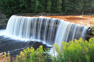
The Tahquamenon Falls are a series of waterfalls on the Tahquamenon River, shortly before it empties into Lake Superior, in the northeastern Upper Peninsula of Michigan. They are the largest waterfalls in Michigan, and one of the largest in the eastern half of North America. The water is noticeably brown in color from the tannins leached from the cedar swamps which the river drains, leading to the nickname "Root Beer Falls". The falls are within Tahquamenon Falls State Park, between the towns of Newberry and Paradise, and are a popular tourist destination during all seasons.

<span class="mw-page-title-main">Bonita Falls</span> Waterfall in California, United States

Bonita Falls are a set of waterfalls in the San Bernardino National Forest, formed by Bonita Creek, that is said to be 370 or 400 feet in height, but possibly up to 495 feet high because of two undocumented drops in the canyon above. It is the second tallest in the national forest, being surpassed only by 500-foot (150 m) Big Falls. These two waterfalls are reputably the tallest in southern California.

<span class="mw-page-title-main">Bridal Veil Falls (Washington)</span> Waterfall in Washington (state), United States

Bridal Veil Falls is a 1,328-foot (405 m) waterfall that flows from Lake Serene directly to the South Fork Skykomish River on the creek of the same name in the U.S. state of Washington. It is a perennial 150-foot (46 m) wide drop with four tiers, two of which are clearly visible. It is at 47.78950°N 121.56924°W.

Foss River Falls is a 650-foot (200 m) drop on the West Fork Foss River in the Alpine Lakes Wilderness Area, King County, Washington. Its sources are at Delta Lake, and the 70-foot (21 m)-wide drop flows year-round. The waterfall is split into two parts. Each part is split into several tiers.

<span class="mw-page-title-main">Mount Shuksan Waterfalls</span> Waterfall in Washington, United States

There are four prominent waterfalls in the basin of a short tributary of Sulphide Creek, on the southeast flank of 9,127-foot (2,781m) Mount Shuksan in North Cascades National Park, Washington. Seahpo Peak Falls and Cloudcap Falls, the taller two of the three, are located on separate streams that converge and plunge over Rockflow Canyon Falls. The unnamed outlet stream from these waterfalls flows into Sulphide Creek, which flows into the Baker River. Another waterfall is Jagged Ridge Falls, on a tributary of the unnamed stream.

Wy'east Falls is a waterfall on a small tributary of Eagle Creek in Hood River County, Oregon, U.S.

Walupt Creek Falls is a relatively obscure, but massive waterfall on Walupt Creek, a large tributary of the Cispus River in Lewis County, Washington, at an elevation of 3,500 feet (1,100 m). The falls cascade 221 feet (67 m) down a bedrock cliff in two tiers, with an average breadth of 204 feet (62 m), a maximum breadth of 267 feet (81 m) and an average flow of over 150 cubic feet (4.2 m3) per second. The creek begins the drop by falling down a 10 feet (3.0 m) cascade, then impacts a large, bell-shaped dome and spreads into a wide fan, dropping 200 feet (61 m). The final drop is a gently sloping slide that flows directly into the Cispus River. The feeder river, Walupt Creek, is sourced directly from Walupt Lake which provides a consistent flow throughout the year. The drainage basin of the river is also fairly large.

<span class="mw-page-title-main">Van Trump Creek</span> River in Washington, United States

Van Trump Creek, also called Van Trump Falls Creek or the Van Trump Fork of the Nisqually River, is a creek in Pierce County, Washington. It is a tributary of the Nisqually River, joining the river just above the mouth of the Paradise River. The creek is known for having several well known waterfalls along its course.

<span class="mw-page-title-main">Comet Falls</span> Waterfall in Washington (state), United States

Comet Falls is a tall waterfall located on Van Trump Creek in Pierce County, Washington. The falls are thought to be the best in the Mount Rainier region.

<span class="mw-page-title-main">Van Trump Falls</span> Waterfall in Washington (state), United States

Van Trump Falls is a waterfall on Van Trump Creek in Pierce County, Washington. The falls are located a short distance downstream from the mouth of Falls Creek.

There are a total of 3 waterfalls on the 2 forks of the Miller River. Below is a description for all of them:

<span class="mw-page-title-main">Paradise River</span> River in Washington, United States

For the Canadian community, see Paradise River, Newfoundland and Labrador

Big Heart Falls is a waterfall on the outlet stream of Big Heart Lake, which eventually flows into the Skykomish River, in King County, Washington. It is located between the outlet of Big Heart Lake and the inlet of Delta Lake. The falls are said to drop approximately 1,268 feet (386 m).

<span class="mw-page-title-main">Eagle Creek waterfalls</span>

Eagle Creek is a tributary of the Columbia River in Multnomah and Hood River counties in the U.S. state of Oregon. It cuts through a narrow canyon in its 3,200 feet (980 m) descent to the Columbia River Gorge and is known for its concentration of 13 waterfalls in about 5 miles (8.0 km) distance. Eight major falls are on Eagle Creek and the East Fork Eagle Creek itself, while five are on its tributaries.

There are multiple waterfalls in the basin of the North Fork Cascade River, a river in the North Cascades of Washington that drains to the Cascade River. Many of these are taller than the more famous waterfalls in North America, but do not receive much attention due to their remoteness.

<span class="mw-page-title-main">Narada Falls</span> Waterfall in Washington (state), United States

Narada Falls is a waterfall in Mount Rainier National Park, in the U.S. state of Washington. It is said to be the most popular, because the Mount Rainier Highway crosses the falls between its two tiers.

Sydney Falls, more commonly called Kotsuck Creek Falls or Kotsuck Falls, is a waterfall in the Mount Rainier National Park in the U.S. state of Washington.

The valley of the West Fork Foss River contains a fair amount of waterfalls. The river heads in a series of large lakes: Big Heart Lake, Angeline Lake, and Otter Lake- which form spectacular waterfalls as they plunge down to Delta Lake. On the valley walls downstream of Delta Lake, are found even more waterfalls.

The Little Mashel River Waterfalls are the three waterfalls contained within the gorge of the Little Mashel River, not far above its confluence with the Mashel River.

References

  1. "Paradise Falls". Waterfalls of the Pacific Northwest.
  2. "Sluiskin Falls". Aaron's Waterfall World.
  3. Swan, Bryan. "Sluiskin Falls". Waterfalls of the Pacific Northwest.
  4. 1 2 3 4 "Northwest Waterfall Survey". www.waterfallsnorthwest.com.
  5. "Ruby Falls - Waterfalls of the Northeastern United States". www.northeastwaterfalls.com.
  6. "Ruby Falls". aaronswaterfallworld.tripod.com.
  7. "Washington Cascades (Aaron's Waterfall World". aaronswaterfallworld.com).
  8. 1 2 "Washington Cascades - Northwest Waterfall Survey". www.waterfallsnorthwest.com. Retrieved 2023-10-27.
  9. "Washington Cascades". Washington Place Names. Tacoma Public Library Online Digital Collections. Retrieved 2023-10-27.