Paradise River

Last updated
Paradise River
River
Paradise River 8217.JPG
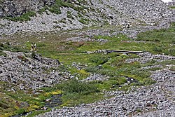
Paradise River at the Skyline Trail Bridge
Country United States
State Washington
Counties Pierce County, Lewis County
Source Paradise Glacier
 - location Mount Rainier
Mouth Nisqually River

The Paradise River is a small, short but swift river in Pierce County, Washington. It is the first major tributary of the Nisqually River. Located entirely within the bounds of Mount Rainier National Park, it is notable for its waterfalls, of which there are eight.

River Natural flowing watercourse

A river is a natural flowing watercourse, usually freshwater, flowing towards an ocean, sea, lake or another river. In some cases a river flows into the ground and becomes dry at the end of its course without reaching another body of water. Small rivers can be referred to using names such as stream, creek, brook, rivulet, and rill. There are no official definitions for the generic term river as applied to geographic features, although in some countries or communities a stream is defined by its size. Many names for small rivers are specific to geographic location; examples are "run" in some parts of the United States, "burn" in Scotland and northeast England, and "beck" in northern England. Sometimes a river is defined as being larger than a creek, but not always: the language is vague.

Pierce County, Washington County in the United States

Pierce County is a county in the U.S. state of Washington. As of the 2010 Census, the population was 795,225, making it the second-most populous county in Washington behind King County, and the 63rd-most populous in the United States. The county seat and largest city is Tacoma. Formed out of Thurston County on December 22, 1852, by the legislature of Oregon Territory, it was named for U.S. President Franklin Pierce. Pierce County is in the Seattle metropolitan area.

Washington (state) State of the United States of America

Washington, officially the State of Washington, is a state in the Pacific Northwest region of the United States. Named for George Washington, the first president of the United States, the state was made out of the western part of the Washington Territory, which was ceded by Britain in 1846 in accordance with the Oregon Treaty in the settlement of the Oregon boundary dispute. It was admitted to the Union as the 42nd state in 1889. Olympia is the state capital; the state's largest city is Seattle. Washington is sometimes referred to as Washington State to distinguish it from Washington, D.C., the capital of the United States.

Contents

Course

The Paradise River originates at the toe of the Paradise Glacier. It drops over Paradise Falls and Sluiskin Falls as it drops swiftly downhill into Paradise Valley. Just before entering the valley it receives Edith Creek, which also has many waterfalls along its course. From there, the river flows generally southwest. After flowing out of Paradise Valley, the river drops over Ruby Falls and the Washington Cascades. Not long after that, the river widens out and drops over probably the most famous and well known waterfall in the Mount Rainier area, Narada Falls, and soon after is crossed by the Mount Rainier Highway. Narada Falls is soon followed by the seldom-seen Sidewinder Cascades. A ways past Narada Falls, the river drops over Madcap Falls before it is joined soon after by Tatoosh Creek, which also has more than one major waterfall along its course. After that the river turns west, drops over Carter Falls soon after, and makes its final push toward its confluence with the Nisqually River.

Paradise Glacier glacier in the United States

Paradise Glacier is a glacier on the southeast flank of Mount Rainier in Washington. It covers 0.4 square miles (1.0 km2) and contains 0.8 billion ft3 with Stevens Glacier included. The glacier is bounded to the west by the Muir Snowfield, Anvil Rock and McClure Rock. There is a single extant main lobe of the glacier, ranging from 9,000 feet (2,700 m) to 7,200 feet (2,200 m), that is connected to the larger Cowlitz Glacier. To the south, there was a smaller portion which was near the Cowlitz Rocks and the tiny Williwakas Glacier, ranging from 6,900 feet (2,100 m) to 6,400 ft (2,000 m) in elevation and containing the Paradise Ice Caves until the 1990s. This smaller lobe melted between 2004 and 2006. Meltwater from the glacier drains into the Cowlitz River.

Mount Rainier stratovolcano in the U.S. state of Washington

Mount Rainier, also known as Tahoma or Tacoma, is a large active stratovolcano located 59 miles (95 km) south-southeast of Seattle, in the Mount Rainier National Park. With a summit elevation of 14,411 ft (4,392 m), it is the highest mountain in the U.S. state of Washington, and of the Cascade Range of the Pacific Northwest, it is the most topographically prominent mountain in the continental United States and the first in the Cascade Volcanic Arc.

Narada Falls waterfall

Narada Falls is a waterfall in Mount Rainier National Park, in the U.S. state of Washington. It is said to be the most popular, because the Mount Rainier Highway crosses the falls between its two tiers.

See also

Commons-logo.svg Media related to Paradise River at Wikimedia Commons

Coordinates: 46°45′52″N121°47′24″W / 46.76444°N 121.79000°W / 46.76444; -121.79000

Geographic coordinate system Coordinate system

A geographic coordinate system is a coordinate system that enables every location on Earth to be specified by a set of numbers, letters or symbols. The coordinates are often chosen such that one of the numbers represents a vertical position and two or three of the numbers represent a horizontal position; alternatively, a geographic position may be expressed in a combined three-dimensional Cartesian vector. A common choice of coordinates is latitude, longitude and elevation. To specify a location on a plane requires a map projection.


Related Research Articles

Cascade Range mountain range in western North America

The Cascade Range or Cascades is a major mountain range of western North America, extending from southern British Columbia through Washington and Oregon to Northern California. It includes both non-volcanic mountains, such as the North Cascades, and the notable volcanoes known as the High Cascades. The small part of the range in British Columbia is referred to as the Canadian Cascades or, locally, as the Cascade Mountains. The latter term is also sometimes used by Washington residents to refer to the Washington section of the Cascades in addition to North Cascades, the more usual U.S. term, as in North Cascades National Park. The highest peak in the range is Mount Rainier in Washington at 14,411 feet (4,392 m).

Mount Rainier National Park national park of the United States

Mount Rainier National Park is an American national park located in southeast Pierce County and northeast Lewis County in Washington state. The park was established on March 2, 1899 as the fifth national park in the United States, preserving 236,381 acres including all of Mount Rainier, a 14,411-foot (4,392 m) stratovolcano. The mountain rises abruptly from the surrounding land with elevations in the park ranging from 1,600 feet to over 14,000 feet. The highest point in the Cascade Range, Mount Rainier is surrounded by valleys, waterfalls, subalpine meadows, and 91,000 acres of old-growth forest. More than 25 glaciers descend the flanks of the volcano, which is often shrouded in clouds that dump enormous amounts of rain and snow.

Snoqualmie River river in the United States of America

The Snoqualmie River is a 45-mile (72 km) long river in King County and Snohomish County in the U.S. state of Washington. The river's three main tributaries are the North, Middle, and South Forks, which drain the west side of the Cascade Mountains near the town of North Bend and join near the town of Snoqualmie just above the Snoqualmie Falls. After the falls the river flows north through rich farmland and the towns of Fall City, Carnation, and Duvall before meeting the Skykomish River to form the Snohomish River near Monroe. The Snohomish River empties into Puget Sound at Everett. Other tributaries of the Snoqualmie River include the Taylor River and the Pratt River, both of which enter the Middle Fork, the Tolt River, which joins at Carnation, and the Raging River at Fall City.

Yakama ethnic group

The Yakama are a Native American tribe with nearly 10,851 members, based primarily in eastern Washington state.

Sauk River (Washington) river in Washington

The Sauk River is a tributary of the Skagit River, approximately 45 miles (72 km) long, in northwestern Washington in the United States. It drains an area of the high Cascade Range in the watershed of Puget Sound north of Seattle. The river is a popular destination for fly fishing. It is a National Wild and Scenic River.

Nisqually River river in the United States of America

The Nisqually River is a river in west central Washington in the United States, approximately 81 miles (130 km) long. It drains part of the Cascade Range southeast of Tacoma, including the southern slope of Mount Rainier, and empties into the southern end of Puget Sound. Its outlet was designated in 1971 as the Nisqually Delta National Natural Landmark.

Mowich River river in the United States of America

The Mowich River is a river in the U.S. state of Washington. Its watershed drains a portion of the western side of Mount Rainier, part of the Cascade Range. The river has two main headwater branches, the South Mowich River and the North Mowich River. The South Mowich is significantly larger and sometimes considered the main river. The Mowich and its tributaries drain several of Mount Rainier's glaciers. The upper portion of its watershed is contained within Mount Rainier National Park. The river flows into the Puyallup River in the foothills west of Mount Rainier.

Foss River Falls is a 650-foot (200 m) drop on the West Fork Foss River in the Alpine Lakes Wilderness Area, King County, Washington. Its sources are at Delta Lake, and the 70-foot (21 m)-wide drop flows year-round. The waterfall is split into two parts. Each part is split into several tiers.

Mount Shuksan Waterfalls waterfalls at Mount Shuksan

There are four prominent waterfalls in the basin of a short tributary of Sulphide Creek, on the southeast flanc of 9,127-foot (2,781m) Mount Shuksan in North Cascades National Park, Washington. Seahpo Peak Falls and Cloudcap Falls, the taller two of the three, are located on separate streams that converge and plunge over Rockflow Canyon Falls. The unnamed outlet stream from these waterfalls flows into Sulphide Creek, which flows into the Baker River. Another waterfall is Jagged Ridge Falls, on a tributary of the unnamed stream.

The Taylor River is a river in King County in Washington.

Depot Creek (BC-Washington) river in United States of America

Depot Creek, also known as Brown Creek and Kokanee Creek, is a large creek in south-central British Columbia, Canada and Whatcom County, Washington, United States. It is in the Pacific Ocean drainage basin, and is located in the North Cascades. There is a waterfall along its course, Depot Creek Falls.

Van Trump Creek stream in Washington, United States

Van Trump Creek, also called Van Trump Falls Creek or the Van Trump Fork of the Nisqually River, is a creek in Pierce County, Washington. It is a tributary of the Nisqually River, joining the river just above the mouth of the Paradise River. The creek is known for having several well known waterfalls along its course.

Comet Falls waterfall

Comet Falls is a tall waterfall located on Van Trump Creek in Pierce County, Washington. The falls are thought to be the best in the Mount Rainier region.

Wells Creek

Wells Creek is a swift creek in Whatcom County, Washington. It is a tributary of the Nooksack River, joining the river just below Nooksack Falls. It is best known for having six major waterfalls along its course. Wells Creek was named for Hamilton C. Wells who prospected the area in the 1880s and 1890s.

Kautz Creek

Kautz Creek is a tributary of the Nisqually River, flowing from the Kautz Glacier, with its watershed in the Mount Rainier National Park of Washington. It drains southwest from Mount Rainier for about 6 miles (9.7 km) before it joins the Nisqually River near Mount Rainier Highway. It is notable for being a severe flooding hazard due to the volume of summer glacier melt and its frequently changing course. The 400-foot (120 m) Kautz Creek Falls on the headwaters of the creek was formed by the retreat of the Kautz Glacier in the past 50 years.

Eagle Creek waterfalls

Eagle Creek is a tributary of the Columbia River in Multnomah and Hood River counties in the U.S. state of Oregon. It cuts through a narrow canyon in its 3,200 feet (980 m) descent to the Columbia River Gorge and is known for its concentration of 13 waterfalls in about 5 miles (8.0 km) distance. Eight major falls are on Eagle Creek and the East Fork Eagle Creek itself, while five are on its tributaries.

There are multiple waterfalls in the basin of the North Fork Cascade River, a river in the North Cascades of Washington that drains to the Cascade River. Many of these are taller than the more famous waterfalls in North America, but do not receive much attention due to their remoteness.

Pearl Falls

Pearl Falls is one of the highest waterfalls in Mount Rainier National Park in the U.S. state of Washington. It is fed by the glacial Pearl Creek, occurring about halfway along the creek's course.

The Paradise River is known for having a total of 8 major waterfalls.