Cowlitz River

Last updated
Cowlitz River
Cowlitz River During Smelt Run.jpg
The Cowlitz River at Kelso, Washington
Cowlitzmap.png
Map of the Cowlitz River watershed
USA Washington relief location map.jpg
Red pog.svg
Mouth of the Cowlitz River in Washington
Etymologyfrom the Salish, tawallitch, perhaps meaning "capturing the medicine spirit" [1]
Location
CountryUnited States
State Washington
Region Lewis County, Cowlitz County
Cities Packwood, Randle, Mossyrock, Toledo, Castle Rock, Longview, Kelso
Physical characteristics
Source 
  location Packwood
  coordinates 46°39′16″N121°37′13″W / 46.65444°N 121.62028°W / 46.65444; -121.62028 [2]
  elevation1,190 ft (360 m) [3]
Mouth Columbia River
  location
Longview
  coordinates
46°5′52″N122°54′40″W / 46.09778°N 122.91111°W / 46.09778; -122.91111 Coordinates: 46°5′52″N122°54′40″W / 46.09778°N 122.91111°W / 46.09778; -122.91111 [2]
  elevation
3 ft (0.91 m) [2]
Length105 mi (169 km)
Basin size2,586 sq mi (6,700 km2)
Discharge 
  location Castle Rock [4]
  average9,122 cu ft/s (258.3 m3/s) [4]
  minimum998 cu ft/s (28.3 m3/s)
  maximum139,000 cu ft/s (3,900 m3/s)
Basin features
Tributaries 
  leftCispus River, Toutle River
  rightTilton River

The Cowlitz River is a river in the state of Washington in the United States, a tributary of the Columbia River. Its tributaries drain a large region including the slopes of Mount Rainier, Mount Adams, and Mount St. Helens.

Contents

The Cowlitz has a 2,586-square-mile (6,698 km2) drainage basin, [5] [6] located between the Cascade Range in eastern Lewis County, Washington and the cities of Kelso and Longview. The river is roughly 105 miles (169 km) long, not counting tributaries.

Major tributaries of the Cowlitz River include the Cispus River and the Toutle River, which was overtaken by volcanic mudflows (lahars) during the May 1980 eruption of Mount St. Helens.

When the smelt spawn in the Cowlitz River, the gulls go into a feeding frenzy that lasts for weeks. Kelso, Washington is known as the "Smelt Capital of the World". [7]

Dams

The Cowlitz River has three major hydroelectric dams, with several small-scale hydropower and sediment retention structures within the Cowlitz Basin.

The Cowlitz Falls Project is a 70 megawatt hydroelectric dam built in the early 1990s and completed in 1994. The dam is 140 feet (43 m) high and 700 feet (210 m) wide. The Cowlitz Falls Project produces on average 260 GWh annually for Lewis County PUD. Its reservoir, Lake Scanewa, is located at the confluence of the Cowlitz and Cispus Rivers downstream of Randle.

Mossyrock Dam began generating power for Tacoma City Light in 1968. It rises 605 feet (184 m) from bedrock and created the 23-mile (37 km) long Riffe Lake (previously Davisson Reservoir). It is the highest dam in the Pacific Northwest. [8] The dam is named for the nearby city of Mossyrock, and the lake for the town of Riffe, which, along with Kosmos, was destroyed by the flooding of the Cowlitz River valley above the dam.

The Mayfield Dam is 850 feet (260 m) long and 185 feet (56 m) high. An 860-foot (260 m) tunnel connects the reservoir to the powerhouse. The dam began producing electricity in 1963. Mayfield Lake offers many recreational opportunities: there are several county and state parks and the lake is below the Mossyrock Dam. The modulated inflow from the Mossyrock Dam allows Mayfield Lake to maintain a water level that rarely fluctuates more than a few feet. It is located several miles downstream of Mossyrock.

Packwood Lake was dammed in 1964 by the Washington Public Power Supply System (now called Energy Northwest). The dam holds back the lake (previously held back by an ancient landslide), redirecting streamflow to a 27 megawatt hydroelectric generator in the Cowlitz River valley floor 2,000 feet (600 m) below just outside the town of Packwood. When designing and building the dam, care was taken so as not to affect the abundant wildlife of the lake and surrounding area: the dam raised the water level by only a few feet.
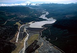
The sediment retention structure on the North Fork of the Toutle River. The dam is approximately 22 miles (35 km) upriver from the confluence of the Toutle and the Cowlitz. USACE sediment retention structure Toutle River.jpg
The sediment retention structure on the North Fork of the Toutle River. The dam is approximately 22 miles (35 km) upriver from the confluence of the Toutle and the Cowlitz.

A serious side effect of the Mount St. Helens 1980 eruption has been the downstream movement of enormous amounts of sediment through the North Fork Toutle River. After the eruption, river-borne sediment increased over five thousand-fold, making the Toutle River one of the most sediment-laden rivers in the world.[ citation needed ] The Toutle River Sediment Retention Structure was constructed to trap this sediment before it was carried farther downstream, where it could clog the river channel, exacerbate floods along the lower Toutle and Cowlitz Rivers, and fill the Columbia River shipping channel, which still requires periodic dredging. An overflow channel has been added to divert lahars around the dam.

Bridges

The Box Canyon of the Cowlitz, viewed from a bridge in Mount Rainier National Park. The bottom of this panorama looks approximately 180 feet (55 m) straight down. Box Canyon of the Cowlitz, Mount Rainier National Park, Trans-Mercator projection pano 01.jpg
The Box Canyon of the Cowlitz, viewed from a bridge in Mount Rainier National Park. The bottom of this panorama looks approximately 180 feet (55 m) straight down.

Numerous road and rail bridges span the Cowlitz.

Just upstream from its mouth at the Columbia river, a railroad bridge connecting the Port of Longview to the BNSF rail line crosses the Cowlitz, with a road bridge for SR 432 (Tennant Way) beside.

Further upstream are the Allen St. and Cowlitz Way bridges, connecting West Kelso with the rest of Kelso. Just north of Kelso, a railroad bridge provides crossing for the Columbia & Cowlitz Railroad.

Connecting SR 411 to Interstate-5 is the Lexington bridge, a two-lane bridge between the large unincorporated community of Lexington to Exit 42 on the east side of the bank.

At Castle Rock, the A St. bridge provides access from downtown to the school and residential areas across the river. A few miles north, after the Toutle River split, the BNSF line crosses the river.

Across the Lewis/Cowlitz County line, between the towns of Vader and Toledo, Washington, I-5 crosses the river. At Toledo, SR-505 crosses the river as well.

Where Highway 12 crosses Mayfield Lake, just west of Mossyrock, causeways were built out to the middle of the lake, where a short bridge section connects the two sides. A small bridge provides a crossing for SR 122 at the head of Mayfield Lake. Just east of Mossyrock, the Cowlitz River Bridge on Highway 12 was the largest concrete arch bridge in North America until 1971 at 550 feet (170 m).

USGS stream gaging stations on the Cowlitz River Cowlitz.gif
USGS stream gaging stations on the Cowlitz River

At the head of Riffe Lake, the 27 Road provides access to the forestland south of the Cowlitz from Morton and Glenoma to the north.

At Randle, SR 131 crosses the Cowlitz to provide access to the Cispus basin and the northern areas of the Mount St. Helens National Volcanic Monument.

Between Randle and Packwood, Highway 12 crosses the Cowlitz at the Cora bridge.

At Packwood, Skate Creek Road spans the river, providing access to the Gifford Pinchot National Forest and Tatoosh Wilderness, as well as connecting the downtown and residential areas of Packwood.

Upstream from Packwood, the Cowlitz splits into the Muddy and Clear Forks, with several Forest Service and Park Service roads crossing each.

Other river structures

When the Cowlitz Salmon Hatchery began operation in 1968, it was the largest of its kind in the world. Currently, it produces nearly 13 million fish each year. Adjacent is the barrier dam, which diverts spawning and upriver migrating fish to a separating station where fish are sorted by species. Some of the fish are used by the hatchery while others are transported upstream to continue migration.

The Bonneville Power Administration, in cooperation with the Lewis County PUD, state and federal agencies and Tacoma Power, constructed a downstream anadromous fish collection facility as part of the Cowlitz Falls Project. The fish facility, along with the Cowlitz River Salmon Hatchery's diversion dam below Mayfield Lake, has permitted the reintroduction of salmon and steelhead in the upper Cowlitz River basin for the first time since the construction of the Mossyrock and Mayfield dams in the 1960s.

Main tributaries

Recreation

The Cowliz River's two hatcheries provide an exceptional sportfishing opportunity for recreational anglers in Washington and Oregon. The river consistently ranks as one of the states top ten steelhead and salmon producers.

See also

Related Research Articles

<span class="mw-page-title-main">Yakama</span> Ethnic group

The Yakama are a Native American tribe with nearly 10,851 members, based primarily in eastern Washington state.

<span class="mw-page-title-main">Rogue River (Oregon)</span> River in Oregon, United States

The Rogue River in southwestern Oregon in the United States flows about 215 miles (346 km) in a generally westward direction from the Cascade Range to the Pacific Ocean. Known for its salmon runs, whitewater rafting, and rugged scenery, it was one of the original eight rivers named in the Wild and Scenic Rivers Act of 1968. Beginning near Crater Lake, which occupies the caldera left by the explosive volcanic eruption and collapse of Mount Mazama, the river flows through the geologically young High Cascades and the older Western Cascades, another volcanic province. Further west, the river passes through multiple exotic terranes of the more ancient Klamath Mountains. In the Kalmiopsis Wilderness section of the Rogue basin are some of the world's best examples of rocks that form the Earth's mantle. Near the mouth of the river, the only dinosaur fragments ever discovered in Oregon were found in the Otter Point Formation, along the coast of Curry County.

<span class="mw-page-title-main">Elwha River</span> River in Washington, United States

The Elwha River is a 45-mile (72 km) river on the Olympic Peninsula in the U.S. state of Washington. From its source at Elwha snowfinger in the Olympic Mountains, it flows generally north to the Strait of Juan de Fuca. Most of the river's course is within the Olympic National Park.

<span class="mw-page-title-main">North Fork Toutle River</span> River in Washington, United States

The North Fork Toutle River is a tributary of the Toutle River in southwestern Washington in the United States. The river has its headwaters near Spirit Lake, on the north side of Mount St. Helens, and flows 39 miles (63 km) to the Toutle River, about 17 miles (27 km) upstream of its confluence with the Cowlitz River. The largest tributary is the Green River, which joins near the unincorporated town of Toutle.

<span class="mw-page-title-main">Washington State Route 504</span> Highway in Washington

State Route 504 is a state highway in southwestern Washington state in the United States. It travels 52 miles (84 km) along the North Fork Toutle River to the Mount St. Helens area, serving as the main access to the Mount St. Helens National Volcanic Monument. The highway begins at an interchange with Interstate 5 (I-5) and SR 411 in Castle Rock and terminates at the Johnston Ridge Observatory near Spirit Lake.

<span class="mw-page-title-main">Capilano River</span> River in British Columbia, Canada

The Capilano River flows from north to south through the Coast Mountains on Vancouver's North Shore between West Vancouver and North Vancouver and empties into Burrard Inlet, opposite Stanley Park. The river is one of three primary sources of drinking water for residents of Greater Vancouver, and flows through the Capilano watershed. The Cleveland Dam, built in 1954, impounds a reservoir for this purpose. The entire area of the reservoir and watershed area upstream of the dam is closed to the public to ensure the quality of the drinking water. Prior to construction of the Cleveland Dam, the Capilano River deposited large amounts of sediment into Burrard Inlet. A dredge was needed to remove this sediment build-up in order to keep Burrard Inlet open for ship traffic.

<span class="mw-page-title-main">Lake Mayfield</span> Lake in Washington state, U.S.

Lake Mayfield is a reservoir located near Mossyrock, Washington, in Lewis County. It was created by Mayfield Dam on the Cowlitz River, one of the dams in the Columbia River watershed.

<span class="mw-page-title-main">Toutle River</span> River in Washington, United States

The Toutle River is a 17.2-mile (27.7 km) tributary of the Cowlitz River in the U.S. state of Washington. It rises in two forks merging near Toutle below Mount St. Helens and joins the Cowlitz near Castle Rock, 20 miles (32 km) upstream of the larger river's confluence with the Columbia River.

<span class="mw-page-title-main">Cispus River</span> River in Washington, United States

The Cispus River is about 54 miles (87 km) long and flows into the Cowlitz River at Lake Scanewa in the Cascade Range of Washington. Its tributaries drain most of south-central and southeastern Lewis County, extreme northeast Skamania County, and some of western Yakima County.

<span class="mw-page-title-main">Baker River (Washington)</span> River in Washington, United States

The Baker River is an approximately 30-mile (48 km), southward-flowing tributary of the Skagit River in northwestern Washington in the United States. It drains an area of the high North Cascades in the watershed of Puget Sound north of Seattle, and east of Mount Baker. With a watershed of approximately 270 square miles (700 km2) in a complex of deep valleys partially inside North Cascades National Park, it is the last major tributary of the Skagit before the larger river reaches its mouth on Skagit Bay. The river flows through Concrete, Washington, near its mouth and has two hydroelectric dams owned by Puget Sound Energy.

<span class="mw-page-title-main">Toutle River Sediment Retention Structure</span> Dam in Washington, United States

The Sediment Retention Structure is an earthen dam, 1,888 feet (575 m) long and 184 feet (56 m) high, on the North Fork Toutle River in the U.S. state of Washington. Completed by the United States Army Corps of Engineers in 1989, it is meant to prevent sediment from the 1980 eruption of Mount St. Helens from increasing flood risks along the Toutle and Cowlitz rivers.

<span class="mw-page-title-main">Sanpoil River</span> River in Okanagan Highlands, United States

The Sanpoil River is a tributary of the Columbia River, in the U.S. state of Washington. The river is named for the Sanpoil, the Interior Salish people who live along the river course. The name is from the Okanagan term [snpʕʷílx], meaning "people of the gray country", or "gray as far as one can see".

<span class="mw-page-title-main">Kosmos, Washington</span> Flooded town

Kosmos was an unincorporated community in Lewis County, Washington, southwest of Glenoma and is now considered a flooded town. Kosmos is named from a Greek term meaning "the world or universe as an embodiment of order and harmony".

<span class="mw-page-title-main">Mossyrock Dam</span> Dam in Washington state

Mossyrock Dam is a concrete arch-gravity dam on the Cowlitz River near Mossyrock in Lewis County, Washington. The reservoir created by the dam is called Riffe Lake and the primary purpose of the dam is hydroelectric production while flood control is secondary. The dam is the tallest in Washington State and its hydroelectric power station supplies 40% of Tacoma Power's electricity.

<span class="mw-page-title-main">Riffe Lake</span> Body of water

Riffe Lake is a 23.5 mi (38 km) long reservoir on the Cowlitz River in the U.S. state of Washington. It was created in 1968 with the construction of Mossyrock Dam by Tacoma City Light. Originally named Mossyrock Lake, then later as Davisson Lake after a utilities commissioner in Tacoma, the lake was renamed in 1976 after the community of Riffe, which was inundated by the lake. The residents of Kosmos and Nesika were also relocated as the lake's water level would submerge all of Nesika and much of Kosmos.

<span class="mw-page-title-main">Nanaimo River</span> River on Vancouver Island, Canada

The Nanaimo River is a river on Vancouver Island, British Columbia, Canada, located near the city of Nanaimo on the island's east coast. Its headwaters are in the Vancouver Island Ranges of central Vancouver Island and its mouth, the Nanaimo River estuary, is at the south end of Nanaimo Harbour in the Strait of Georgia. The estuary is part of the Pacific Estuary Conservation Program.

<span class="mw-page-title-main">Coldwater Lake (Washington)</span> Body of water

Coldwater Lake is a barrier lake on the border of Cowlitz County and Skamania County, Washington in the United States. The lake was created during the 1980 eruption of Mount St. Helens, which blocked its natural outlet, Coldwater Creek, with volcanic debris. It is one of several lakes in the area that were created or otherwise enlarged by the eruption.

References

  1. Phillips, James W. (1971). Washington State Place Names . Seattle and London: University of Washington Press. pp.  33. ISBN   0-295-95498-1.
  2. 1 2 3 U.S. Geological Survey Geographic Names Information System: Cowlitz River, USGS, GNIS
  3. Google Earth elevation for GNIS coordinates.
  4. 1 2 Water Resources Data, Washington, 2005, USGS
  5. Lower Columbia Tributaries Archived 2008-10-02 at the Wayback Machine , Northwest Power and Conservation Council
  6. Toutle Management Plan Archived 2008-10-02 at the Wayback Machine , Northwest Power and Conservation Council
  7. Fischer, Amy M. E. "Four things that helped define Kelso". Longview Daily News. Retrieved 2019-12-20.
  8. Cowlitz River Project Archived 2005-11-16 at the Wayback Machine , Tacoma Power