
The geography of France consists of a terrain that is mostly flat plains or gently rolling hills in the north and west and mountainous in the south and the east.

Soyuz TM-22 was the 23rd manned spacecraft mission to visit the Soviet Space Station Mir.

The European route E 22 is one of the longest European routes. It has a length of about 5,320 km (3,310 mi). Many of the E-roads have been extended into Asia since the year 2000; the E 22 was extended on 24 June 2002.

Hohoe Municipal is one of the 25 administrative districts of the Volta Region of Ghana. It was carved out of the former Kpando District. It was established by the Legislative Instrument of 2012. The Municipality has a total land area of 1,172 km2, which is 5.6 percent of the land area of the region. It shares borders with the Republic of Togo on the east, forming part of Ghana's international border; on the southeast by the Afadzato district and southwest by Kpando Municipality; on the north with Jasikan district; and on the northwest with the Biakoye districts. Its capital, Hohoe, is about 78 kilometres from Ho, the regional capital and 220 km from Accra, the national capital. The population of Hohoe Municipality, according to the 2010 Population and Housing Census, is 167,016 representing 7.9 percent of the total population of the Volta Region. It comprises 52.1 percent females and 47.9 percent males

Teluk Ramunia is a town in Kota Tinggi District, Johor, Malaysia. It is a well-known bauxite mining town in the early days of Malaysia. It is a sight seeing place, good for a family picnic spot. Now it is known for Oil and Gas Fabrication industries.

Advanced Landing Grounds (ALGs) were temporary advance airfields constructed by the Allies during World War II during the liberation of Europe. They were built in the UK prior to the invasion and thereafter in northwest Europe from 6 June 1944 to V-E Day, 7 May 1945.
Mansfeld-Südharz is a district in Saxony-Anhalt, Germany.

Sharnal Street station was a railway station between High Halstow Halt and Beluncle Halt on the Hundred of Hoo Railway. It was opened on 1 April 1882 and closed to passengers on 4 December 1961 and freight on 20 August 1962. It originally only had one platform, a second platform was built in 1935. The station buildings were demolished in 1967.
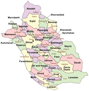
Rostam County is a county in Fars Province in Iran. The capital of the county is Masiri. At the 2006 census, the county's population was 45,377, in 9,134 families. The county is subdivided into two districts: the Central District and Sorna District. The county has two cities: Masiri & Kupon.

Lesnes Abbey Woods, sometimes known as Abbey Wood, is an area of ancient woodland in southeast London, England. It is located near to, and named after, the ruined Lesnes Abbey in the London Borough of Bexley and gives its name to the Abbey Wood district. The woods are adjacent to Bostall Woods.

Duchesse Anne is the last remaining full-rigged ship under French flag. She was built in 1901 with a steel hull by the yard of Joh. C. Tecklenborg of Bremerhaven-Geestemünde (Germany) according to plans drawn by Georg W. Claussen. The mainmast is 48 m tall and 25 sails were rigged. She was used as a training ship for young aspiring sailors in the German merchant marine.
Metyal is a village in Belgaum district of Karnataka, India.
Kopli is a village in Saaremaa Parish, Saare County in western Estonia.
Nava is a village in Saaremaa Parish, Saare County in western Estonia.
Liivaranna is a village in Mustjala Parish, Saare County in western Estonia.
Suur-Pahila is a village in Saaremaa Parish, Saare County in western Estonia.
Väike-Pahila is a village in Saaremaa Parish, Saare County in western Estonia.
Matsiranna is a village in Saaremaa Parish, Saare County in western Estonia.
Soodevahe is a village in Saaremaa Parish, Saare County in western Estonia.
Khanmirza District is a district (bakhsh) in Lordegan County, Chaharmahal and Bakhtiari Province, Iran. At the 2006 census, its population was 31,320, in 6,391 families. The District has one city: Aluni. The District has two rural districts (dehestan): Javanmardi Rural District and Khanmirza Rural District.


