
Kamwenge District is a district in Western Uganda. It is named after its 'chief town', Kamwenge, where the district headquarters are located. Kamwenge District is part of the Kingdom of Toro, one of the ancient traditional monarchies in Uganda. The kingdom is coterminous with Toro sub-region. The districts that constitute the sub-region are: (a) Bunyangabu District (b) Kabarole District (c) Kamwenge District (d) Kyegegwa District (e) Kitagwenda District and (f) Kyenjojo District.
Kamwenge is a town in the Western Region of Uganda. It is the site of the Kamwenge District headquarters.
Ibanda is a town in the Western Region of Uganda. It is the main political, administrative, and commercial centre of Ibanda District and the site of the district headquarters. It started wayback in 1990s and was elevated from a trading centre to a town board, town council and in 2016 it was granted a Municipality status. The Municipal Council has three Divisions of Kagongo, Bisheshe and Bufunda with 21 wards of Kyaruhanga, Bufunda, Nyamirima, Nsasi, Kayenje, Kashangura, Rwenshuri, Kigarama, Rugazi, Rwobuzizi, Kakatsi, Bugarama, Karangara, Kabaare, Kanyansheko, Nyakatookye, Kyeikucu, Kikoni, Kagongo, Ruyonza and Katongore ward. Ibanda Municipal Council has over 230 villages. Ibanda Municipal council commenced its operations on 1 July 2016 after being elevated from a Town Council and other sub counties that were annexed to..
Kiruhura is a town in the Western Region of Uganda. It is the largest town in Kiruhura District and the site of the district headquarters.
Kyotera is a town in the southern part of the Central Region of Uganda. It is a municipality in Kyotera District. However, the district headquarters are located at Kasaali.
Kiwoko is a small town in the Central Region of Uganda. It is one of the municipalities in Nakaseke District.
Ngoma is a small town in Nakaseke District, Central Uganda. It is one of the municipalities within Nakaseke District. Other municipalities in the district include: (a) Butalangu (b) Kapeeka (c) Nakaseke (d) Semuto and (e) Wakyaato.
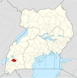
Buhweju District is a district in Western Uganda. It is one of the districts that constitute the Ankole sub-region. Its 'chief town', is Nsiika.
The Uganda National Roads Authority (UNRA) is a government agency mandated to develop and maintain the national roads network, advise the government on general roads policy, contribute to the addressing of national transport concerns, and perform certain other functions. UNRA is charged with, among other things, the selection of contractors, the supervision of construction, the scheduling of maintenance, and the prioritization of national road works.
The Acholibur–Gulu–Olwiyo Road is a road in the Northern Region of Uganda, connecting the town of Acholibur to the city of Gulu and the town of Olwiyo.
The Nyakahita–Kazo–Kamwenge–Fort Portal Road is a road in the Western Region of Uganda, connecting the towns of Nyakahita and Kazo in Kiruhura District, Ibanda in Ibanda District, Kamwenge in Kamwenge District, and Fort Portal in Kabarole District.
Nyakahita is a sparsely populated settlement in the Western Region of Uganda.
Kigumba–Masindi–Hoima–Kabwoya Road is a road in the Western Region of Uganda, connecting the towns of Kigumba in Kiryandongo District, Masindi in Masindi District, Hoima in Hoima District and Kabwoya, in Kikuube District.
The Musita–Mayuge–Lumino–Majanji–Busia Road is a road in the Eastern Region of Uganda, connecting the town of Musita in Mayuge District to Busia in Busia District at the international border with Kenya.
Musita is a town in Mayuge District, in the Eastern Region of Uganda.
Ziroobwe–Wobulenzi Road is a road in Central Uganda, connecting the towns of Ziroobwe to Bamunanika and Wobulenzi, all in Luweero District.
The Soroti–Dokolo–Lira Road is a road in Uganda, connecting the towns of Soroti in Soroti District, Dokolo in Dokolo District, and Lira in Lira District.
Muhanga is a town in the Western Region of Uganda. It is the main commercial centre and largest town of Rukiga District. However, the district headquarters are located at Mparo.
Ibanda University (IU) is a private, co-educational Ugandan university in the Western Region of Uganda.
