
Transportation in Botswana is provided by internal and extensive network of railways, highways, ferry services and air routes that criss-cross the country.

The Cuando River is a river in south-central Africa flowing through Angola and Namibia's Caprivi Strip and into the Linyanti Swamp on the northern border of Botswana. Below the swamp, the river is called the Linyanti River and, farther east, the Chobe River, before it flows into the Zambezi River.
Kazungula is a small border town in Zambia, lying on the north bank of the Zambezi River about 70 kilometres (45 mi) west of Livingstone on the M10 Road.

Kasane is a town in Botswana, close to Africa's 'Four Corners', where four countries almost meet: Botswana, Namibia, Zambia and Zimbabwe. It is at the far north-eastern corner of Botswana where it serves as the administrative center of the Chobe District. The population of Kasane was 9,008 in 2011 census.

Southern Province is one of Zambia's ten provinces, and home to Zambia's premier tourist attraction, Mosi-oa-Tunya, shared with Zimbabwe. The centre of the province, the Southern Plateau, has the largest area of commercial farmland of any Zambian province, and produces most of the maize crop.

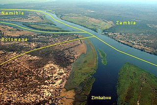
The Kazungula Ferry is a pontoon ferry across the 400-metre-wide (1,300 ft) Zambezi River between Botswana and Zambia. It is one of the largest ferries in south-central Africa, having a capacity of 70 tonnes. The service is provided by two motorised pontoons and operates between border posts at Kazungula, Zambia and Kazungula, Botswana.

The Lusaka–Livingstone Road or Livingstone Road is the main highway of the Southern Province of Zambia, from Lusaka city centre, to the principal tourist destination, Livingstone, Southern Africa, measuring approximately 485 kilometres (301 mi). The first 64 kilometres (40 mi), from Lusaka to Kafue Weighbridge, is part of the T2 Road and the remainder, from Kafue Weighbridge to Livingstone and continuing to the Victoria Falls is designated as the T1 Road. The entire route is part of Trans-African Highway network number 4 or Cairo–Cape Town Highway between Cairo and Cape Town.
List of Railway stations in Botswana include:

Railway stations in Zambia include:

Kazungula District is a district of Zambia, located in Southern Province. The capital lies at Kazungula. As of the 2000 Zambian Census, the district had a population of 68,265 people.

Botswana - People's Republic of China relations refers to the current and historical relationship between the Botswana and the People's Republic of China. Relations were first established on 6 January 1975. In 2010, upon the 35th anniversary of relations being formalized, the relationship between the two states was considered "strong" and "rapidly growing" by then Chinese ambassador to Botswana, Liu Huanxing. Botswana follows the One China Policy which means Botswana does not have relations with the Republic of China (Taiwan). Following the 2008 Sichuan earthquake in China, the Botswana government donated one million pula.

Kazungula is a village in the far north of Botswana, 8 km east of the town of Kasane. It lies on the south bank of the Chobe and Zambezi rivers.
Kazungula may refer to one of several adjacent places on the Zambezi River in central Africa:

Visitors to Zambia must obtain a visa from one of the Zambian diplomatic missions unless they come from one of the visa exempt countries or countries whose citizens are eligible for visa on arrival. Visitors may alternatively obtain an electronic visa. All visitors must hold a passport valid for at least 6 months. As of November 2014 Zambia and Zimbabwe also offer a universal visa.

Visitors to Zimbabwe must obtain a visa from one of the Zimbabwean diplomatic missions or online unless they come from one of the visa exempt countries or are eligible for visa on arrival. As of November 2014 Zimbabwe and Zambia also offer a universal tourist visa.

Kazungula Bridge is a road and rail bridge over the Zambezi river between the countries of Zambia and Botswana at Kazungula.
The A8 Highway is a paved primary trunk road in Zimbabwe running from Bulawayo to Victoria Falls. It is managed by the Zimbabwe National Roads Administration (ZINARA).
The M10 Road is a Road in Zambia. It goes from Livingstone, through Sesheke, to Mongu. The Road is approximately 508 kilometres and follows the Zambezi River for its entire length.
The Mosetse–Kazungula–Livingstone Railway is a prospected 430 kilometres (270 mi) cape gauge international railway connecting the Botswanan railway network at Mosetse, Botswana with the Zambian railway network at Livingstone, Zambia over the new Kazungula Bridge on the Zambezi River.
