
Transportation in Botswana is provided by an extensive network of railways, highways, ferry services and air routes that criss-cross the country. The transport sector in Botswana played an important role in economic growth following its independence in 1966. The country discovered natural resources which allowed it to finance the development of infrastructure, and policy ensured that the transport sector grew at an affordable pace commensurate with demands for services.

The Walvis Bay-Ndola-Lubumbashi Development Road runs from Walvis Bay, through Rundu in north eastern Namibia, along the Caprivi Strip to Katima Mulilo on the Zambezi River, which forms the border between Namibia and Zambia. The Katima Mulilo Bridge spans the river to the Zambian town of Sesheke from where a road runs to Livingstone, joining the main north–south highway to Lusaka, connecting onwards to the Copperbelt.
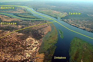
Kazungula is a small border town in Zambia, lying on the north bank of the Zambezi River about 70 kilometres (45 mi) west of Livingstone on the M10 Road.

Kasane is a town in Botswana, close to Africa's 'Four Corners', where four countries almost meet: Botswana, Namibia, Zambia and Zimbabwe. It is at the far north-eastern corner of Botswana where it serves as the administrative center of the Chobe District. The population of Kasane was 9,244 in 2011 census.

Southern Province is one of Zambia's ten provinces, and home to Zambia's premier tourist attraction, Mosi-oa-Tunya, shared with Zimbabwe. The centre of the province, the Southern Plateau, has the largest area of commercial farmland of any Zambian province, and produces most of the maize crop.

Kazungula is a small border post settlement in Matabeleland North, Zimbabwe close to Botswana, Namibia and Zambia. Just to the west is the Botswana border village of Kazungula, from where there is a bridge for vehicles across the Zambezi River to the town in Zambia also called Kazungula.

The Kazungula Ferry was a pontoon ferry across the 400-metre-wide (1,300 ft) Zambezi River between Botswana and Zambia. It was one of the largest ferries in south-central Africa, having a capacity of 70 tonnes. The service was provided by two motorised pontoons and operated between border posts at Kazungula, Zambia and Kazungula, Botswana.

Railway stations in Zambia include:

Kazungula District is a district of Zambia, located in Southern Province. The capital lies at Kazungula. As of the 2000 Zambian Census, the district had a population of 68,265 people.

Livingstone District is a district of Zambia, located in Southern Province. The capital lies at Livingstone, Zambia. As of the 2000 Zambian Census, the district had a population of 103,288 people. Its border with Zimbabwe is formed by the Zambezi River and Victoria Falls. Although most people live in Livingstone, other villages include Jinga Jinga in the north and Simonga in the southwest.

Kazungula is a village in the far north of Botswana, 8 km east of the town of Kasane. It lies on the south bank of the Chobe and Zambezi rivers.

Visitors to Zambia must obtain a visa from one of the Zambian diplomatic missions unless they come from one of the visa exempt countries or countries whose citizens are eligible for visa on arrival. Visitors may alternatively obtain an electronic visa. All visitors must hold a passport valid for at least 6 months. As of November 2014, Zambia and Zimbabwe also offer a universal visa.

Visitors to Zimbabwe must obtain a visa from one of the Zimbabwean diplomatic missions or online unless they come from one of the visa exempt countries or are eligible for visa on arrival. As of November 2014 Zimbabwe and Zambia also offer a universal tourist visa.
The A33 is a 363-kilometre-long (226 mi) road connecting Namibia and Zambia to the A3, to reach Francistown. Also, it connects people to, the otherwise remote, Kasane Airport. It goes from the Ngoma, Namibia Border Post eastwards to Kazungula and from Kazungula southwards to Nata, where it ends at a junction with the A3 road.

Kazungula Bridge is a road and rail bridge over the Zambezi River between the countries of Zambia and Botswana at the town of Kazungula. The 923-metre-long (3,028 ft) by 18.5-metre-wide (61 ft) bridge has a longest span of 129 metres (423 ft) and links the town of Kazungula in Zambia with Botswana. The bridge features a single-line railway track between two traffic lanes and walkways for pedestrians.
The M10 Road is a road in Zambia. It goes from Livingstone, through Sesheke and Senanga, to Mongu. The road is approximately 508 kilometres and follows the Zambezi River for its entire length.
The Mosetse–Kazungula–Livingstone Railway is a prospected 430 kilometres (270 mi) cape gauge international railway connecting the Botswana railway network at Mosetse, Botswana with the Zambian railway network at Livingstone, Zambia over the new Kazungula Bridge on the Zambezi River.
Katombola is a constituency of the National Assembly of Zambia. It covers Kazungula and surrounding areas in Kazungula District of Southern Province.