
Worcester is the 2nd most populous city in the U.S. state of Massachusetts and the 114th most populous city in the United States. Named after Worcester, England, the city's population was 206,518 at the 2020 census, also making it the second-most populous city in New England after Boston. Worcester is approximately 40 miles (64 km) west of Boston, 50 miles (80 km) east of Springfield and 40 miles (64 km) north-northwest of Providence. Due to its location near the geographic center of Massachusetts, Worcester is known as the "Heart of the Commonwealth"; a heart is the official symbol of the city. Worcester is the historical seat of Worcester County in central Massachusetts.

Millbury, officially the Town of Millbury, is a town in Worcester County, Massachusetts. Located within Blackstone Valley, the population in Millbury was 13,831 at the 2020 United States Census.

The Massachusetts Turnpike is a toll highway in the US state of Massachusetts that is maintained by the Massachusetts Department of Transportation (MassDOT). The turnpike begins at the New York state line in West Stockbridge, linking with the Berkshire Connector portion of the New York State Thruway. Spanning 138 miles (222 km) along an east–west axis, the turnpike constitutes the Massachusetts section of Interstate 90 (I-90). The turnpike is the longest Interstate Highway in Massachusetts, while I-90, in full, is the longest Interstate Highway in the United States.
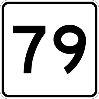
Route 79 is a 18.47-mile-long (29.72 km) state highway in southeastern Massachusetts. The route had formerly began as a highway in Fall River, also known as the Fall River Viaduct and Western Fall River Expressway, before becoming a more rural route further north. The southern expressway portion of the route was permanently closed by MassDOT in 2023 for conversion into a street level urban boulevard.

Interstate 495 (I-495) is an auxiliary route of I-95 in the US state of Massachusetts, maintained by the Massachusetts Department of Transportation (MassDOT). Spanning 121.56 miles (195.63 km), it is the second-longest auxiliary route in the Interstate Highway System, being roughly 11 miles (18 km) shorter than I-476 in Pennsylvania.

Route 2 is a 142.29-mile-long (228.99 km) major east–west state highway in Massachusetts, United States. Along with Route 9 and U.S. Route 20 to the south, these highways are the main alternatives to the Massachusetts Turnpike/I-90 toll highway. Route 2 runs the entire length of the northern tier of Massachusetts, beginning at the New York border, where it connects with New York State Route 2, and ending near Boston Common in Boston. Most of the route is an expressway through the northern tier of Massachusetts, with the longest surface road segments being the western portion. Older alignments of Route 2 are known as Route 2A.

Route 146 is a 20.99-mile (33.78 km) north-south expressway in the U.S. state of Massachusetts, maintained by the Massachusetts Department of Transportation (MassDOT). Spanning approximately 21 miles (34 km) along a south–north axis, it is a continuation of Route 146 in Rhode Island, which splits from I-95 in Providence. The southern terminus within Massachusetts exists in Millville, where the expressway enters the state from North Smithfield, Rhode Island. Among several local roads, Route 146 intersects with the Massachusetts Turnpike (I-90) in Millbury and I-290 in Worcester before arriving at its northern terminus at the intersection of several surface streets in downtown Worcester. Most of the route is a freeway, except for a short section near the boundary between Millbury and Sutton where there is driveway access and at-grade crossings.

Interstate 290 (I-290) is an auxiliary Interstate Highway in the US state of Massachusetts, maintained by the Massachusetts Department of Transportation (MassDOT). Spanning approximately 20 miles (32 km), it is signed as an east–west spur route of I-90 in Central Massachusetts. The route begins in Auburn at I-90 as a northward continuation of I-395. It follows an L-shaped route, the nominally western half of which runs north into the city of Worcester, and, upon leaving the city, turns to the east to its eastern terminus at I-495 in Marlborough. Past I-495, the road continues as an unnumbered one-mile (1.6 km) connector to the town of Hudson. The route serves as the main freeway route through Worcester, as well as being part of a longer distance travel corridor through New England, connecting Connecticut and Western Massachusetts with much of New Hampshire and Maine.
The Grand Junction Railroad is an 8.55-mile (13.76 km) long railroad in the Boston, Massachusetts, area, connecting the railroads heading west and north from Boston. The line is notable for its railroad bridge over the Charles River that passes under the Boston University Bridge between Boston and Cambridge, Massachusetts.

The Framingham/Worcester Line of the MBTA Commuter Rail system runs west from Boston, Massachusetts to Worcester, Massachusetts through the MetroWest region, serving 17 station stops in Boston, Newton, Wellesley, Natick, Framingham, Ashland, Southborough, Westborough, Grafton, and Worcester. It is the third longest and third busiest line in the MBTA Commuter Rail system. Service on the line is a mix of local and express trains serving Worcester plus short-turn Framingham locals.

Route 146 is a 16.24-mile (26.14 km) north-south expressway in the U.S. state of Rhode Island, maintained by the Rhode Island Department of Transportation (RIDOT). Spanning approximately 16 miles (26 km) along a northwest–southeast axis, it links the cities of Providence, Woonsocket, and Worcester, Massachusetts.

Route 140 is a 107.76-mile-long (173.42 km) north—south state highway which passes through Bristol, Norfolk and Worcester counties in Massachusetts. The highway follows a southeast-northwest trajectory, running from U.S. Route 6 in New Bedford just north of Buzzards Bay northwest to an intersection with Route 12 in Winchendon, a few miles south of the border with New Hampshire.
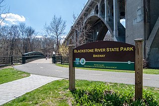
The Blackstone River Greenway is a partially completed 48-mile (77 km) paved rail trail defining the course of the East Coast Greenway through the Blackstone Valley from Worcester, Massachusetts to Providence, Rhode Island in the United States.

South Coast Rail is a project to build a new southern line of the MBTA Commuter Rail system along several abandoned and freight-only rail lines. The line has been planned to restore passenger rail service between Boston and the cities of Taunton, Fall River, and New Bedford, via the towns of Berkley, and Freetown, on the south coast of Massachusetts. It would restore passenger service to some of the southern lines of the former Old Colony Railroad and the New York, New Haven and Hartford Railroad.

Vaillancourt Folk Art (VFA) is the official Christmas Collectible Maker of the Commonwealth of Massachusetts and a business specializing in hand-painted chalkware collectables, based in Sutton, Massachusetts. Co-founder Judi Vaillancourt is credited with having developed the process used to create the first contemporary use of chalkware—incorporating a plaster-like substance with confectionery moulds—since the 20th century version.

Union Station is a railway station located at Washington Square in downtown Worcester, Massachusetts. It is the western terminus of the MBTA Commuter Rail Framingham/Worcester Line and a stop for the Amtrak Lake Shore Limited service. A bus terminal adjacent to the station is the hub for Worcester Regional Transit Authority (WRTA) local bus service; it is also used by PVTA, Peter Pan, Greyhound intercity buses.
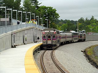
Wachusett station is a commuter rail station on the MBTA Commuter Rail Fitchburg Line. It is northwest of the intersection of Massachusetts Route 2 and Route 31 in Fitchburg, Massachusetts. It serves as the northwestern terminus for Fitchburg Line trains. The opening of Wachusett extended service 4.5 miles (7.2 km) west from Fitchburg on the Pan Am Southern main line, lengthening the Fitchburg Line to 54 miles (87 km). The station is expected to draw 400 daily riders.
The Table Talk Pie Company is an American pie company located in Worcester, Massachusetts.

Polar Park is a baseball park in Worcester, Massachusetts, serving as the home of the Worcester Red Sox, a Minor League Baseball team competing at the Triple-A level and an affiliate of the Boston Red Sox. Opened for the 2021 Triple-A season, it has a seating capacity of 9,508 people. Polar Beverages, a local beverage company based in Worcester, has retained the naming rights to the ballpark.

East-West Rail is a proposed passenger rail project that would provide new service between Boston and Western Massachusetts, with stops including Worcester, Palmer, Springfield, Chester, and Pittsfield. The 151-mile (243 km) route would use the former mainline of the Boston and Albany Railroad, which is now owned by the Massachusetts Bay Transit Authority and CSX Transportation.


