
Northamptonshire is a county in the East Midlands of England. In 2015, it had a population of 723,000. The county is administered by two unitary authorities: North Northamptonshire and West Northamptonshire. It is nicknamed "The Rose of the Shires".

Harborough is a local government district of Leicestershire, England, named after its main town, Market Harborough. Covering 230 square miles (600 km2), the district is by far the largest of the eight district authorities in Leicestershire and covers almost a quarter of the county. The district also covers the town of Lutterworth and villages of Broughton Astley and Ullesthorpe.
Arthingworth is a civil parish and village in the West Northamptonshire area of the county of Northamptonshire, England. The population of the civil parish at the 2011 census was 238.

Brixworth is a large village and civil parish in West Northamptonshire, England. The 2001 census recorded a parish population of 5,162, increasing to 5,228 at the 2011 census. The village's All Saints' Church is of Anglo-Saxon origin.

Kelmarsh is a village and civil parish in West Northamptonshire, England. The population of the civil parish at the 2011 Census was 208. The village is on the A508, close to its junction with the A14 about 5 miles (8 km) south of Market Harborough and 11 miles (18 km) north of Northampton.
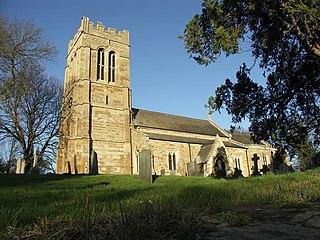
Great Oxendon is a linear village and civil parish in West Northamptonshire in England. At the time of the 2001 census, the parish's population was 307 people, increasing to 331 at the 2011 Census.

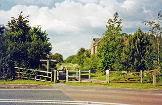
The Oxendon Tunnels are disused railway tunnels in Northamptonshire, England. The Northampton to Market Harborough line opened in 1859 and had tunnels at Oxendon and nearby at Kelmarsh.

The Brampton Valley Way is a 14-mile (23 km) rail trail built on the way of the former Northampton to Market Harborough Railway in Northamptonshire, England. It forms what trail managers, Northamptonshire County Council, describe as a linear park.

The Northampton loop is a railway line serving the town of Northampton. It is a branch of the West Coast Main Line, deviating from the faster direct main line which runs to the west. The WCML is a four track line up to either end of the Loop: the 'up' and 'down' fast tracks take the direct route while the 'up' and 'down' slow tracks are diverted via Northampton railway station. Generally, fast express trains run via the direct line, while freight and slower passenger services run via the loop line.

The Northampton and Lamport Railway is a standard gauge heritage railway in Northamptonshire, England. It is based at Pitsford and Brampton station, near the villages of Pitsford and Chapel Brampton, roughly 5 miles (8.0 km) north of Northampton.

The Midshires Way is a long-distance footpath and bridleway that runs for 230 miles (370 km) from the Chiltern Hills from near Bledlow in Buckinghamshire, through the Midlands counties of Northamptonshire, Leicestershire, Nottinghamshire and Derbyshire, to Stockport, Greater Manchester. It also links several other long-distance walking routes or trackways including The Ridgeway, the Pennine Bridleway and the Trans Pennine Trail.

The A508 is a short A-class road for north–south journeys in central and south central England, forming the route from Market Harborough in Leicestershire, via Northampton, to Old Stratford, just outside Milton Keynes.

Pitsford and Brampton railway station is a railway station serving the villages of Pitsford and Chapel Brampton in Northamptonshire, England.
National Cycle Route 6 is a route of the National Cycle Network, running from London to the Lake District.
Spratton railway station is a former railway station which served the village of Spratton in Northamptonshire, England.

The Northampton–Market Harborough line is a closed railway line in England. It opened on 16 February 1859 and finally closed on 16 August 1981. The former trackbed is used by the Brampton Valley Way and part of the route has been re-opened as the Northampton & Lamport Railway.
The Rugby and Stamford Railway was an early railway in England built in 1850. The London and Birmingham Railway had already built a branch from Blisworth to serve Northampton and extend to Peterborough. The success of this, the Northampton and Peterborough Railway encouraged the directors to look for other ventures. They decided upon a branch from Rugby to Stamford which would link up with other new railways in the east of the country.

Church Brampton was a railway station on the Northampton Loop Line serving the village of Church Brampton in Northamptonshire.
Lamport railway station on the Northampton and Market Harborough railway opened on 16 February 1859 serving the villages of Lamport, Maidwell, Hanging Houghton as well as Lamport Hall, Northamptonshire, England. It ran half a mile west of the village towards Maidwell just north of the road which was crossed by a level crossing. It was part of the London and North Western Railway. The next station north, Kelmarsh is located just north of Kelmarsh Tunnel.

Kelmarsh railway station on the Northampton and Market Harborough railway opened on 16 February 1859 serving the villages of Kelmarsh and Arthingworth, Northamptonshire, England. It ran almost equidistant between the two villages which are just under 2 miles (3.2 km) apart north-east of Kelmarsh and south-west of Arthingworth. It was part of the London and North Western Railway. The next station north, Clipston and Oxendon serving the villages of Great Oxendon and Clipston was situated south of Oxendon tunnel. To the south, Lamport was accessed via Kelmarsh tunnel.
