Kennedy Bridge, Bundaberg

Last updated

Kennedy Bridge
Kennedy Bridge, Bundaberg (2009).jpg
Kennedy Bridge, from Bundaberg Central side, 2009
LocationBourbong Street between Bundaberg Central & Bundaberg East, Bundaberg, Bundaberg Region, Queensland, Australia
Coordinates 24°51′49″S152°21′27″E / 24.8637°S 152.3575°E / -24.8637; 152.3575
Design period1870s–1890s (late 19th century)
Built1899
Architect Alfred Barton Brady
Architectural style(s) Classicism
Official nameKennedy Bridge, Saltwater Creek Road Bridge
Typestate heritage (built)
Designated21 October 1992
Reference no.600367
Significant period1890s (fabric)
Significant componentsfurniture/fittings, pylon/s
Australia Queensland location map.svg
Red pog.svg
Location of Kennedy Bridge in Queensland
Australia location map.svg
Red pog.svg
Kennedy Bridge, Bundaberg (Australia)

Kennedy Bridge is a heritage-listed road bridge on Bourbong Street crossing Bundaberg Creek from Bundaberg Central to Bundaberg East in Bundaberg, Bundaberg Region, Queensland, Australia. It was designed by Alfred Barton Brady and built in 1899. It is also known as Saltwater Creek Road Bridge. It was added to the Queensland Heritage Register on 21 October 1992. [1]

Contents

History

The Kennedy Bridge is a single span metal truss road bridge crossing Bundaberg Creek (also called Saltwater Creek), a tributary of the Burnett River, at Bundaberg. It was constructed in 1899 and was the smaller of two technically and visually related bridges designed by A.B. Brady for Bundaberg. [1]

The Burnett area was first settled by Europeans in the 1840s and 50s as a series of pastoral runs. In the late 1860s, as good agricultural land around Maryborough began to be scarce, agriculturalists and timbergetters became interested in land on the navigable Burnett River to the north. The foundation settlers of Bundaberg selected land in 1867-68 under the "Sugar and Coffee Regulations" stemming from the Crown Lands Alienation Act of 1860s which aimed to promote agriculture and closer settlement. The site of Bundaberg was officially surveyed in 1869. Coastal traffic grew, and copper was first mined at Mount Perry in 1871, which enabled Bundaberg to develop as a port and supply centre, in spite of competition from Maryborough for this trade. The provision of amenities was therefore of importance to the development of Bundaberg and this included bridges. [1]

Adam's Bridge, Bundaberg, 1878 StateLibQld 2 393149 Original Kennedy Bridge, Bundaberg, 1878.jpg
Adam's Bridge, Bundaberg, 1878

Although the higher southern bank of the Burnett River was officially surveyed as the town site, both sides developed and were initially linked only by ferry. Prior to 1872, the creek prevented the movement of vehicular traffic between the town of Bundaberg and the Woongarra Division to the east. Government action was urged in 1872 and money voted for the construction of a bridge. However, every tender exceeded the government estimate. The difficulty was solved when local property owner, Walter Adams, assisted the project by deliberately underbidding. A timber bridge, known as Adam's Bridge, was built and was the first in the district. [1]

Adam's Bridge was replaced by another timber bridge in 1878. [1] It was officially opened on Tuesday 26 March 1878 by the Queensland Governor, Arthur Kennedy, after whom the bridge was named. [2]

In the 1880s, Bundaberg boomed with the growth of the sugar industry in the region. Handsome and substantial masonry buildings began to rise in the city as evidence of its growing importance and prosperity. It was planned to replace the timber bridges, weakened by heavy traffic, by bridges not only stronger, but more in keeping the general upgrading of civic buildings. [1]

As a parallel project, two bridges of related design by A.B. Brady were constructed; the Burnett Bridge from Quay Street to Bundaberg North and this much smaller Kennedy Bridge across the Bundaberg Creek which opened in December 1899. It was funded under the Local Works Loan Act of 1880 and the Bundaberg Town Council and Woongarra Divisional Board bore two-thirds of its cost. It provided an example of co-operation between urban and rural local authorities for the advancement of the district in general. [1]

Kennedy Bridge at Bundaberg, circa 1911 Kennedy Bridge at Bundaberg Queensland, circa 1911.tiff
Kennedy Bridge at Bundaberg, circa 1911

The Kennedy Bridge is a reduced version of the Burnett Bridge which was opened on 24 August 1900. Both have similarities in structural design and appearance to the 1897 Victoria Bridge in Brisbane, which was demolished in the 1960s. All were designed by engineer and Government Architect, Alfred Barton Brady. [1]

A.B. Brady was born in 1856 and received his training in England. He became one of Queensland's most important early engineers and served the state in various departments for 37 years. He worked initially with the railways from 1885, then from 1889 with the Public Works Department, and then as Government Architect and engineer for bridges from 1892. Although Brady designed many important and handsome public buildings, his forte was bridge design and he designed a number of notable bridges. The Kennedy Bridge is interesting as an example of his work which is still in use and little altered. [1]

Description

Kennedy Bridge, 1939 Kennedy Bridge spannning Saltwater Creek in Bundaberg 1939.tiff
Kennedy Bridge, 1939

Kennedy Bridge joins Bourbong Street and Bourbong Street East over Saltwater Creek. It has a single metal truss span of 48.8 metres (160 ft) and metal lattice trusses with a curved upper chord. It carries a 7.3-metre (24 ft) roadway and a footpath. The metal deck spans between the lower chords of the trusses. [1]

Flanking the entrances to the bridge and rising above the trusses are L-shaped concrete pylons, square in appearance from the roadway. They are neo-classical in influence and have a Doric style entablature on a rusticated base. There are lights on decorative metal brackets facing the approaches. [1]

Repair work to the bridge was carried out in 1991 and it has since been repainted. It remains in very much its original form. [1]

Heritage listing

Kennedy Bridge was listed on the Queensland Heritage Register on 21 October 1992 having satisfied the following criteria. [1]

The place is important in demonstrating the evolution or pattern of Queensland's history.

Kennedy Bridge, opened in 1899, is important in illustrating the development and importance of Bundaberg in the late 19th and early 20th centuries as the centre of one of Queensland's most significant sugar-growing regions. [1]

The place is important in demonstrating the principal characteristics of a particular class of cultural places.

It is an important example of its type and is similar to, and closely associated with, the Burnett River Bridge, which was opened in 1900. [1]

The place has a special association with the life or work of a particular person, group or organisation of importance in Queensland's history.

It is important as a design of Alfred Barton Brady who, during 37 years of work for several departments of the Queensland government, made a major contribution to the development of the state in both architectural and engineering design. [1]

Related Research Articles

<span class="mw-page-title-main">Bundaberg</span> City in Queensland, Australia

Bundaberg is a city in the Bundaberg Region, Wide Bay, Queensland, Australia, and is the tenth largest city in the state. Bundaberg's urban area has a population of 73,747, and is a major centre of the Wide Bay–Burnett geographical region. The Bundaberg central business district is situated along the southern bank of the Burnett River, about 20 km (12 mi) from its mouth at Burnett Heads, and flows into the Coral Sea. The city is sited on a rich coastal plain, supporting one of the nation's most productive agricultural regions. The area of Bundaberg is the home of the Taribelang-Bunda, Goreng Goreng, Gurang, and Bailai peoples. Popular nicknames for Bundaberg include "Bundy", "Rum City", and "The 'Berg". The demonym of Bundaberg is Bundabergian.

<span class="mw-page-title-main">Lamington Bridge</span> Bridge in Queensland, Australia

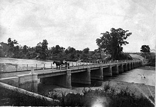
Lamington Bridge is a heritage-listed road bridge over the Mary River from Gympie Road, Tinana to Ferry Street, Maryborough, both in the Fraser Coast Region, Queensland, Australia. It was designed by Alfred Barton Brady and built from c. 1896 to 1970 by McArdle & Thompson. It was added to the Queensland Heritage Register on 21 October 1992.

<span class="mw-page-title-main">Bundaberg Central, Queensland</span> Suburb of Bundaberg, Queensland, Australia

Bundaberg Central is the central suburb and central business district of Bundaberg in the Bundaberg Region, Queensland, Australia. In the 2021 census, Bundaberg Central had a population of 162 people.

<span class="mw-page-title-main">Imbil Railway Bridge</span> Railway bridge over Yabba Creek in Queensland, Australia

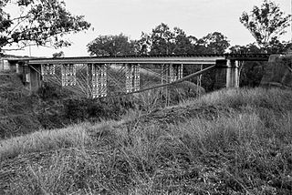
Imbil Railway Bridge is a heritage-listed railway bridge over Yabba Creek, Imbil, Gympie Region, Queensland, Australia. It was built circa 1915 by Queensland Railways to facilitate settlement in the Mary River Valley. It was added to the Queensland Heritage Register on 14 October 2011.

<span class="mw-page-title-main">Customs House, Maryborough</span> Historic site in Queensland, Australia

The Maryborough Customs House is a heritage-listed former customs house at Richmond Street, Maryborough, Fraser Coast Region, Queensland, Australia. It was designed by John Smith Murdoch and built in 1899. It was added to the Queensland Heritage Register on 7 February 2005.

<span class="mw-page-title-main">South Sea Islander Wall</span> Heritage plantation in Queensland, Australia

South Sea Islander Wall is a heritage-listed plantation at Grange Road, Mon Repos, Bundaberg Region, Queensland, Australia. It was built circa 1884 by South Sea Islander labour. It was added to the Queensland Heritage Register on 1 October 2001.

<span class="mw-page-title-main">Bundaberg Police Station</span> Historic site in Queensland, Australia

Bundaberg Police Station is a heritage-listed former court house (1882–1958) and former police station (1958–1997) at Quay Street, Bundaberg Central, Bundaberg, Bundaberg Region, Queensland, Australia. It was built from 1882 to 1958. It is also known as Bundaberg Court House. It was added to the Queensland Heritage Register on 1 December 1998.

<span class="mw-page-title-main">Burnett Bridge</span> Historic site in Queensland, Australia

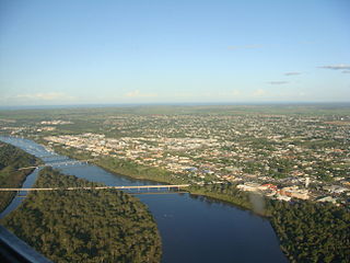
Burnett Bridge is a heritage-listed road bridge crossing the Burnett River from Quay Street, Bundaberg Central to Perry Street, Bundaberg North in Bundaberg, Bundaberg Region, Queensland, Australia. It was designed by Alfred Barton Brady and built in 1900. It is also known as Burnett River Traffic Bridge. It was added to the Queensland Heritage Register on 21 October 1992.

<span class="mw-page-title-main">Commercial Bank, Bundaberg</span> Historic site in Queensland, Australia

Commercial Bank of Sydney is a heritage-listed former bank building at 191–193 Bourbong Street, Bundaberg Central, Bundaberg, Bundaberg Region, Queensland, Australia. It was designed by George Allen Mansfield and built in 1891. It is also known as the National Australia Bank. It was added to the Queensland Heritage Register on 21 October 1992.

<span class="mw-page-title-main">East Bundaberg Water Tower</span> Historic site in Queensland, Australia

East Bundaberg Water Tower is a heritage-listed water tower at 17 Sussex Street, Bundaberg East, Bundaberg Region, Queensland, Australia. The tower is the only circular brick water-tower in Queensland and was designed by James Baillie Henderson and built from 1901 to 1902. It was added to the Queensland Heritage Register on 21 October 1992.

<span class="mw-page-title-main">Bundaberg East</span> Suburb of Bundaberg, Queensland, Australia

Bundaberg East is a suburb of Bundaberg in the Bundaberg Region, Queensland, Australia. In the 2016 census Bundaberg East had a population of 2,784 people.

<span class="mw-page-title-main">Alfred Barton Brady</span>

Alfred Barton Brady (1856-1932)was an engineer and architect in Queensland, Australia. He was one of Queensland's most important early engineers and was particularly known for his bridge design. He was the Queensland Colonial Architect and many of his buildings and structures are now heritage-listed.

<span class="mw-page-title-main">Saltwater Creek Railway Bridge</span> Historic site in Queensland, Australia

Saltwater Creek Railway Bridge is a heritage-listed railway bridge over Bundaberg Creek on Quay Street from Bundaberg Central to Bundaberg East in Bundaberg, Bundaberg Region, Queensland, Australia. It was built in 1894 by James Overend. It is also known as Millaquin Bridge. It was added to the Queensland Heritage Register on 21 October 1992.

<span class="mw-page-title-main">Sir Anthony's Rest</span> Historic site in Queensland, Australia

Sir Anthony's Rest is a heritage-listed dry-stone lookout at Sir Anthony's Rest Street, Qunaba, Bundaberg Region, Queensland, Australia. It was built for the official visit of the Governor of Queensland, Sir Anthony Musgrave, to Bundaberg in his 1888 tour of the area. It is located on the summit of the Bundaberg Hummock hill and provides a commanding view of the surrounding Bargara canefields.

<span class="mw-page-title-main">Gairloch Bridge</span> Historic site in Queensland, Australia

Gairloch Bridge is a heritage-listed road bridge over the Herbert River at Old Bruce Highway, Ingham, Shire of Hinchinbrook, Queensland, Australia. It was designed by Alfred Barton Brady and built from 1890 to 1891 by James Graham. It was added to the Queensland Heritage Register on 17 July 2008.

<span class="mw-page-title-main">Ideraway Creek Railway Bridge</span> Historic site in Queensland, Australia

Ideraway Creek Railway Bridge is a heritage-listed railway bridge at Mungar - Monto Line, Ideraway, North Burnett Region, Queensland, Australia. It was designed by William Pagan and built from 1906 to 1907 using day labour. It was added to the Queensland Heritage Register on 21 October 1992.

<span class="mw-page-title-main">Humphery Railway Bridge</span> Historic site in Queensland, Australia

Humphery Railway Bridge is a heritage-listed railway bridge on the Mungar to Monto railway line at Humphery, North Burnett Region, Queensland, Australia. It was designed by William Pagan and built in 1913. It was added to the Queensland Heritage Register on 21 October 1992.

<span class="mw-page-title-main">Bundaberg Central State School</span> Historic site in Queensland, Australia

Bundaberg Central State School is a heritage-listed state school at 13 Crofton Street, Bundaberg Central, Bundaberg, Bundaberg Region, Queensland, Australia. It was designed by Robert and John Ferguson and the Queensland Department of Public Works and built in 1890 by William Calvert. It is also known as Bundaberg South State School. It was added to the Queensland Heritage Register on 28 November 2014.

<span class="mw-page-title-main">Branyan Road State School</span> Historic site in Queensland, Australia

Branyan Road State School is a heritage-listed state school at Branyan Drive, Branyan, Bundaberg, Bundaberg Region, Queensland, Australia. It was designed by Queensland Department of Public Works and built in 1905. It was added to the Queensland Heritage Register on 1 May 2015.

Bundaberg–Bargara Road is a state-controlled district road in the Bundaberg region of Queensland, Australia. It is rated as a local road of regional significance (LRRS). It runs from the Isis Highway in Bundaberg West to Holland Street in Bargara, a distance of 14.4 kilometres (8.9 mi).

References

  1. 1 2 3 4 5 6 7 8 9 10 11 12 13 14 15 16 "Kennedy Bridge (entry 600367)". Queensland Heritage Register . Queensland Heritage Council. Retrieved 1 August 2014.
  2. "The Governor's Visit to Bundaberg". The Brisbane Courier . 30 March 1878. p. 5. Retrieved 14 November 2015 via National Library of Australia.

Attribution

CC-BY-icon-80x15.png This Wikipedia article was originally based on "The Queensland heritage register" published by the State of Queensland under CC-BY 3.0 AU licence (accessed on 7 July 2014, archived on 8 October 2014). The geo-coordinates were originally computed from the "Queensland heritage register boundaries" published by the State of Queensland under CC-BY 3.0 AU licence (accessed on 5 September 2014, archived on 15 October 2014).

Commons-logo.svg Media related to Kennedy Bridge, Bundaberg at Wikimedia Commons