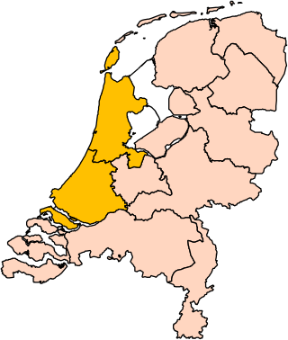
Holland is a geographical region and former province on the western coast of the Netherlands. From the 10th to the 16th century, Holland proper was a unified political region within the Holy Roman Empire as a county ruled by the counts of Holland. By the 17th century, the province of Holland had risen to become a maritime and economic power, dominating the other provinces of the newly independent Dutch Republic.

Haarlem is a city and municipality in the Netherlands. It is the capital of the province of North Holland. Haarlem is situated at the northern edge of the Randstad, one of the more populated metropolitan areas in Europe; it is also part of the Amsterdam metropolitan area. Haarlem had a population of 162,543 in 2021.

Bloemendaal is a municipality and a town in the Netherlands, in the province of North Holland. Bloemendaal is, together with Wassenaar, the wealthiest place in the Netherlands.

Hillegom is a town and municipality in the Western Netherlands, in the province of South Holland. Hillegom is part of an area called the Duin- en Bollenstreek. As such, a large portion of the local economy was traditionally geared to the cultivation of bulb flowers.

East Frisia or East Friesland is a historic region in the northwest of Lower Saxony, Germany. It is primarily located on the western half of the East Frisian peninsula, to the east of West Frisia and to the west of Landkreis Friesland.

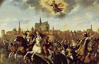
Floris V reigned as Count of Holland and Zeeland from 1256 until 1296. His life was documented in detail in the Rijmkroniek by Melis Stoke, his chronicler. He is credited with a mostly peaceful reign, modernizing administration, policies beneficial to trade, generally acting in the interests of his peasants at the expense of nobility, and reclaiming land from the sea. His dramatic murder, engineered by King Edward I of England and Guy, Count of Flanders, made him a hero in Holland.

The counts of Holland ruled over the County of Holland in the Low Countries between the 10th and the 16th century.

The County of Holland was a state of the Holy Roman Empire and from 1433 part of the Burgundian Netherlands, from 1482 part of the Habsburg Netherlands and from 1581 onward the leading province of the Dutch Republic, of which it remained a part until the Batavian Revolution in 1795. The territory of the County of Holland corresponds roughly with the current provinces of North Holland and South Holland in the Netherlands.

Dirk V was Count of Holland from 1061 to 1091.
Dirk VI was Count of Holland between 1121 and 1157, at first, during his minority, under the regency of his mother Petronilla. He was the son of Count Floris II. After his death he was succeeded by his eldest son Floris III. He married Sofie of Salm, Countess of Rheineck and Bentheim. She was heiress of Bentheim, which she ruled together with her husband and which was inherited by the couple's second son Otto after his parents' death.
Dirk III was the count with jurisdiction over what would become the county of Holland, often referred to in this period as "West Frisia", from 993 to 27 May 1039. Until 1005, this was under regency of his mother. It is thought that Dirk III went on pilgrimage to the Holy Land around 1030, hence his nickname of Hierosolymita.

The Battle of Warns was a battle of the Friso-Hollandic Wars between Count William IV of Holland and the Frisians which took place on 26 September 1345. The annual commemoration of the battle is important for many nationalist Frisians. The Frisians won the battle and repelled the 'Hollanders' from the eastern coast of the Zuiderzee.

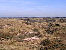
Zuid-Kennemerland National Park is a conservation area on the west coast of the province of North Holland. It was established in 1995.

Flower bulb cultivation is an economic activity in the provinces of North Holland, South Holland and Flevoland. The colourful flower fields that have come to symbolise Holland can be seen in these areas around April.

Frisian freedom was the absence of feudalism and serfdom in Frisia, the area that was originally inhabited by the Frisians. Historical Frisia included the modern provinces of Friesland and Groningen, and the area of West Friesland, in the Netherlands, and East Friesland in Germany. During the period of Frisian freedom the area did not have a sovereign lord who owned and administered the land. The freedom of the Frisians developed in the context of ongoing disputes over the rights of local nobility.

The Frisian Kingdom, also known as Magna Frisia, is a modern name for the post-Roman Frisian realm in Western Europe in the period when it was at its largest (650–734). This dominion was ruled by kings and emerged in the mid-7th century and probably ended with the Battle of the Boarn in 734 when the Frisians were defeated by the Frankish Empire. It lay mainly in what is now the Netherlands and – according to some 19th century authors – extended from the Zwin near Bruges in Belgium to the Weser in Germany. The center of power was the city of Utrecht.
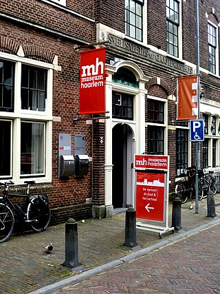
Museum Haarlem is a city museum on Groot Heiligland 47, Haarlem, Netherlands, located across the street from the Frans Hals Museum. It shares its front door with the ABC Architectuurcentrum Haarlem, which is located next door. The museum is devoted to presenting and preserving the cultural history of Haarlem and the surrounding region.
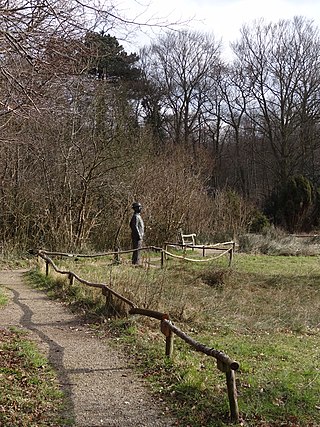
Thijsse's Hof is a wildlife garden in Bloemendaal, the Netherlands. It was created in 1925 on the occasion of the 60th birthday of Jac. P. Thijsse, naturalist and nature conservationist. It is the oldest wildlife garden in the Netherlands, and one of the oldest of Europe, and in the world.
The Kennemer uprising was a rebellion of farmers in the County of Holland and Prince-Bishopric of Utrecht in the Holy Roman Empire, that took place between 1272 and 1274. The commoners or huislieden from the Kennemerland, a bailiwick within the County of Holland, rose up against their bailiff and the other nobles. The movement spread to the nearby West Friesland, Waterland and Amstelland. The lord of Amstelland, Gijsbrecht IV of Amstel decided to join the insurrenction and became the leader of the Kennemers. Later Utrecht, Amersfoort and Eemland also joined. Eventually, the Kennemers were defeated.
The Battle of Heiloo was a battle during the Friso-Hollandic Wars and the culmination of Count Floris V's first military expedition to West Frisia in 1272. The battle is described in Melis Stoke's Rijmkroniek van Holland and the chronicle of Johannes de Beke. Although the battle was won by Floris' forces, his goal of conquering West Frisia had not been achieved, and the count retreated shortly after.