
Bell County is a county located in the southeast part of the U.S. state of Kentucky. As of the 2020 census, the population was 24,097. Its county seat is Pineville and its largest city is Middlesboro. The county was formed in 1867, during the Reconstruction era from parts of Knox and Harlan counties and augmented from Knox County in 1872. The county is named for Joshua Fry Bell, a US Representative. It was originally called "Josh Bell", but on January 31, 1873, the Kentucky legislature shortened the name to "Bell",
Middlesboro is a home rule-class city in Bell County, Kentucky, United States. The population was 10,334 at the 2010 U.S. census, while its micropolitan area had a population of 69,060.

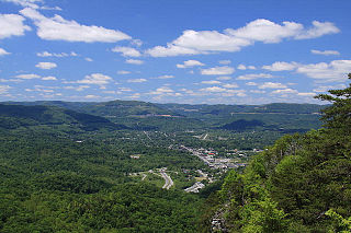
Pineville is a home rule-class city in Bell County, Kentucky, United States. It is the seat of its county. The population was 1,732 as of the 2010 census. It is located on a small strip of land between the Cumberland River and Pine Mountain.

U.S. Route 25 or U.S. Highway 25 (US 25) is a north–south United States Numbered Highway that runs for 750 miles (1,210 km) in the Southern and Midwestern U.S. Its southern terminus is in Brunswick, Georgia, from where it proceeds mostly due north, passing through the cities of Augusta, Georgia; Greenville, South Carolina; and Asheville, North Carolina, before dividing into two branches, known as US 25W and US 25E between Newport, Tennessee, and North Corbin, Kentucky. After passing through Richmond and Lexington, Kentucky, it reaches its northern terminus at Ohio state line in Covington, Kentucky. The route is an important crossing of the Appalachian Mountains, and it is covered by three of the corridors of the Appalachian Development Highway System (ADHS). When the highway was originally established in 1926, the route extended from North Augusta, South Carolina, to Port Huron, Michigan. The southern end was extended to its current terminus in 1936, while the northern end was truncated in 1974.

U.S. Route 58 is an east–west U.S. Highway that runs for 508 miles (818 km) from U.S. Route 25E just northwest of Harrogate, Tennessee, to U.S. Route 60 in Virginia Beach, Virginia. Until 1996, when the Cumberland Gap Tunnel opened, US 58 ran only inside the commonwealth of Virginia. It was then extended southwest along a short piece of former US 25E, which no longer enters Virginia, to end at the new alignment in Tennessee. For most of its alignment, it closely parallels Virginia's southern border with North Carolina.

The Cumberland Gap Tunnel is a dual-bore, four lane vehicular tunnel that carries U.S. Route 25E under Cumberland Gap National Historical Park near the intersection of Kentucky, Tennessee, and Virginia. The tunnel consists of two separate bores which carry four lanes of traffic between Cumberland Gap, Tennessee and Middlesboro, Kentucky. It is one of only two mountain vehicular tunnels in the United States that cross a state line, the other being the East River Mountain Tunnel on Interstate 77 and U.S. Route 52 between Virginia and West Virginia. The tunnel opened to traffic in 1996 and replaced a section of highway through the Cumberland Gap that had earned the nickname "Massacre Mountain" due to its hazardous design and high rate of traffic accidents.

U.S. Route 31E (US 31E) is the eastern parallel route for U.S. Highway 31 from Nashville, Tennessee, to Louisville, Kentucky.

U.S. Route 25E (US 25E) is the eastern branch of US 25 from Newport, Tennessee, where US 25 splits into US 25E and US 25W, to North Corbin, Kentucky, where the two highways rejoin. The highway, however, continues as US 25E for roughly two miles (3.2 km) until it joins Interstate 75 (I-75) in the Laurel County community of North Corbin at exit 29. The highway serves the Appalachia regions of Kentucky's Cumberland Plateau and the Ridge-and-Valley section of East Tennessee, including the urbanized areas of Corbin and Middlesboro in Kentucky and Morristown in Tennessee.

U.S. Route 25W (US 25W) is the western branch of US 25 from Newport, Tennessee, where US 25 splits into US 25E and US 25W, to North Corbin, Kentucky, where the two highways rejoin.
U.S. Route 25 (US 25) runs for 176.882 miles (284.664 km) across the state of Kentucky from the split between US 25E and US 25W in North Corbin to US 42/US 127 at the Ohio state line in Covington.

Kentucky Route 92 (KY 92) is a 112.485-mile-long (181.027 km) state highway Kentucky. The route is split into two segments by Lake Cumberland and is one of a few state routes in Kentucky with two discontinuous segments on both sides of a body of water. The western segment, which is 17.221-mile-long (27.715 km), runs from Kentucky Route 55 west of Joppa to a dead end on Lake Cumberland south of Jamestown via Joppa, Montpelier, Esto, and Jamestown. The eastern segment, which is 95.264-mile-long (153.313 km), runs from a boat ramp on Lake Cumberland northwest of Monticello to U.S. Route 25E west of Fourmile via Monticello, Barrier, Stearns, Carpenter, Timsley, and Ingram.

State Route 33 is a primary and secondary route in East Tennessee. It runs 176 miles, from the Georgia state line in Polk County, northeast to the Virginia state line north of Kyles Ford in Hancock County. South of Maryville, SR 33 is a "hidden" route which shares a concurrency with US 411.

State Route 63 is an east–west state highway in the northern portion of eastern Tennessee. It goes from U.S. Route 27 in Huntsville to SR 33 in Sneedville, running 102 miles (164 km).

State Route 32 is a state highway in East Tennessee. For most of its route, it is an unsigned companion route concurrent with U.S. Route 25E. The highway stretches 89 miles from the North Carolina state line to the Tennessee-Kentucky state line near the town of Cumberland Gap.

State Route 343 is a state highway in Morristown, Hamblen County in the U.S. state of Tennessee. It serves as connector from US 25E into downtown Morristown.

State Route 90 is a 13.5-mile-long (21.7 km) state highway in Campbell and Claiborne counties in the U.S. state of Tennessee. It serves the communities of Morley, White Oak, Eagan and Clairfield in Tennessee, and Pruden at the Tennessee-Kentucky state line.

Kentucky Route 190 (KY 190) is a 21.5-mile-long (34.6 km) state highway in the U.S. state of Kentucky. The highway travels through rural areas of Bell County.

Kentucky Route 186 (KY 186) is a 3.0-mile-long (4.8 km) state highway in the U.S. state of Kentucky. The highway connects mostly rural areas of Bell County with Middlesboro.

Kentucky Route 441 (KY 441) is a 4.897-mile-long (7.881 km) state highway in the U.S. state of Kentucky. The highway travels through mostly urban areas of Bell County. Virtually the entire highway is within the city limits of Middlesboro.

Kentucky Route 3041 (KY 3041) is a state highway in the southeastern part of the U.S. state of Kentucky. Known as the Corbin Bypass, the route runs 5.700 miles (9.173 km) from U.S. Route 25W east and north to US 25E within Corbin. KY 3041 provides a southeastern bypass of the center of Corbin through eastern Whitley County and western Knox County. The bypass was planned starting in the late 1980s and was constructed in three stages in the mid-1990s. KY 3041 eased congestion in downtown Corbin and stimulated educational and industrial development in the late 1990s.

