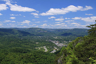
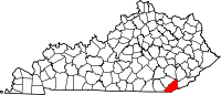
Pineville is a home rule-class city in Bell County, Kentucky, United States. It is the seat of its county. The population was 1,732 as of the 2010 census. It is located on a small strip of land between the Cumberland River and Pine Mountain.
Kentucky Route 92 (KY 92) is a 112.485-mile-long (181.027 km) state highway Kentucky. The route is split into two segments by Lake Cumberland, one of a few state routes in Kentucky with two discontinued segments on both sides of a body of water. The western segment, which is 17.221-mile-long (27.715 km), runs from Kentucky Route 55 west of Joppa to a dead end on Lake Cumberland south of Jamestown via Joppa, Montpelier, Esto, and Jamestown. The eastern segment, which is 95.264-mile-long (153.313 km), runs from a boat ramp on Lake Cumberland northwest of Monticello to U.S. Route 25E west of Fourmile via Monticello, Barrier, Stearns, Carpenter, Timsley, and Ingram.
Kentucky Route 66 is a 46.59 mile (74.98 km) long state highway in southeastern Kentucky. The route runs from Oneida in Clay County to Pineville in Bell County.

The Middlesborough, KY Micropolitan Statistical Area is a United States Census Bureau defined Micropolitan Statistical Area located in the vicinity of Middlesboro, Kentucky. The Middlesborough Micropolitan Statistical Area encompasses Bell County entirely. The Micropolitan Statistical Area had a population of 30,060 at the 2000 Census. A July 1, 2009 U.S. Census Bureau estimate placed the population at 69,060.

Black Snake is an unincorporated community located in Bell County, Kentucky, United States.
Mocking Bird Branch was an unincorporated community located in Bell County, Kentucky, United States.
Harbell is an unincorporated community located in Bell County, Kentucky, United States.
Olcott is an unincorporated community located in Bell County, Kentucky, United States.
Ponza is an unincorporated community located in Bell County, Kentucky, United States.
Rella is an unincorporated community located in Bell County, Kentucky, United States.
Meldrum is an unincorporated community located in Bell County, Kentucky, United States.
Oaks is an unincorporated community located in Bell County, Kentucky, United States.
Premier is an unincorporated community located in Bell County, Kentucky, United States.

Pruden is an unincorporated community located partly in Bell County, Kentucky and partly in Claiborne County, Tennessee, in the southeastern United States. It is located along Tennessee State Route 90 and Kentucky Route 74, which intersect at the state line, in the upper Clearfork Valley. Pruden had a post office on the Tennessee side of the border from September 20, 1906, to May 21, 2011; it still has its own ZIP code, 37851.
Kettle Island is an unincorporated community and coal town in Bell County, Kentucky, United States. Kettle Island is located on Kentucky Route 1630 near Kentucky Route 221, 5.35 miles (8.61 km) east-northeast of Pineville. Kettle Island has a post office with ZIP code 40958, which opened on March 15, 1912. The community also had a station on the Louisville and Nashville Railroad.

Arjay is an unincorporated community and coal town in Bell County, Kentucky, United States. Arjay is located on Kentucky Route 66 4 miles (6.4 km) northeast of Pineville. Arjay has a post office with ZIP code 40902, which opened on February 23, 1911. The community's name comes from the initials of coal operator R. J. Asher.
Stoney Fork is an unincorporated community in Bell County, Kentucky, United States. Stoney Fork is located on Kentucky Route 221 10.1 miles (16.3 km) east-northeast of Pineville. Stoney Fork has a post office with ZIP code 40988, which opened on November 20, 1946.
Ingram is an unincorporated community in Bell County, Kentucky, United States. Ingram is located on Kentucky Route 92 6.2 miles (10.0 km) west-southwest of Pineville. Ingram has a post office with ZIP code 40955, which opened on July 15, 1881.