Breathitt County is a county located in the eastern Appalachian portion of the U.S. state of Kentucky. As of the 2010 census, the population was 13,878. Its county seat is Jackson, Kentucky. The county was formed in 1839 and was named for John Breathitt, who was Governor of Kentucky from 1832 to 1834. Breathitt County was a prohibition or dry county, until a public vote in July 2016 that allowed alcohol sales.

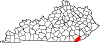
Bell County is a county located in the southeast part of the U.S. state of Kentucky. As of the 2010 census, the population was 28,691. Its county seat is Pineville. The county was formed in 1867, during the Reconstruction era from parts of Knox and Harlan counties and augmented from Knox County in 1872. The county is named for Joshua Fry Bell, a US Representative. It was originally called "Josh Bell", but on January 31, 1873, the Kentucky legislature shortened the name to "Bell",
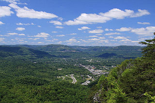
Middlesboro is a home rule-class city in Bell County, Kentucky, United States. The population was 10,334 at the 2010 U.S. census, while its micropolitan area had a population of 69,060.

Pineville is a home rule-class city in Bell County, Kentucky, United States. It is the seat of its county. The population was 1,732 as of the 2010 census. It is located on a small strip of land between the Cumberland River and Pine Mountain.

Independence is a home rule-class city in Kenton County, Kentucky, in the United States. It is one of its county's two seats of government. The population was 24,757 at the time of the 2010 U.S. census, up from 14,982 at the 2000 census.

The Louisville and Nashville Railroad, commonly called the L&N, was a Class I railroad that operated freight and passenger services in the southeast United States.
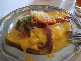
The cuisine of Kentucky mostly resembles that of traditional Southern cuisine. Some common dinner dishes are fried catfish and hushpuppies, fried chicken and country fried steak. These are usually served with vegetables such as green beans, greens, pinto beans slow-cooked with pork as seasoning and served with cornbread. Other popular items include fried green tomatoes, cheese grits, corn pudding, fried okra, and chicken and dumplings, which can be found across the commonwealth. In addition to this, Kentucky is known for its own regional style of barbecue. This style of barbecue is unique in itself given that it uses mutton, and is a style of Southern barbecue unique to Kentucky. Although Kentucky's cuisine is generally very similar to that of traditional Southern cuisine, it does differ with some unique dishes, especially in Louisville where the Hot Brown and Derby pie, originated.

This is a list of properties and historic districts in Kentucky that are listed on the National Register of Historic Places. There are listings in all of Kentucky's 120 counties.
Grindstone is a Thoroughbred racehorse, best known for winning the 1996 Kentucky Derby.
The Red Bird River is a tributary of the South Fork Kentucky River, located in the Daniel Boone National Forest in extreme southeastern portion of the U.S. state of Kentucky. It is 34.3 miles (55.2 km) long and drains an area of 195.7 square miles (507 km2).

The Kentucky Coal Museum is heritage center located in Benham, Kentucky. Its focus is the history of the coal industry in Eastern Kentucky, featuring specific exhibits on the company towns of Benham and neighboring Lynch. It is housed in a former company store that was built by International Harvester in 1923. In June 1990, the Tri-City Chamber of Commerce purchased the building for the future site of the museum. After receiving additional grants from the state of Kentucky, the museum opened in May 1994.

Beverly is an unincorporated community in Bell County, Kentucky, United States. It was also known as Nuckles and Red Bird which was a coal town. Its post office is closed.
Kentucky Route 190 (KY 190) is a 21.5-mile-long (34.6 km) state highway in the U.S. state of Kentucky. The highway travels through rural areas of Bell County.
Kentucky Route 221 (KY 221) is a 42.5-mile-long (68.4 km) state highway in the U.S. state of Kentucky. The highway connects mostly rural areas of Bell, Harlan, Perry, and Leslie counties with the Daniel Boone National Forest.
Kentucky Route 225 (KY 225) is a 16.4-mile-long (26.4 km) state highway in the U.S. state of Kentucky. The highway connects mostly rural areas of Bell and Knox counties with Barbourville.
Kentucky Route 377 (KY 377) is a 23.894-mile-long (38.454 km) state highway in the U.S. state of Kentucky. The highway connects mostly rural areas of Rowan and Lewis counties with the Morehead area.
Kentucky Route 441 (KY 441) is a 4.897-mile-long (7.881 km) state highway in the U.S. state of Kentucky. The highway travels through mostly urban areas of Bell County. Virtually the entire highway is within the city limits of Middlesboro.