Bourbon is a type of barrel-aged American whiskey made primarily from corn (maize). The name derives from the French Bourbon dynasty, although the precise source of inspiration is uncertain; contenders include Bourbon County in Kentucky and Bourbon Street in New Orleans, both of which are named after the dynasty. The name bourbon was not applied until the 1850s, and the Kentucky etymology was not advanced until the 1870s.

The Kentucky Oaks is a Grade I stakes race for three-year-old Thoroughbred fillies staged annually in Louisville, Kentucky, United States. The race currently covers 1+1⁄8 miles (1,800 m) at Churchill Downs; the horses carry 121 pounds (55 kg). The Kentucky Oaks is held on the Friday before the Kentucky Derby each year. The winner gets $750,000 of the $1,250,000 purse, and a large garland blanket of lilies, resulting in the nickname "Lillies for the Fillies." A silver Kentucky Oaks Trophy is presented to the winner.

Todd County is a county located in the U.S. state of Kentucky. As of the 2020 census, the population was 12,243. Its county seat is Elkton. The county is named for Colonel John Todd, who was killed at the Battle of Blue Licks in 1782 during the American Revolution.

Christian County is a county located in the U.S. state of Kentucky. As of the 2020 census, the population was 72,748. Its county seat is Hopkinsville. The county was formed in 1797. Christian County is part of the Clarksville, TN–KY Metropolitan Statistical Area.

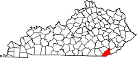
Bell County is a county located in the southeast part of the U.S. state of Kentucky. As of the 2020 census, the population was 24,097. Its county seat is Pineville and its largest city is Middlesboro. The county was formed in 1867, during the Reconstruction era from parts of Knox and Harlan counties and augmented from Knox County in 1872. The county is named for Joshua Fry Bell, a US Representative. It was originally called "Josh Bell", but on January 31, 1873, the Kentucky legislature shortened the name to "Bell",

Pineville is a home rule-class city in Bell County, Kentucky, United States. It is the seat of its county. The population was 1,732 as of the 2010 census. It is located on a small strip of land between the Cumberland River and Pine Mountain.
Hopkinsville is a home rule-class city in and the county seat of Christian County, Kentucky, United States. The population at the 2020 census was 31,180.

Oak Grove is a home rule-class city adjacent to the Fort Campbell army base in Christian County, Kentucky, in the United States. The population was 7,489 as of the 2010 U.S. Census. It is part of the Clarksville, Tennessee metropolitan area.
Red oaks are tree species in the genus Quercussection Lobatae.

The Cumberland Plateau is the southern part of the Appalachian Plateau in the Appalachian Mountains of the United States. It includes much of eastern Kentucky and Tennessee, and portions of northern Alabama and northwest Georgia. The terms "Allegheny Plateau" and the "Cumberland Plateau" both refer to the dissected plateau lands lying west of the main Appalachian Mountains. The terms stem from historical usage rather than geological difference, so there is no strict dividing line between the two. Two major rivers share the names of the plateaus, with the Allegheny River rising in the Allegheny Plateau and the Cumberland River rising in the Cumberland Plateau in Harlan County, Kentucky.

The Clarksville Metropolitan Statistical Area is defined by the United States Census Bureau as an area consisting of four counties – two in Tennessee and two in Kentucky – anchored by the city of Clarksville, Tennessee. The 2021 estimate placed the population at 329,864. As of 2020, the Clarksville Metropolitan Statistical Area is the 159th largest MSA in the United States.

This is a list of properties and historic districts in Kentucky that are listed on the National Register of Historic Places. There are listings in all of Kentucky's 120 counties.

This is a list of the National Register of Historic Places listings in Bell County, Kentucky.
Red Oak is an unincorporated community located in Bell County, Kentucky, United States.