
Switzerland has a dense network of roads and railways. The Swiss public transport network has a total length of 24,500 kilometres and has more than 2600 stations and stops.
The A3, known as the Portsmouth Road or London Road in sections, is a major road connecting the City of London and Portsmouth passing close to Kingston upon Thames, Guildford, Haslemere and Petersfield. For much of its 67-mile (108 km) length, it is classified as a trunk road and therefore managed by National Highways. Almost all of the road has been built to dual carriageway standards or wider. Apart from bypass sections in London, the road travels in a southwest direction and, after Liss, south-southwest.

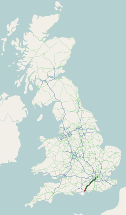
The A303 is a trunk road in southern England, running between Basingstoke in Hampshire and Honiton in Devon via Stonehenge. Connecting the M3 and the A30, it is part of one of the main routes from London to Devon and Cornwall. It is a primary A road throughout its length, passing through five counties.

The A40 is a trunk road which runs between London and Goodwick (Fishguard), Wales, and officially called The London to Fishguard Trunk Road (A40) in all legal documents and Acts. Much of its length within England has been superseded by motorways, such as the M40, and has lost its trunk road status, though it retains it west of Gloucester, including its length within Wales. It is approximately 260 miles (420 km) long. The eastern section from Denham, Buckinghamshire to Wheatley, Oxfordshire is better served by the M40 and its former function of linking London with Cheltenham and Gloucester has been taken by the M4, A419 and A417 via Swindon.

The M67 is a 5-mile-long (8 km) urban motorway in Greater Manchester, England, which heads east from the M60 motorway passing through Denton and Hyde before ending near Mottram. The road was originally conceived as the first section of a trans-Pennine motorway between Manchester and Sheffield that would connect the A57(M) motorway with the M1 motorway; however, the motorway became the only part to be built.

The A55, also known as the North Wales Expressway, is a major road in Wales and England, connecting Cheshire and North Wales. The vast majority of its length from Chester to Holyhead is a dual carriageway primary route, with the exception of the Britannia Bridge over the Menai Strait and several short sections where there are gaps in between the two carriageways. All junctions are grade separated apart from a roundabout east of Penmaenmawr and another nearby in Llanfairfechan. Initially, the road ran from Chester to Bangor. In 2001, it was extended across Anglesey to the ferry port of Holyhead parallel to the A5. The road improvements have been part funded with European money, under the Trans-European Networks programme, as the route is designated part of Euroroute E22.

National Development Plan is the title given by the Irish Government to a scheme of organised large-scale expenditure on (mainly) national infrastructure. The first five-year plan ran from 1988 to 1993, the second was a six-year plan from 1994 to 1999 and the third ran as a seven-year plan from 2000 to 2006. A fourth National Development Plan ran from 2007 to 2011. The main elements of the third plan were the development of a national motorway network between the major cities in Ireland. The upgrading of the rail network was a secondary scheme.

The N4 road is a national primary road in Ireland, running from Dublin to the northwest of Ireland and Sligo town. The M6 to Galway diverges from this route after Kinnegad, while the N5 to Westport diverges at Longford town. Most sections of the N4 that are motorway-standard are designated the M4 motorway.

A dual carriageway (BrE) or a divided highway (AmE) is a class of highway with carriageways for traffic travelling in opposite directions separated by a central reservation (BrE) or median (AmE). Roads with two or more carriageways which are designed to higher standards with controlled access are generally classed as motorways, freeways, etc., rather than dual carriageways.

The A3 is a motorway in northeast Switzerland, running diagonally from France toward the southeast border, and passing by Zürich on the way. The total length of the A3 motorway spans roughly 180 kilometres (110 mi), but parts of the road share sections of the A1 and A2 motorways.

The N18 road is a national primary road in Ireland, connecting the cities of Limerick and Galway. Ennis and Gort are two major towns on the route, and Shannon Airport is reached via the connecting N19. The west coast route continues on to Sligo as the N17. The section from Limerick to the N19 junction forms part of European route E20, and the entire route is part of the proposed Atlantic Corridor. The section of motorway from Shannon to Claregalway is designated the M18 motorway. The tolled Limerick Tunnel forms part of the route.

Filzbach is a former municipality in the canton of Glarus in Switzerland. Effective from 1 January 2011, Filzbach is part of the municipality of Glarus Nord.

The A505 is a road in the East of England. It follows part of the route of the Icknield Way and the corresponding Icknield Way Path and runs from Leighton Buzzard in Bedfordshire to the A11 Abington Interchange North in Cambridgeshire.

The design of road signs in Poland is regulated by Regulation of the Ministers of Infrastructure and Interior Affairs and Administration on road signs and signals. The Annex 1 to the regulation describes conditions related to usage of the road signs – size, visibility, colors and light reflections, typeface and text, criteria of choosing the type of foil to signs faces, colorful specimens and schematics.
NH 248-BB, commonly known as Dwarka Expressway is a 27.6 km (17.1 mi) long, under construction, 8-lane (elevated) and 8-lane, total 16-lane elevated grade separated expressway connecting Dwarka in Delhi to Kherki Daula Toll Plaza, Gurgaon in Haryana. The expressway takes off from km 20 milestone of NH 48 at Shiv Murti in Mahipalpur in Delhi and terminate at km 40 of NH 48 near Kherki Daula Toll Plaza in Gurgaon in Haryana. The Dwarka Expressway has been planned as an alternate road link between Delhi and Gurgaon, and is expected to ease the traffic situation on the Delhi–Gurgaon Expressway.
The Kerenzerberg Tunnel may refer to:

The University Link tunnel is a 3.15-mile (5.07 km) light rail tunnel in Seattle, Washington. The twin-bore tunnel carries Link light rail service on the University Link Extension of Central Link, running from the Downtown Seattle Transit Tunnel to University of Washington station via Capitol Hill station. The 21 ft-wide (6.4 m) tunnels are lined with precast gasketed concrete segments connected with steel bolts and was excavated using three tunnel-boring machines in 2011 and 2012. Light rail service began on March 19, 2016.

The East Coast Rail Link (ECRL) is a standard gauge double-track railway link infrastructure project connecting Port Klang on the Straits of Malacca to Kota Bharu in northeast Peninsular Malaysia, connecting the East Coast Economic Region states of Pahang, Terengganu and Kelantan to one another, and to the Central Region of the Peninsula's west coast.
The Ziegelbrücke–Sargans railway line is a railway line in the Swiss cantons of St. Gallen and Glarus owned by Swiss Federal Railways (SBB) and operated by services of SBB, SOB, ÖBB and DB. It connects Ziegelbrücke with Sargans via Lake Walen and the Seez Valley.
