Kern Front Oil Field

Last updated
The Kern Front Oil Field in Kern County, California. Other oil fields are shown in gray. KernFrontOilField.jpg
The Kern Front Oil Field in Kern County, California. Other oil fields are shown in gray.

The Kern Front Oil Field is a large oil and gas field in the lower Sierra Nevada foothills in Kern County, California. Discovered in 1912, and with a cumulative production of around 210 million barrels (33,000,000 m3) of oil, it ranks 29th in size in the state, and is believed to retain approximately ten percent of its original oil (approximately 22 million barrels (3,500,000 m3)), according to the official estimates of the California Department of Oil, Gas, and Geothermal Resources (DOGGR). [1] It is adjacent to the much larger Kern River Oil Field, which is to the southeast, and the Mount Poso Oil Field to the north.

Petroleum reservoir

A petroleum reservoir or oil and gas reservoir is a subsurface pool of hydrocarbons contained in porous or fractured rock formations. Petroleum reservoirs are broadly classified as conventional and unconventional reservoirs. In case of conventional reservoirs, the naturally occurring hydrocarbons, such as crude oil or natural gas, are trapped by overlying rock formations with lower permeability. While in unconventional reservoirs the rocks have high porosity and low permeability which keeps the hydrocarbons trapped in place, therefore not requiring a cap rock. Reservoirs are found using hydrocarbon exploration methods.

Kern County, California County in California, United States

Kern County is a county in the U.S. state of California. As of the 2010 census, the population was 839,631. Its county seat is Bakersfield.

Kern River Oil Field

The Kern River Oil Field is a large oil field in Kern County in the San Joaquin Valley of California, north-northeast of Bakersfield in the lower Sierra foothills. Yielding a cumulative production of close to 2 billion barrels (320,000,000 m3) of oil by the end of 2006, it is the third largest oil field in California, after the Midway-Sunset Oil Field and the Wilmington Oil Field, and the fifth largest in the United States. Its estimated remaining reserves, as of the end of 2006, were around 476 million barrels (75,700,000 m3), the second largest in the state. It had 9,183 active wells, the second highest in the state. The principal operator on the field is Chevron Corporation

Contents

Setting

Oil wells and disturbed area on the Kern Front Field KernFrontWells1.jpg
Oil wells and disturbed area on the Kern Front Field

The Kern Front Field is approximately 5 miles (8.0 km) due north of the city of Oildale, and 10 miles (16 km) north of Bakersfield, in the first gentle rise of the hills above the floor of the San Joaquin Valley. It is about 6 miles (9.7 km) long by 2.5 miles (4.0 km), with the long axis being in the north-south direction, comprising a productive surface area of 5,495 acres (22.24 km2). Elevations vary from approximately 500 to 1,000 feet (150 to 300 m) above sea level. The field is spread out, especially compared to the exceedingly dense development in the adjacent Kern River Oil Field, which has one of the densest oil developments in the United States, with over 9,000 oil wells clustered in just several square miles. The Kern Front Field is bounded on the west by California State Route 65, on the southwest by James Road, and on the southeast by Bakersfield-Glennville Road. Oilfields Road runs south to north through the field.

Oildale, California census-designated place in California, United States

Oildale is a census-designated place (CDP) in Kern County, California, United States. Oildale is located 3.5 miles (5.6 km) north-northwest of downtown Bakersfield, at an elevation of 469 feet (143 m). The population was 32,684 at the 2010 census, up from 27,885 at the 2000 census. It is an unincorporated suburban town just north of Bakersfield across the Kern River, west of the Kern River Oil Field, and east of Highway 99.

Bakersfield, California City in California, United States of America

Bakersfield is a city in and the county seat of Kern County, California, United States. It covers about 151 sq mi (390 km2) near the southern end of the San Joaquin Valley and the Central Valley region. Bakersfield's population is around 380,000, making it the 9th-most populous city in California and the 52nd-most populous city in the nation. The Bakersfield–Delano Metropolitan Statistical Area, which includes all of Kern County, had a 2010 census population of 839,631, making it the 62nd-largest metropolitan area in the United States. The more built-up urban area that includes Bakersfield and areas immediately around the city, such as East Bakersfield, Oildale, and Rosedale, has a population of over 520,000. Bakersfield is a charter city.

San Joaquin Valley Valley in California

The San Joaquin Valley is the area of the Central Valley of the U.S. state of California that lies south of the Sacramento–San Joaquin River Delta and is drained by the San Joaquin River. It comprises seven counties of Northern and one of Southern California, including, in the north, all of San Joaquin and Kings counties, most of Stanislaus, Merced, and Fresno counties, and parts of Madera and Tulare counties, along with a majority of Kern County, in Southern California. Although a majority of the valley is rural, it does contain cities such as Fresno, Bakersfield, Stockton, Modesto, Turlock, Tulare, Porterville, Visalia, Merced, and Hanford.

Being within the ecological subsection of the California Central Valley known as the Hardpan Terraces, at an elevation of less than 1,000 feet (300 m), the predominant native vegetation is needlegrass. The climate is hot and arid, with summertime temperatures routinely exceeding 100 °F (38 °C); the mean freeze-free period runs from about 250 to 300 days. Mean annual precipitation is around 10 inches (250 mm), almost all as rain and almost all in the winter; summers are characteristically rainless. [2]

The term needlegrass may refer to any of several genera of grasses, including:

Geology

Kern Front Oil Field Structure Map KernFrontOilFieldStructureMap.png
Kern Front Oil Field Structure Map

The Kern Front Field contains two major producing units, the Etchegoin Formation and the Chanac, both sedimentary, but unconformably overlain. The Etchegoin is a Pliocene marine sand, and the Chanac is a Pliocene non-marine sand. Each is interbedded with silts and clays, and the sands have a high porosity, ranging from 25-33 percent, making them singularly suitable as petroleum reservoirs. Overlying the Etchegoin and Chanac formations is the Pleistocene Kern River Formation, which is highly productive in the adjacent Kern River Oil Field. These units all have a northwest strike and a small southwest dip. A large north-trending fault on the east side of the field provides a structural seal on that side; on the northeast, the up-dip side of the field, the sands grade into relatively impermeable silts and clays, providing a seal in that direction. Many small southwest-trending faults run across the field. The California DOGGR recognizes only one producing pool – the Etchegoin-Chanac – and commingles the production data. [3] [4]

The Etchegoin Formation is a Pliocene epoch geologic formation in the lower half of the San Joaquin Valley in central California.

The Chanac Formation is a Cenozoic Era sandstone geologic formation in the southeastern San Joaquin Valley, within Kern County, California.

The Pliocene Epoch is the epoch in the geologic timescale that extends from 5.333 million to 2.58 million years BP. It is the second and youngest epoch of the Neogene Period in the Cenozoic Era. The Pliocene follows the Miocene Epoch and is followed by the Pleistocene Epoch. Prior to the 2009 revision of the geologic time scale, which placed the four most recent major glaciations entirely within the Pleistocene, the Pliocene also included the Gelasian stage, which lasted from 2.588 to 1.806 million years ago, and is now included in the Pleistocene.

Many sedimentary units underlie these petroleum-bearing sands, but they either have not produced much oil or have not been completely explored. Basement rocks – the granitic complex representing the huge Sierra Nevada batholith, and probably of late Jurassic age – occur at a depth of approximately 7,000 feet (2,100 m). The deepest well on the Kern Front Field, the Atlantic Richfield Company "Kramer No. 1", reached a depth of 7,738 feet (2,359 m) before bumping into the basement complex. [5]

The Jurassic period was a geologic period and system that spanned 56 million years from the end of the Triassic Period 201.3 million years ago (Mya) to the beginning of the Cretaceous Period 145 Mya. The Jurassic constitutes the middle period of the Mesozoic Era, also known as the Age of Reptiles. The start of the period was marked by the major Triassic–Jurassic extinction event. Two other extinction events occurred during the period: the Pliensbachian-Toarcian extinction in the Early Jurassic, and the Tithonian event at the end; however, neither event ranks among the "Big Five" mass extinctions.

ARCO oil company part of British Petroleum.

Atlantic Richfield Company is an American oil company with operations in the United States, Indonesia, the North Sea, the South China Sea, and Mexico. It has more than 1,300 gas stations in the western part of the United States, and recently five gas stations at northwestern Mexico. ARCO was formed by the merger of East Coast–based Atlantic Refining and California-based Richfield Oil Corporation in 1966. A merger in 1969 brought in Sinclair Oil Corporation. It became a subsidiary of UK-based BP plc in 2000 through its BP West Coast Products LLC (BPWCP) affiliate. On August 13, 2012, it was announced that Tesoro would purchase ARCO and its refinery for $2.5 billion. However, the deal came under fire due to increasing fuel prices. Many activists urged state and federal regulators to block the sale due to concerns that it would reduce competition and could lead to higher fuel prices at ARCO stations. On June 3, 2013, BP sold ARCO and the Carson Refinery to Tesoro for $2.5 billion. BP sold its Southern California terminals to Tesoro Logistics LP, including the Carson Storage Facility. BP will continue to own the ampm brand and sell it to Tesoro for Southern California, Arizona, and Nevada. BP exclusively licensed the ARCO rights from Tesoro for Northern California, Oregon, and Washington.

Oil from the field is heavy crude, with an API gravity averaging 14, and a sulfur content of 0.9 percent by weight. Since this oil is heavy, it is viscous and flows easily only when assisted by steam injection or other enhanced recovery techniques.

The American Petroleum Institute gravity, or API gravity, is a measure of how heavy or light a petroleum liquid is compared to water: if its API gravity is greater than 10, it is lighter and floats on water; if less than 10, it is heavier and sinks.

The average depth of the oil bearing units is about 2,300 feet (700 m), and the thickness of the oil-bearing strata ranges from 100 to 700 feet (30 to 213 m). Since the depth of the oil is relatively shallow, the temperature is relatively low, at only 100 °F (38 °C) (many of the deeper zones in Central Valley oil fields produce oil over 200 °F (93 °C), a greater safety hazard to workers). In 1983, the date of DOGGR's data compilation, the water table in the field was at 2,500 feet (760 m) below ground surface. [6]

History, production, and operations

Standard Oil Company of California discovered the field in 1912 with the drilling of their Well No. 1, into the Etchegoin pool, to a depth of 2,836 feet (864 m). The well still exists, as Chevron Corp. Well No. 1. Peak production for the field was in 1929, during which 4,535,029 barrels (721,012.0 m3) of oil were pumped from the ground. [7]

Production steadily declined from that peak until the invention of the steam injection method in the 1960s. Cyclic steam injection (the "huff and puff method" began in 1964, and production again rose, as the heavy oil flowed more freely to pumping wells. In 1978, former operator Chevron Corp. began steam flooding in the southern portion of the field, and Century Oil Management did the same in the northern portion. Petro-Lewis Corporation tested steam foam solution and a steam foam encapsulated in a polymer gel to see if steamflood performance could be improved. [8]

Gas production on the field peaked in 1980. [9]

One of the current operators, Tearlach Resources, has claimed that the field may actually contain a potential reserve of 500 million barrels (79,000,000 m3). This estimate is based on work done by the operators of the field in 1990, Mobil, ARCO and Occidental, and involves both recovering previously uneconomic deposits, as well as exploring deeper, previously unexplored zones, which some of the geologists believed may be petroleum-bearing. [10]

As of the beginning of 2009, there were 838 producing oil wells on the field. [11] If some of the current proposals for further exploration and development are enacted, such as those by Tearlach, this number could increase considerably.

Current operators include Bellaire, Vintage, E&B Natural Resource Management, West American Energy Corp., and a few others. [12] The field operators deliver some wastewater from oil production to Valley Waste Disposal, with some wastewater being filtered and softened to make feedwater for steam boilers. [13] Valley Waste skims residual oil and grease from the water, and the water is conveyed to Cawelo Water District, where it is re-used for irrigation. [14]

Related Research Articles

Midway-Sunset Oil Field

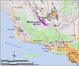
The Midway-Sunset Oil Field is a large oil field in Kern County, San Joaquin Valley, California in the United States. It is the largest known oilfield in California and the third largest in the United States.

South Belridge Oil Field

The South Belridge Oil Field is a large oil field in northwestern Kern County, San Joaquin Valley, California, about forty miles west of Bakersfield. Discovered in 1911, and having a cumulative production of over 1,500 million barrels (240,000,000 m3) of oil at the end of 2008, it is the fourth-largest oil field in California, after the Midway-Sunset Oil Field, Kern River Oil Field, and Wilmington Oil Field, and is the sixth-most productive field in the United States. Its estimated remaining reserves, as of the end of 2008, were around 494 million barrels (78,500,000 m3), the second-largest in the state, and it had 6,253 active wells. The principal operator on the field was Aera Energy LLC, a joint venture between Royal Dutch Shell and ExxonMobil. Additionally, the field included the only onshore wells in California owned and operated by ExxonMobil.

Coalinga Oil Field

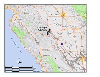
The Coalinga Oil Field is a large oil field in western Fresno County, California, in the United States. It surrounds the town of Coalinga, about halfway between Los Angeles and San Francisco, to the west of Interstate 5, at the foot of the Diablo Range. Discovered in the late 19th century, it became active around 1890, and is now the eighth-largest oil field in California, with reserves totaling approximately 58 million barrels (9,200,000 m3), and over 1,600 active oil wells. The principal operators on the field, as of 2008, were Chevron Corp. and Aera Energy LLC.

Buena Vista Oil Field oil field in California, United States

The Buena Vista Oil Field, formerly the Naval Petroleum Reserve No. 2 (NPR-2) is a large oil field in Kern County, San Joaquin Valley, California in the United States. Discovered in 1909, and having a cumulative production of approximately 667 million barrels (106,000,000 m3), it is the tenth-largest oil field in California. It is also one of the closest to being exhausted, having a total reserve of only about one percent of its original oil, and having produced a mere 713,000 barrels (113,400 m3) in 2006.

Cymric Oil Field

The Cymric Oil Field is a large oil field in Kern County, California in the United States. While only the 14th-largest oil field in California in total size, in terms of total remaining reserves it ranks fifth, with the equivalent of over 119 million barrels (18,900,000 m3) still in the ground. Production at Cymric has been increasing faster than at any other California oil field.

Lost Hills Oil Field

The Lost Hills Oil Field is a large oil field in the Lost Hills Range, north of the town of Lost Hills in western Kern County, California, in the United States.

Mount Poso Oil Field

The Mount Poso Oil Field is a large oil and gas field in the lower foothills of the Sierra Nevada in Kern County, California, United States. Discovered in 1926, and relatively close to exhaustion with less than three percent of its original oil remaining, it is the 21st largest field in California by total ultimate oil recovery, having a cumulative production of close to 300 million barrels (48,000,000 m3). The current principal operator of the field is Plains Exploration & Production; 652 wells remained active at the end of 2006, while production had dwindled to 554,000 barrels (88,100 m3) during that year, from a peak of over 9 million barrels (1,400,000 m3) in 1981.

McKittrick Oil Field

The McKittrick Oil Field is a large oil and gas field in western Kern County, California. The town of McKittrick overlies the northeastern portion of the oil field. Recognized as an oil field in the 19th century, but known by Native Americans for thousands of years due to its tar seeps, the field is ranked 19th in California by total ultimate oil recovery, and has had a cumulative production of over 303 million barrels (48,200,000 m3) of oil. The principal operators of the field as of 2008 were Chevron Corp. and Aera Energy LLC, but many independent oil exploration and production companies were also active on the field. The California Department of Oil, Gas and Geothermal Resources (DOGGR) estimates approximately 20 million recoverable barrels of oil remain in the ground.

South Cuyama Oil Field oil field

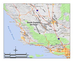
The South Cuyama Oil Field is a large oil and gas field in the Cuyama Valley and the adjacent northern foothills of the Sierra Madre Mountains in northeastern Santa Barbara County, California. Discovered in 1949, and with a cumulative production of around 225 million barrels (35,800,000 m3) of oil, it ranks 27th in size in the state, but is believed to retain only approximately two percent of its original oil, according to the official estimates of the California Department of Oil, Gas, and Geothermal Resources (DOGGR). Of the top forty onshore oil fields in California, it is the most recent to be discovered, but by the end of 2008 only 87 wells remained in production.

Fruitvale Oil Field

The Fruitvale Oil Field is a large oil and gas field in the southern San Joaquin Valley, California, within and just northwest of the city of Bakersfield, along and north of the Kern River. It is one of the few oil fields in the California Central Valley which is mostly surrounded by a heavily populated area. Discovered in 1928, and with a cumulative total recovery of more than 124 million barrels (19,700,000 m3) of oil at the end of 2006, it is 41st in size among California oil fields, and according to the California Department of Oil, Gas, and Geothermal Resources (DOGGR) its total reserve amounts to a little less than ten percent of its original oil.

Round Mountain Oil Field

The Round Mountain Oil Field is a large oil and gas field in the foothills of the Sierra Nevada, about 10 miles (16 km) northeast of Bakersfield, California, United States. It is east of the giant Kern River Oil Field, one of the largest in the United States, and also close to the Mount Poso Oil Field and Kern Front Oil Field. With a cumulative total recovery of more than 110 million barrels (17,000,000 m3) of oil, it is the 48th largest oil field in California, but remains relatively productive with still about ten percent of its reserves remaining in the ground, according to the California Department of Oil, Gas, and Geothermal Resources (DOGGR).

North Belridge Oil Field

The North Belridge Oil Field is a large oil field along California State Route 33 in the northwestern portion of Kern County, California, about 45 miles west of Bakersfield. It is contiguous with the larger South Belridge Oil Field to the southeast, in a region of highly productive and mature fields. Discovered in 1912, it has had a cumulative production of 136,553,000 barrels (21,710,200 m3) of oil, and retains 27,443,000 barrels (4,363,100 m3) in reserve, as of the end of 2006, making it the 40th largest oil field in the state.

Ventura Oil Field oilfield north of the city of Ventura, California, United States

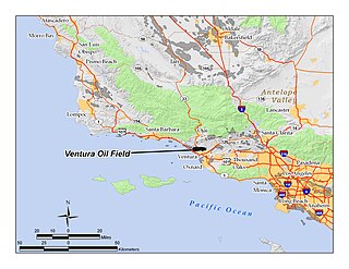
The Ventura Oil Field is a large and currently productive oil field in the hills immediately north of the city of Ventura in southern California in the United States. It is bisected by California State Route 33, the freeway connecting Ventura to Ojai, and is about eight miles (13 km) long by two across, with the long axis aligned east to west. Discovered in 1919, and with a cumulative production of just under a billion barrels of oil as of 2008, it is the tenth-largest producing oil field in California, retaining approximately 50 million barrels in reserve, and had 423 wells still producing. As of 2009 it was entirely operated by Aera Energy LLC.

Oxnard Oil Field

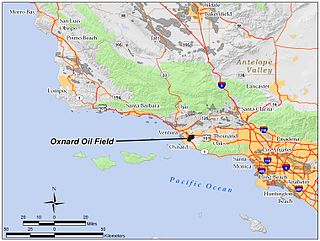
The Oxnard Oil Field is a large and currently productive oil field in and adjacent to the city of Oxnard, in Ventura County, California in the United States. Its conventional oil reserves are close to exhaustion, with only an estimated one percent of the original oil recoverable with current technology remaining: 434,000 barrels (69,000 m3) out of an original 43.5 million. However, the reservoir includes an enormous deposit of tar sands, ultra-heavy oil classed as an unconventional petroleum reserve, and potentially containing 400 million barrels (64,000,000 m3) of oil equivalent, should it become economically feasible to extract. Present operators on the field include Tri-Valley Oil & Gas Co., Anterra Energy Services, Inc., Chase Production Co., and Occidental Petroleum through its Vintage Production subsidiary. As of the beginning of 2009, there were 34 active wells on the field.

Russell Ranch Oil Field

The Russell Ranch Oil Field is an oil and gas field in the Cuyama Valley of northern Santa Barbara and southern San Luis Obispo Counties, California, in the United States. Discovered in 1948, and reaching peak production in 1950, it has produced over 68 million barrels (10,800,000 m3) of oil in its lifetime; with only an estimated 216,000 barrels (34,300 m3) of recoverable oil remaining, and having produced around 66,000 in 2008, it is considered to be close to exhaustion. The primary operator on the field as of 2010 is E&B Natural Resources, which also runs the nearby South Cuyama Oil Field.

Semitropic Oil Field

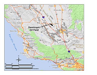
The Semitropic Oil Field is an oil and gas field in northwestern Kern County in California in the United States, within the San Joaquin Valley. Formerly known as the Semitropic Gas Field, it was discovered by the Standard Oil Company of California in 1935, and first understood to be primarily a natural gas reservoir; however, in 1956 a much deeper oil-bearing zone was discovered. The field contains the deepest oil well ever drilled in California, at 18,876 feet (5,753 m). At the end of 2008 the field still had 56 active oil wells, most of which were owned by Occidental Petroleum, and the field had an estimated 343,000 barrels of oil still recoverable with current technology.

Guijarral Hills Oil Field

The Guijarral Hills Oil Field is a formerly-productive oil and gas field near Coalinga on the western side of the Central Valley in central California in the United States. Discovered in 1948, and having produced 5.4 million barrels (860,000 m3) of oil during its peak year in 1950, it now has but one active oil well producing a little over a barrel of oil a day, and is very near to exhaustion, with only 343,000 recoverable barrels of oil remaining throughout its 2,515-acre (10.18 km2) extent according to the official California State Department of Conservation estimate. As of 2010, the only active operator was Longview Production Company.

Mountain View Oil Field

The Mountain View Oil Field is a large, mature, but still-productive oil field in Kern County, California, in the United States, in the extreme southern part of the San Joaquin Valley southeast of Bakersfield. It underlies the town of Arvin, as well as some smaller agricultural communities. The field is spread out across a large area, covering just under 8 square miles (21 km2), with wells and storage facilities widely dispersed throughout the area, scattered among working agricultural fields of broccoli and carrots as well as citrus orchards. Discovered in 1933, it has produced over 90 million barrels (14,000,000 m3) of oil in its lifetime, and although declining in production is one of the few inland California fields in which new oil is still being discovered.

Edison Oil Field

The Edison Oil Field is a large oil field in Kern County, California, in the United States, in the southeastern part of the San Joaquin Valley and adjacent foothills east-southeast of Bakersfield. The field has a total productive area of over 8,000 acres (32 km2), most of which is intermingled with agricultural land uses; oil pumps and storage tanks are surrounded with row crops and orchards in much of the field's extent. Discovered in 1928, and with a cumulative production of 149 million barrels (23,700,000 m3) of oil as of 2008, and having over 6 million barrels (950,000 m3) in reserve, it is ranked 38th among California's oil fields by total ultimate recovery. It is a mature field in decline, and is run entirely by small independent operators. As of 2008, there were 40 different oil companies active on the field, one of the most in the state for a single field. 914 wells remained active on the field, averaging only two barrels of oil per well per day from the dwindling reservoirs.

References

Notes

Coordinates: 35°29′04″N119°02′25″W / 35.4844°N 119.0403°W / 35.4844; -119.0403