
Essen is the central and, after Dortmund, second-largest city of the Ruhr, the largest urban area in Germany. Its population of 584,580 makes it the fourth-largest city of North Rhine-Westphalia after Cologne, Düsseldorf and Dortmund, as well as the ninth-largest city of Germany. Essen lies in the larger Rhine-Ruhr metropolitan region, second largest by GDP in the EU, and is part of the cultural area of Rhineland. Because of its central location in the Ruhr, Essen is often regarded as the Ruhr's "secret capital". Two rivers flow through the city: the Emscher in the north, and in the south the Ruhr River, which is dammed in Essen to form the Lake Baldeney (Baldeneysee) and Lake Kettwig reservoirs. The central and northern boroughs of Essen historically belong to the Low German (Westphalian) language area, and the south of the city to the Low Franconian Bergish area.

The Bergisches Land is a low mountain range in the state of North Rhine-Westphalia, Germany, east of the Rhine and south of the Ruhr. The landscape is shaped by forests, meadows, rivers and creeks and contains over twenty artificial lakes. Wuppertal is the biggest town, while the southern part has economic and socio-cultural ties to Cologne. Wuppertal and the neighbouring cities of Remscheid and Solingen form the Bergisches Städtedreieck.
Mettmann is a Kreis (district) in the middle of North Rhine-Westphalia, Germany. Neighboring are the Ennepe-Ruhr, Rhein-Kreis Neuss, Rheinisch-Bergischer Kreis and the district-free cities Cologne, Leverkusen, Wuppertal, Solingen, Düsseldorf, Duisburg, Mülheim, Essen. It is the most densely populated rural district in Germany; it borders Düsseldorf Airport in the northwestern district borders, on the city limits of Ratingen, and is also near Cologne Bonn Airport. It was named after Mettmann, its district seat.

Heiligenhaus is a town in the district of Mettmann, in North Rhine-Westphalia, Germany, in the suburban Rhine-Ruhr area. It lies between Düsseldorf and Essen.
Velbert is a town in the district of Mettmann, in the German state of North Rhine-Westphalia. The town is renowned worldwide for the production of locks and fittings.

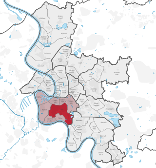
Werden is a southern borough of the city of Essen in Germany. It belongs to the city district IX Werden/Kettwig/Bredeney and has 9,998 inhabitants as of June 30, 2006. The borough occupies a space of 4.04 km2 (1.56 sq mi) and is situated at a median height of 58 m above sea level (NN).
The Verkehrsverbund Rhein-Ruhr, abbreviated VRR, is a public transport association (Verkehrsverbund) in the German state of North Rhine-Westphalia. It covers most of the Ruhr area, as well as neighbouring parts of the Lower Rhine region, including Düsseldorf and thus large parts of the Rhine-Ruhr conurbation. It was founded on 1 January 1980, and is Europe’s largest body of such kind, covering an area of some 5,000 km2 (1,900 sq mi) with more than 7.8 million inhabitants, spanning as far as Dorsten in the north, Dortmund in the east, Langenfeld in the south, and Mönchengladbach and the Dutch border in the west.
Bilk is a quarter (Stadtteil) of Düsseldorf. Together with Oberbilk, Unterbilk, Hamm, Flehe and Volmerswerth it constitutes Borough 3, which is the most populous borough of Düsseldorf. Bilk has an area of 6.07 km2 (2.34 sq mi), and 41,150 inhabitants (2020). Heinrich-Heine-University is in Bilk.

Kettwig is a railway station in the city of Essen in western Germany on the Ruhr Valley Railway.

Kettwig Stausee is a railway station in the city of Essen in western Germany on the Ruhr Valley line. It serves the southern part of the Kettwig borough, Kettwig vor der Brücke, and is situated right next to the river Ruhr.
Ratingen-Homberg is that part of the city of Ratingen, in Mettman district, North Rhine-Westphalia that, until the bringing of industrialisation to the city, was the independent village of Homberg - at that time being in the district Homberg-Meiersberg, with its scenic churches, one Protestant and one Catholic.
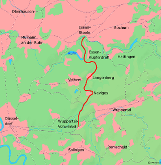
The Wuppertal-Vohwinkel-Essen Überruhr Railway is a 30 km (19 mi) long, continuous two-track electrified main line. It is known as the Prince William Railway, the first railway linking the valleys of the Wupper and the Ruhr.
Bergish is a collective name for a group of West Germanic dialects spoken in the Bergisches Land region east of the Rhine in western Germany.
The actual boundaries of the Ruhr vary slightly depending on the source, but a good working definition is to define the Lippe and Ruhr as its northern and southern boundaries respectively, the Rhine as its western boundary, and the town of Hamm as the eastern limit.

The Ruhr Valley Railway is a partly abandoned railway line in the German state of North Rhine-Westphalia, running from Düsseldorf-Rath via Old Kupferdreh station, Bochum-Dahlhausen, Witten-Herbede, Hagen-Vorhalle and Schwerte to Warburg. It was built between 1872 and 1876 by the Bergisch-Märkische Railway Company, one of the three major private railway companies in the Ruhr area. The railway tracks that were built along the Ruhr river had a relatively uniform grade that was suitable for railway operations at the time.

The Essen-Werden to Essen railway is an electrified railway line in the German state of North Rhine-Westphalia. It is a main line railway with two tracks, except for the Stadtwald Tunnel, running through the metropolitan area of Essen and connecting Essen-Werden station with Essen Hauptbahnhof.

The Regiobahn is the operator of the S28 line of the Rhine-Ruhr S-Bahn between Kaarst, Düsseldorf, Mettmann and Wuppertal and the RE 47 between Düsseldorf and Remscheid-Lennep in the state of North Rhine-Westphalia, Germany.

Mülheim-Styrum station is located in the district of Styrum in the German city of Mülheim in the German state of North Rhine-Westphalia. It is on the Witten/Dortmund–Oberhausen/Duisburg line and is classified by Deutsche Bahn as a category 3 station.
Velbert is a German town in North Rhine-Westphalia which made up of three former towns: Velbert, Neviges and Langenberg. The town's history began during the Middle Ages.
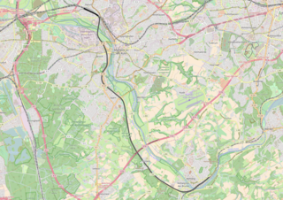
The Lower Ruhr Valley Railway is a former railway in the German state of North Rhine-Westphalia. It was opened on 24 January 1876 by the Bergisch-Märkische Railway Company along the Ruhr to the southwest of the city of Mülheim an der Ruhr and connects Mülheim-Styrum on the Witten/Dortmund–Oberhausen/Duisburg railway and Essen-Kettwig on the Ruhr Valley Railway.


