
Centennial Airport is a public use airport owned by the Arapahoe County Public Airport Authority in the Denver-Aurora metropolitan area, 15 nautical miles southeast of downtown Denver, Colorado, United States. Located in Dove Valley, a census designated place in Arapahoe County, the airport's runways extend into Douglas County.

Chicago Executive Airport, formerly Palwaukee Municipal Airport, is a public airport 18 miles (33 km) northwest of Chicago, in the village of Wheeling in Cook County, Illinois, United States. It is owned by the City of Prospect Heights and the Village of Wheeling.

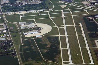
Addison Airport is a public airport in Addison, in Dallas County, Texas, United States, 9 mi north of downtown Dallas. It opened in 1954 and was purchased by the town of Addison in 1976.

Danbury Municipal Airport is a public use general aviation and commercial airport located three miles (5 km) southwest of the central business district of Danbury, in Fairfield County, Connecticut, United States. The airport opened in 1930. It is currently run by the City of Danbury under the management of Michael Safranek. It is included in the Federal Aviation Administration (FAA) National Plan of Integrated Airport Systems for 2017–2021, in which it is categorized as a regional reliever airport facility.
DuPage Airport is a general aviation airport located 29 miles (47 km) west of downtown Chicago in West Chicago, DuPage County, Illinois, United States. It is owned and operated by the DuPage Airport Authority, which is an independent government body established by law by the state of Illinois. It also serves as a relief airport for O'Hare International Airport and Chicago Midway International Airport, both in nearby Chicago.

Zamperini Field is a public airport three miles (5 km) southwest of downtown Torrance, in Los Angeles County, California, United States.
Key Lime Air is a United States airline with corporate headquarters at Denver International Airport in Denver, Colorado, within the Denver metropolitan area. Established in 1997, Key Lime Air operates scheduled air service, various types of public and private charter, and United Parcel Service cargo feeder operations.
Campbell Airport is a public-use airport located two miles (3 km) southwest of the central business district of Grayslake, a village in Lake County, Illinois, United States. It is privately owned by Kane Illinois Properties, Inc.
Poplar Grove Airport is a small general aviation airport located in Poplar Grove, Illinois, United States. The airport was founded in 1972 as Belvidere Airport and renamed in 1994. It is located 3 miles south of Poplar Grove, and 3 miles north of Belvidere. The airport is privately owned and open to the public.
Anderson Municipal Airport is a public use airport three miles east of Anderson in Madison County, Indiana. The National Plan of Integrated Airport Systems for 2011–2015 categorized it as a general aviation facility. The airport currently has no scheduled air service however, is one of the busiest general aviation airports in the State of Indiana given its high volume of flight training and charter traffic.

Joliet Regional Airport is a public use airport located four nautical miles (7 km) west of the central business district of Joliet, a city in Will County, Illinois, United States. It is owned by the Joliet Park District.

Lawrenceville–Vincennes International Airport is a public use airport in Lawrence County, Illinois, United States. Owned by the Bi-State Authority, it is located three nautical miles (6 km) northeast of the city of Lawrenceville, Illinois and also serves the city of Vincennes in Knox County, Indiana. This airport is included in the National Plan of Integrated Airport Systems for 2011–2015, which categorized it as a general aviation facility.
Medina Municipal Airport is a public use airport in Medina County, Ohio, United States. It is owned by the City of Medina and is located four nautical miles (7.41 km) east of the city's central business district. According to the FAA's National Plan of Integrated Airport Systems for 2007-2011, it is categorized as a reliever airport.
Paul C. Miller–Sparta Airport is a public airport located 3 mi (5 km) southeast of Sparta, Michigan. Established in 1941, the airport is currently owned and operated by the Village of Sparta and is self-supporting, requiring no public funding. It is included in the Federal Aviation Administration (FAA) National Plan of Integrated Airport Systems for 2017–2021, in which it is categorized as a regional general aviation facility.
Greenville Municipal Airport is a city-owned, public-use airport located three nautical miles (6 km) south of the central business district of Greenville, a city in Montcalm County, Michigan, United States. It is included in the Federal Aviation Administration (FAA) National Plan of Integrated Airport Systems for 2017–2021, in which it is categorized as a local general aviation facility.
Williams County Airport is a publicly owned, public use general aviation airport serving Bryan, Ohio.

On 12 May 2021, Key Lime Air Flight 970, a Fairchild Swearingen Metroliner operating a chartered cargo flight from Salida to Centennial, Colorado collided in mid-air with a private Cirrus SR22. Despite having sustained severe damage, the Swearingen Metroliner managed to land safely while the Cirrus SR22 deployed its CAPS system and safely parachuted to the ground. All three occupants on board both aircraft survived uninjured.
The Dacy Airport is a privately owned, public-use airport located 1 mile southwest Harvard, Illinois.
Boyne City Municipal Airport is a public use airport located in the city limits of Boyne City, Michigan. The airport is publicly owned by the City of Boyne City. It is four nautical miles southeast of the Boyne Mountain Airport.
